Radar reflectivity estimation method and device based on pix2pix

A radar reflection and preset technology, which is applied in neural learning methods, instruments, biological neural network models, etc., to achieve the effect of reducing network parameters and improving computing efficiency

Pending Publication Date: 2022-02-25
NAT SATELLITE METEOROLOGICAL CENT
View PDF0 Cites 0 Cited by
  • Summary
  • Abstract
  • Description
  • Claims
  • Application Information

AI Technical Summary

Problems solved by technology

[0005] For this reason, the present invention provides a radar reflectivity estimation method and device based on pix2pix, which solves the problem of radar observation blind spots by estimating radar reflectivity, and improves the accuracy of short-imminent forecasting

Method used


Image

  • Radar reflectivity estimation method and device based on pix2pix
  • Radar reflectivity estimation method and device based on pix2pix
  • Radar reflectivity estimation method and device based on pix2pix

Examples


Embodiment 1

[0032] In Embodiment 1 of the present invention, the data source used by the remote sensing image cloud detection method based on depth semantic segmentation is as follows:

[0033] The FY-4A L1 level 4KM data and 1KM radar basic reflectivity from January 2019 to December 2020 are used as training samples.

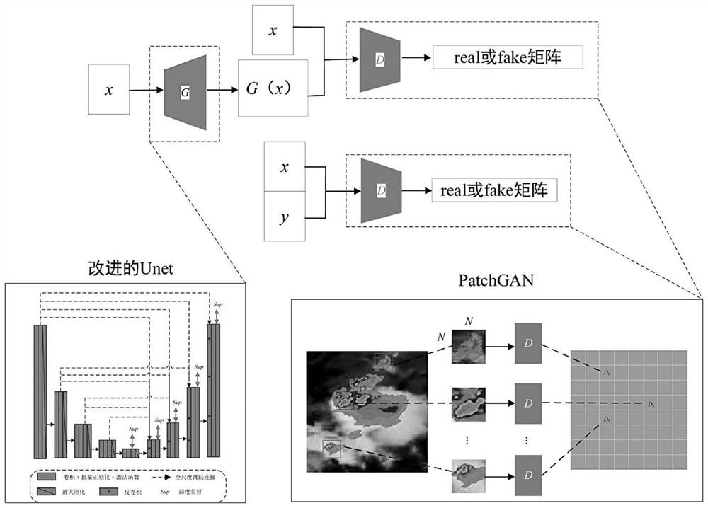
[0034] see figure 1 and figure 2 , the radar reflectivity estimation method based on pix2pix of the present invention, comprises:

[0035] Data preprocessing: through dispersion standardization, map the remote sensing image pixel values ​​outside the effective value range of the preset spectral channel to the [0,1] range, and convert the mapped remote sensing image pixel values ​​into the value range 0~ Image pixel value of 255;

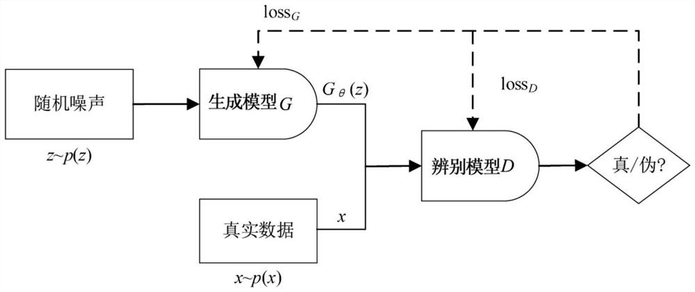
[0036] Model building: carry out pix2pix confrontation neural network model construction, described pix2pix confrontation neural network model includes generation model G and discrimination model D;

[0037] The generation model G uses an imag...

Embodiment 2

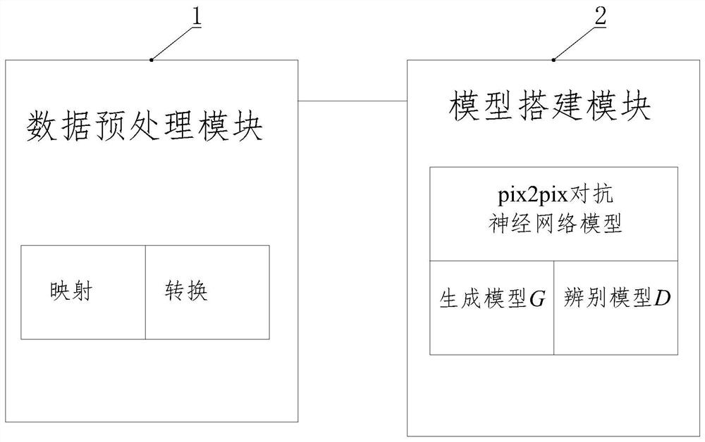
[0062] see image 3 , Embodiment 2 of the present invention provides a device for estimating radar reflectivity based on pix2pix, and adopts the method for estimating radar reflectivity based on pix2pix in Embodiment 1 or any possible implementation thereof, including:

[0063] The data preprocessing module 1 is used to map the remote sensing image pixel values ​​outside the effective value range of the preset spectral channel to the range [0,1] through dispersion standardization, and convert the mapped remote sensing image pixel values ​​to Image pixel value in the range of 0 to 255;

[0064] Model building module 2, for carrying out pix2pix against neural network model construction, described pix2pix against neural network model comprises generation model G and discrimination model D;

[0065] The generation model G uses an image segmentation network, and the image segmentation network is first encoded and then decoded. The encoding is completed by convolution with a step s...

Embodiment 3

[0075] Embodiment 3 of the present invention provides a computer-readable storage medium, in which the program code of the radar reflectivity estimation method based on pix2pix is ​​stored, and the program code includes the program code used to execute Embodiment 1 or any Instructions for possible implementations of the pix2pix-based radar reflectivity estimation method.

[0076] The computer-readable storage medium may be any available medium that can be accessed by a computer, or a data storage device such as a server, a data center, etc. integrated with one or more available media. The available medium may be a magnetic medium (for example, a floppy disk, a hard disk, or a magnetic tape), an optical medium (for example, DVD), or a semiconductor medium (for example, a solid state disk (SolidState Disk, SSD)).


PUM


Abstract

The invention discloses a radar reflectivity estimation method and device based on pix2pix, wherein the method comprises the steps that: a remote sensing image pixel value outside a preset spectrum channel effective value range is mapped to a range of [0,1] through deviation standardization, and the mapped remote sensing image pixel value is converted into an image pixel value in a value range of 0-255, wherein the pix2pix adversarial neural network model comprises a generation model and a discrimination model; the generation model uses an improved Unet network, the network performs coding and then performs decoding, coding is completed by adopting convolution with step length, and full-scale jump connection and depth supervision are utilized in a network architecture; and the discrimination model adopts a condition discriminator. According to the invention, severe convection weather monitoring in an area without radar coverage can be effectively compensated; network parameters can be reduced, and calculation efficiency is improved; the local image features are extracted and represented, and the local image features and the overall image features are fused, so that high-resolution images can be generated favourably.

Description

technical field [0001] The invention belongs to the technical field of environmental monitoring, and in particular relates to a radar reflectivity estimation method and device based on pix2pix. Background technique [0002] The FY-4 satellite is a new generation of geostationary meteorological satellite developed by China after the FY-2 satellite. As a new generation of geostationary orbit meteorological satellite in China, the FY-4 satellite undertakes high-frequency observations of the earth's regional atmosphere and surface. The main application goals are Provide monitoring data and products to improve the accuracy of weather forecasts. The main tasks of the FY-4 optical series satellites are: to obtain multi-spectral and high-precision quantitative observation data and images of the earth's surface and clouds, especially high-frequency regional images, and to comprehensively improve the multi-spectral and atmospheric parameters of the earth's surface and atmosphere. Hig...

Claims


Application Information

Patent Timeline
Patent Type & Authority Applications(China)
IPC IPC(8): G06V20/10G06V20/13G06V10/26G06V10/44G06V10/764G06V10/82G06K9/62G06N3/04G06N3/08
CPCG06N3/08G06N3/045G06F18/241
Inventor 高昂肖萌杨军唐世浩郑伟姜灵峰咸迪
Owner NAT SATELLITE METEOROLOGICAL CENT
Why Eureka
Try Eureka