Method and system for constructing geographical environment knowledge base of urban agglomeration with distributed architecture

A distributed architecture and geographical environment technology, applied in the field of artificial intelligence and information processing, can solve the problems of inability to achieve precision, a lot of time, energy cost, large equipment cost and energy consumption, etc., to improve the recognition accuracy and fineness , reduce equipment cost and energy consumption, and increase the effect of creating speed

Active Publication Date: 2021-01-01
GUANGZHOU INST OF GEOGRAPHY GUANGDONG ACAD OF SCI
View PDF5 Cites 0 Cited by
  • Summary
  • Abstract
  • Description
  • Claims
  • Application Information

AI Technical Summary

Problems solved by technology

In the prior art, the construction of the knowledge base related to the urban geographical environment is usually completed by experts in the field or other people through manual editing, but this construction of the knowledge base by personnel requires a lot of time, energy and cost, and It cannot be refined, and it is not easy to finely grasp and manage the geographical environment of urban agglomerations
When updating the knowledge base in the future, the operator needs to have a full understanding of the contents of the knowledge base before updating. Therefore, the existing method of manually constructing the geographic environment of urban agglomerations is not conducive to the maintenance of the knowledge base.
[0004] With the development of technology, high-resolution satellite images and aerial images are used to acquire urban surface images. The images contain the geographical environment information of urban agglomerations, especially the geographical environment information of the surface. However, image recognition in the prior art is mostly Partial recognition, discrete recognition or artificial marking by non-professionals, high error rate, incomplete, lack of calculation and storage of entity features
Statistics, and it is difficult to conduct accurate and comprehensive query and display through attribute information or fields
In addition, due to the large amount of high-resolution satellite images of urban agglomerations, when performing operations such as image recognition, processing, calculation, and storage, the requirements for computer equipment are extremely high, and a large amount of equipment costs and energy consumption are required.
In addition, traditional image recognition technology is generally only for a certain type of information recognition. Due to the limitation of computing power and recognition methods, the fineness, accuracy and processing speed of the image processing are usually contradictory, and it is difficult to apply to the processing of urban The situation where there is a large amount of data and complex types in the geographical environment of the group

Method used


Image

  • Method and system for constructing geographical environment knowledge base of urban agglomeration with distributed architecture
  • Method and system for constructing geographical environment knowledge base of urban agglomeration with distributed architecture
  • Method and system for constructing geographical environment knowledge base of urban agglomeration with distributed architecture

Examples


Embodiment Construction

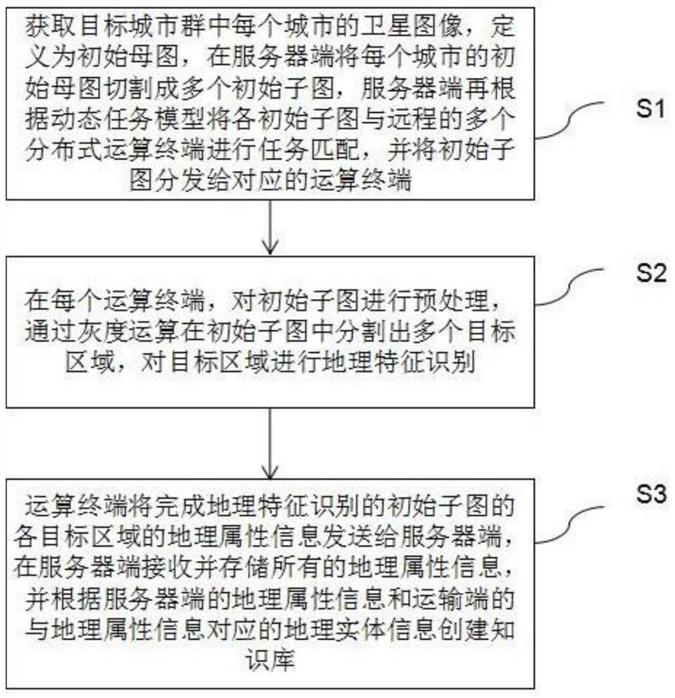
[0066]Such asfigure 1 ,figure 2 As shown, this embodiment provides a method for building a geographical environment knowledge base of urban agglomerations in a distributed architecture, including the steps:

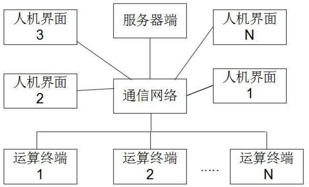
[0067]S1: Obtain the satellite image of each city in the target city group and define it as the initial mother image. The initial mother image of each city is cut into multiple initial subimages on the server side, and the server side then divides each initial child image according to the dynamic task model. The map is matched with multiple remote distributed computing terminals, and the initial sub-map is distributed to the corresponding computing terminals. Among them, the server side and multiple distributed computing terminals communicate through wired and / or wireless networks. Among them, the satellite image is preferably a bitmap format to facilitate pixel gray scale calculation and adjustment.

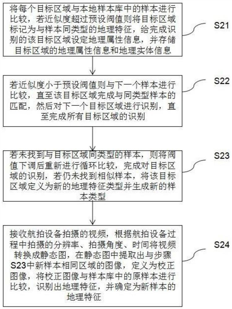
[0068]Specifically, in step S1, the initial mother image of each city is uniformly...


PUM


Abstract

The present invention provides a method and system for constructing an urban agglomeration geographic environment knowledge base with a distributed architecture, including: cutting the initial master map of each city into multiple initial sub-graphs on the server side, and distributing the initial sub-graphs to corresponding operations terminal; at each computing terminal, preprocess the initial submap, segment multiple target areas in the initial submap through grayscale operations, and identify the geographic features of the target areas; the computing terminal will complete the initial submap of geographic feature recognition The geographical attribute information of each target area in the graph is sent to the server, and a knowledge base is created according to the geographical attribute information on the server and the geographical entity information corresponding to the geographical attribute information on the transport end. Improve the utilization rate of existing equipment, reduce equipment cost and energy consumption, make full use of the computing power of multiple computing terminals, increase the speed of knowledge base creation, and overcome the accuracy and fineness of large-scale geographic feature recognition in the existing technology A defect that contradicts the processing speed.

Description

Technical field[0001]The present invention relates to the field of artificial intelligence and information processing technology, in particular to a method and system for constructing a geographical environment knowledge base of urban agglomerations with a distributed architecture.Background technique[0002]Geographical environment refers to the geographical location of a certain society and the sum of various natural conditions associated with it, including climate, land, rivers, lakes, mountains, minerals, and animal and plant resources. The geographic environment of urban agglomerations is an important kind of geographic environment, including buildings, transportation facilities, recreational green spaces, urban mountains, waterways, and underground features in and between multiple cities.[0003]The geographic environment of urban agglomerations involves a wide area, many types of geographic environments, and trivial information. In the prior art, the current construction of the k...

Claims


Application Information

Patent Timeline
Patent Type & Authority Patents(China)
IPC IPC(8): G06K9/00G06K9/34G06K9/46G06K9/62G06F16/29
CPCG06F16/29G06V20/13G06V10/26G06V10/50G06F18/22G06F18/24Y02D10/00
Inventor 陈军袁少雄王钧
Owner GUANGZHOU INST OF GEOGRAPHY GUANGDONG ACAD OF SCI
Why Eureka
Try Eureka