Erosion ditch monitoring method based on close-range photogrammetry

A technology of close-range photography and erosion ditch, which is applied in measuring devices, photo interpretation, weather resistance/light resistance/corrosion resistance, etc. It can solve the problems of lack of universality, bulky equipment, expensive instruments, etc., to improve accuracy and efficiency , Improve the living environment, improve efficiency and accuracy

Inactive Publication Date: 2019-09-17
CHINA WEST NORMAL UNIVERSITY
View PDF5 Cites 7 Cited by
  • Summary
  • Abstract
  • Description
  • Claims
  • Application Information

AI Technical Summary

Problems solved by technology

High-precision RTK-GPS has sub-centimeter-level high-precision positioning features, but it needs to be based on satellite signals. The terrain under field conditions is complex, and the scale of slope gully erosion in micro-topography is small. and Ditch Bottom Line Data Quality
The 3D laser scanner obtains the topographic data of the erosion ditch through the non-contact laser, and can establish the topography model of the erosion ditch to a large extent. It is also difficult to carry and operate in the wild
The technical solution is: a portable corner structure laser soil erosion monitor, including a single-chip microcomputer, a bluetooth communicator, a battery and a laser rangefinder; it is characterized in that the measuring instrument also includes a support frame and a measuring head; the measuring head includes a supporting shell, a sensor base plate and Swing mechanism; the support shell includes a columnar upper shell and a lower shell that are docked up and down and whose axes coincide; a horizontal rotating motor with an output shaft extending vertically upwards is fixed in the lower shell; For the rotating main shaft that is mated with the aforementioned output shaft, the aforementioned patent cannot monitor the form of erosion grooves in different periods
[0005] To sum up, in the field of erosion gully monitoring, there is still a lack of an efficient and convenient monitoring method for medium and small scale erosion gullies

Method used


Image

  • Erosion ditch monitoring method based on close-range photogrammetry

Examples


Embodiment Construction

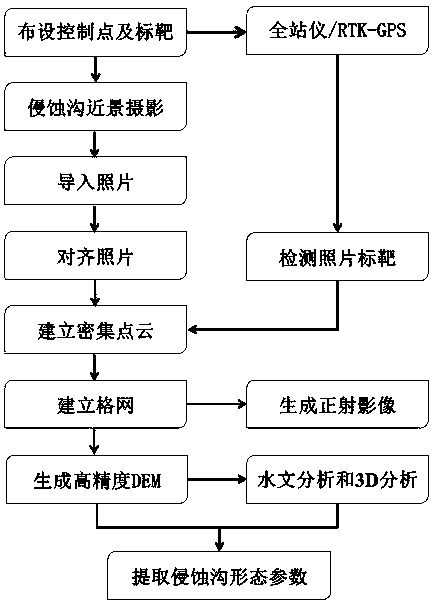
[0032] The present invention will be further elaborated below in conjunction with accompanying drawing, but the present invention is not limited to following embodiment, described method is conventional method unless otherwise specified, and described material all can be obtained from open commercial channel if not specified.

[0033] like figure 1 As shown, a method for monitoring erosion gullies based on close-range photogrammetry includes the following processes:

[0034] Step 1, target layout and measurement for close-range photography:

[0035] Arrange photographic targets (Mark) around the erosion ditch. The setting method of the target (Mark) is: along the line of the erosion ditch and at the bottom of the ditch, arrange them at regular intervals, and use a total station or RTK-GPS for benchmarking The center point of the target is measured to obtain the position information; the target is printed and cut after the output of the Agisoft PhotoScan software, the target c...


PUM


Abstract

The invention discloses an erosion ditch monitoring method based on close-range photogrammetry. The erosion ditch monitoring method comprises the steps that a photographing target is arranged around an erosion ditch, and a total station or an RTK-GPS is adopted for measuring a target center point, and position information is obtained; a non-measuring common digital camera is adopted to rotate around the erosion ditch clockwise (anticlockwise) and manual photographing is carried out; the photo is guided into Agisoft Photoscan software, and the sparse point cloud, dense point cloud and grids are established through camera calibration, photo splicing, target detection operation and the like, and the coordinates of the target point are guided to obtain a digital elevation model and a digital positive projection image of the erosion ditch; and the digital elevation model of the high-precision erosion ditch is guided into ArcGIS 10.2 software, and form parameters and erosion amount information of the erosion ditch are extracted. The method has the advantages that the dependence and the requirement degree of the instrument are low, the cost is low, the experimental consumable is small, the high-quality digital elevation model data can be quickly obtained, and the information of the erosion ditch can be conveniently and accurately extracted.

Description

technical field [0001] The invention belongs to the technical field of water and soil conservation engineering, and relates to an erosion ditch monitoring method, in particular to an erosion ditch monitoring method based on close-range photogrammetry. Background technique [0002] Gully erosion is one of the main forms of slope soil erosion, which increases the sediment yield on the slope several times to dozens of times, seriously destroys agricultural production and ecological environment, and causes great loss of land resources. Accurate and effective monitoring methods are the basis for mastering the change and development of erosion gullies, and are of great significance for in-depth revealing of the formation mechanism of erosion gullies. [0003] Erosion gully monitoring is an important way to effectively extract the morphological parameters of erosion gully. Based on various erosion ditch monitoring technologies at home and abroad, they can be roughly divided into c...

Claims


Application Information

Patent Timeline
Patent Type & Authority Applications(China)
IPC IPC(8): G01C11/02G01C11/04G01N17/00
CPCG01C11/02G01C11/04G01N17/00
Inventor 张斌罗君覃发超吕威刘辉邓青春罗明良郑吉林
Owner CHINA WEST NORMAL UNIVERSITY
Why Eureka
Try Eureka