Pixel-by-pixel atmospheric correction method for calculating look-up table online

An atmospheric correction and look-up table technology, applied in the field of atmospheric correction, can solve the problems of complex imaging geometry, slow interpolation, and difficulty in direct use of aerosol inversion and atmospheric correction, achieving high stability, applicability, and high degree of automation Effect

Active Publication Date: 2018-07-06
INST OF REMOTE SENSING & DIGITAL EARTH CHINESE ACADEMY OF SCI
View PDF6 Cites 12 Cited by
  • Summary
  • Abstract
  • Description
  • Claims
  • Application Information

AI Technical Summary

Problems solved by technology

[0004] The characteristics of GF-4 satellite imaging make it difficult to directly use the traditional offline lookup table-based method framework for aerosol retrieval and atmospheric correction of its multispectral data
Due to the geosynchronous orbit, the satellite can be imaged at any time of the day, which makes the imaging geometry between the satellite, the surface and the sun complex, and the number of angle combinations that need to be considered in the establishment of an offline lookup table is multiplied. In order to ensure the accuracy It is necessary to establish a more complex offline lookup table, and at the same time, the calculation amount of multi-dimensional interpolation per pixel will also increase significantly
Experiments show that complex lookup table interpolation is difficult to control the processing time of a single GF-4 image within 30 minutes
In the aerosol estimation process, due to the arbitrariness of the imaging time of the geosynchronous orbit and the sun-synchronous orbit, it is impossible to use the surface reflectance products or aerosol products of other satellite data imaged at similar times, and due to the lack of short-wave infrared bands, through image data Estimating aerosol thickness is more difficult
Traditional atmospheric correction methods based on lookup tables need structural adjustments to overcome the problems of complex table building and slow interpolation in offline lookup tables, improve the method of inverting aerosols based on image data, and aim at high-resolution geosynchronous orbit satellites Data imaging characteristics Customize the special algorithm flow frame of pixel-by-pixel atmospheric correction, provide a robust GF-4 satellite pixel-by-pixel atmospheric correction algorithm program, with the ability to automatically obtain and analyze the input parameters required for atmospheric correction, and have batch processing capabilities , in order to meet the requirements of engineering production of high-precision GF-4 atmospheric correction data products, that is, aerosol and surface reflectance data

Method used


Image

  • Pixel-by-pixel atmospheric correction method for calculating look-up table online
  • Pixel-by-pixel atmospheric correction method for calculating look-up table online
  • Pixel-by-pixel atmospheric correction method for calculating look-up table online

Examples


Embodiment Construction

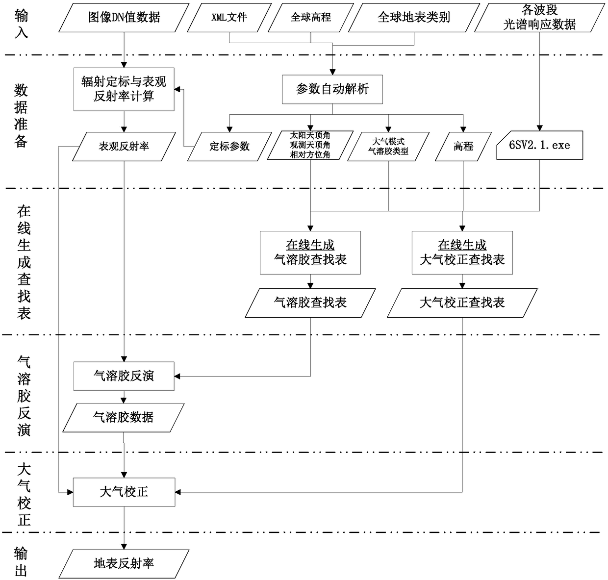
[0024] The present invention realizes an online calculation look-up table pixel-by-pixel atmospheric correction method flow as follows figure 1 Shown, it is described in conjunction with accompanying drawing now.

[0025] figure 1 The "image DN value data" in the "input" part is aimed at the high-resolution multispectral data of geosynchronous orbit satellites, and the image width is limited to no more than 400 kilometers, and the image bands include at least blue band, green band, red band, and near-infrared band 4. The example data of the present invention is the standard data product of GF-4 satellite multispectral image.

[0026] figure 1 The "XML file" in the "input" part of the "XML file" is a file included in the image standard data product and used to save the basic information of image imaging. At present, this type of file of satellite data is usually saved in XML format, and it can usually be obtained directly through this file, or Obtain the parameters required...


PUM


Abstract

The invention discloses a remote-sensing image pixel-by-pixel atmospheric correction method based on a 6S atmospheric radiation transmission software package online calculation. The method comprises the steps that a 6S online parallel computing look-up table is utilized, the look-up table for different aerosol optical thicknesses of a remote-sensing image under different imaging geometry and atmospheric modes is generated, aerosol distribution data is obtained onteh basis of the look-up table, a look-up table of atmospheric correction coefficients is generated, and pixel-by-pixel atmospheric correction is conducted on the basis of the look-up table. Accordingly, the problems that for a traditional method of building the look-up table offline, the application range is limited, the table building amount is large, and pixel-by-pixel multi-dimensional interpolation is complex are solved, and high stability and applicability are achieved for high-resolution remote-sensing image atmosphericcorrection obtained by the Gaofen-4 geosynchronous satellites any time all day.

Description

technical field [0001] The invention relates to an atmospheric correction technology for remote sensing images, in particular to a pixel-by-pixel atmospheric correction technology for on-line calculation lookup tables of high-resolution remote sensing satellite images in geosynchronous orbits. Background technique [0002] Radiation preprocessing of remote sensing images has always been one of the main topics in remote sensing data processing. After the new remote sensing satellites are put into use, the preprocessing of the new data is an urgent issue. The preprocessing of remote sensing images usually includes geometric preprocessing and radiation preprocessing. The main purpose of radiation preprocessing is to remove the influence of atmospheric absorption, Rayleigh scattering of atmospheric molecules and meter scattering of aerosols from the radiation signals observed by remote sensing sensors. , to restore the real reflectivity of the surface. Atmospheric correction i...

Claims


Application Information

Patent Timeline
IPC IPC(8): G06F17/50G06C3/00
CPCG06C3/00G06F30/20Y02E60/00
Inventor 胡昌苗唐娉白洋张正李宏益
Owner INST OF REMOTE SENSING & DIGITAL EARTH CHINESE ACADEMY OF SCI
Why Eureka
Try Eureka