
Equivalent mismatch model multistage calibration method used for increasing satellite image positioning accuracy

A positioning accuracy, satellite image technology, applied in the field of satellite image positioning, can solve problems such as the adverse effects of image positioning accuracy, the inability to effectively achieve high-precision images, the influence of day and night sunlight conditions, climate conditions, etc., to solve the problem of anisotropy Effect

Active Publication Date: 2017-05-31
SHANGHAI SATELLITE ENG INST
View PDF6 Cites 16 Cited by
  • Summary
  • Abstract
  • Description
  • Claims
  • Application Information

AI Technical Summary

Problems solved by technology

[0003] When the satellite is in orbit, it is inevitable to be thermally deformed by the change of external heat flow, which will have a negative impact on the image positioning accuracy
The traditional method is to correct the image based on a sufficient number of uniformly distributed control points on the image. However, when the different detection spectrum bands of the earth remote sensing satellite work all day and all day, they will be affected by the sunlight conditions and climate conditions during the day and night. Obtain a sufficient number of uniformly distributed control points for full field of view calibration; and there is a complex nonlinear relationship between the thermal deformation of the swing-sweep spaceborne camera on the orientation and pointing, and the anisotropy of the pointing effect in the load field of view can be Exceeding 0.01°, it is necessary to carry out on-orbit calibration technology of thermal deformation under sparse control points
[0004] According to literature search, China Invention Patent No. 201410138676.7, the patent name is "A Method for Determining the Positioning Accuracy of Optical Remote Sensing Satellite Image", which only theoretically gives the decomposition of image positioning accuracy index and the method of positioning accuracy estimation, and cannot solve the problem of satellites in orbit. Practical Application of High Precision Image Positioning
U.S. Patent No. US6023291, patent name "Satellitecamera attitude determination and image navigation by means of earth edge and landmark measurement", adopts dot-matrix two-dimensional sweep imaging method, establishes an equivalent mismatch angle positioning model, and proposes to solve landmarks by means of camera on-orbit observation Calculate the equivalent mismatch angle and perform one-day fitting, but when the number of control points is small and the distribution is concentrated, there is an ill-conditioned solution for the multi-source heteroscale thermal deformation imaging model identification, which cannot effectively meet the actual needs of high-precision image positioning tasks

Method used


Image

  • Equivalent mismatch model multistage calibration method used for increasing satellite image positioning accuracy
  • Equivalent mismatch model multistage calibration method used for increasing satellite image positioning accuracy
  • Equivalent mismatch model multistage calibration method used for increasing satellite image positioning accuracy

Examples


Embodiment Construction

[0052] figure 1 As shown, the image positioning method of the present invention is described by taking a geostationary orbit remote sensing satellite as an example. It is composed of a wide field of view large area array 500×500 pixel detector and a two-dimensional pointing mechanism. The image positioning process is as follows:

[0053] First, the camera optical distortion model is accurately calibrated on the ground, and the accuracy is better than 1 pixel, and then the equivalent mismatch angle parameter set in the imaging model caused by the assembly deviation of the optical-mechanical structure is calibrated, and the grid point of the full field of view of the spaceborne camera is calculated. The ideal space pointing of the corresponding detector pixel is converted into the ideal horizontal pointing angle and pitch pointing angle of the camera line of sight under the satellite system.

[0054] On the ground, the camera stellar sensitive ephemeris or landmark observation p...


PUM


Abstract

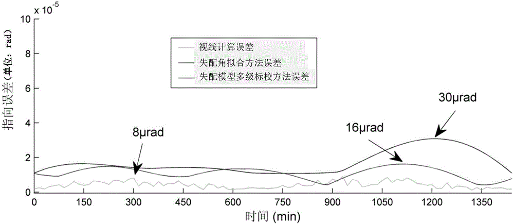
The invention discloses an equivalent mismatch model multistage calibration method used for increasing satellite image positioning accuracy. The equivalent mismatch model multistage calibration method comprises following steps: firstly, a space-borne scanning camera imaging positioning model containing equivalent mismatching angles is constructed; in orbit, fixed stars or terrestrial landmarks are observed via controlling camera intervals; equivalent mismatching angle parameter sets of space-borne cameras on star sensor attitude reference caused by thermal deformation on the stars of the same orbit at different times are calculated; mesh generation of the space-borne camera all view based on two-dimensional scanning rotating angles is carried out; in a one orbit cycle, imaging positioning model parameter reconstitution and high accuracy pointing error multi-stage fitting calibration are carried out so as to obtain stable thermal deformation change rule parameter sets used for high accuracy imaging positioning of a next orbit, and avoid imaging positioning problems of singular equivalent mismatching angle calculating caused by few and scattered, or concentrated camera in-orbit sparse or concentrated control points for observing fixed star or landmarks. The equivalent mismatch model multistage calibration method is capable of solving a technical problem, and realizing high accuracy positioning of triaxial stable scanning optical remote sensing satellite when the control points are few and scattered.

Description

technical field [0001] The invention relates to a satellite image positioning method, more specifically, to a three-axis stable space-borne swing-sweep optical remote sensing satellite image in which few control points are available. According to the geometric characteristics of on-orbit camera imaging, the few control points are realized. All-weather and all-weather image positioning requirements for a large coverage area under certain conditions. Background technique [0002] With the continuous improvement of space-borne camera image spatial resolution and detection requirements, the index requirements for image positioning are also getting higher and higher, and its performance will directly reflect the capability level of a country's quantitative remote sensing business application, which is related to, for example, meteorological satellites. Weather diagnosis, cloud image analysis, etc., as well as target recognition and trajectory tracking, etc. [0003] When the sat...

Claims


Application Information

Patent Timeline
IPC IPC(8): G01C11/02
CPCG01C11/025
Inventor 宋效正俞洁吕建民伍亚运王华陆国平曹建光舒锐
Owner SHANGHAI SATELLITE ENG INST
Learn More