Single cropping rice SAR (Synthetic Aperture Radar) identification method for small and medium-sized fields in complex terrain environment

A complex terrain and recognition method technology, applied in character and pattern recognition, instruments, calculations, etc., can solve the problems of weakening the unique characteristics of rice, inability to effectively distinguish, and mixing of different ground objects, etc., to suppress SAR speckle noise and outliers The effect of retaining the true intensity and high-precision extraction

Active Publication Date: 2022-04-22
NINGBO UNIV
View PDF10 Cites 3 Cited by
  • Summary
  • Abstract
  • Description
  • Claims
  • Application Information

AI Technical Summary

Problems solved by technology

However, these characteristics are often based on the entire growth cycle of rice, which may weaken the unique characteristics of rice growth, resulting in the inability to effectively distinguish other crops with similar dynamic range or variance to rice radar backscatter
On the other hand, the existing research on rice monitoring combined with phenological characteristics is mainly used in plain areas with flat topography, but the phenological information of rice in areas with complex topography is variable, and the relationship between remote sensing terrain shadows and shallow water, and rice surface areas with high water content in the early stage The range of radar backscatter coefficients is similar, which can easily lead to the phenomenon of mixing of different ground objects, and it is impossible to realize high-precision monitoring of rice in complex terrain areas
At the same time, the inherent speckle noise of SAR images will also affect the high-precision SAR classification of crops.

Method used


Image

  • Single cropping rice SAR (Synthetic Aperture Radar) identification method for small and medium-sized fields in complex terrain environment
  • Single cropping rice SAR (Synthetic Aperture Radar) identification method for small and medium-sized fields in complex terrain environment
  • Single cropping rice SAR (Synthetic Aperture Radar) identification method for small and medium-sized fields in complex terrain environment

Examples


Embodiment 1

[0065] Embodiment 1 of the present application provides a single-crop rice SAR identification method for small and medium-sized fields in a complex terrain environment:

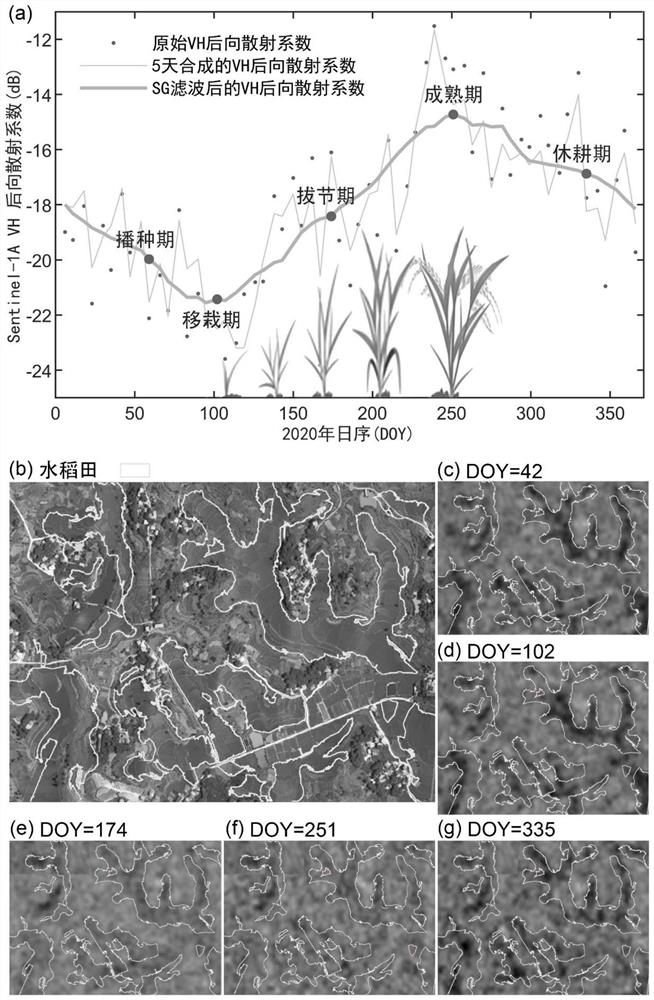
[0066] Step 1. Preprocessing the annual SAR remote sensing image data, converting the pixel value of the SAR remote sensing image into the actual ground object backscattering intensity, and obtaining the annual time series ground object backscattering intensity data;

[0067] Step 2. In each set cycle length, perform an average synthesis of the ground object backscattering intensity data of the annual time series, and perform time series Savitzky-Golay filtering on the synthesized time series data:

[0068]

[0069] In the above formula, Y * is the jth reconstruction value; C i is the coefficient of the i-th point in the sliding window; N is the length of the sliding window, its size is equal to 2m+1, and m is the length of half a sliding window; average value;

[0070] Step 3. Considering that there is...

Embodiment 2

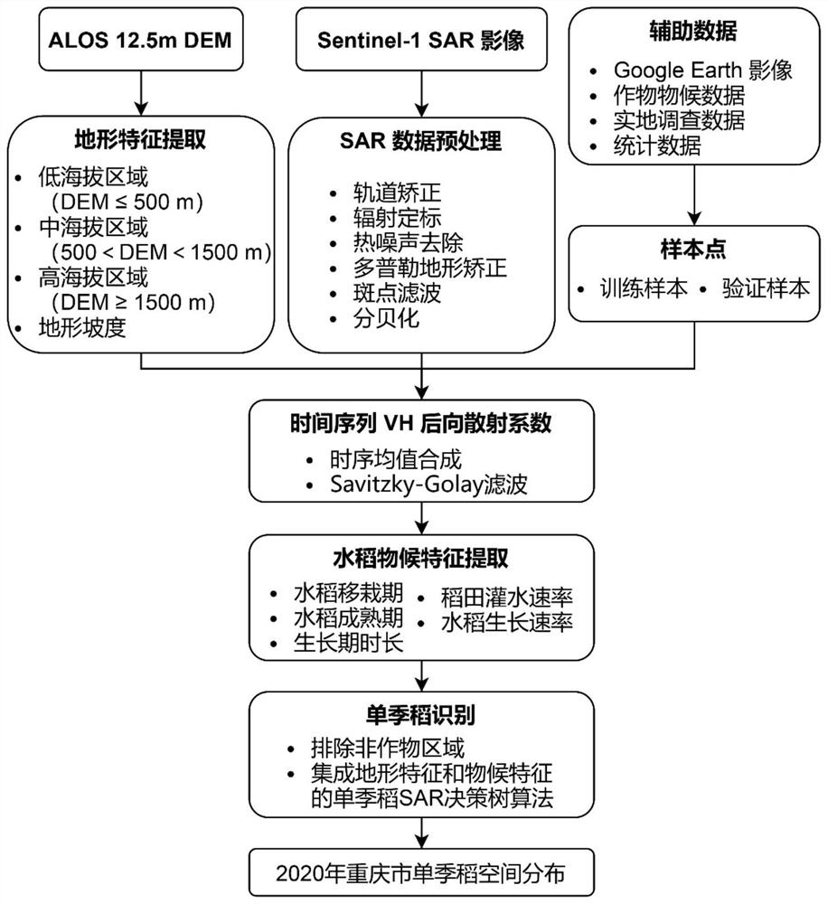
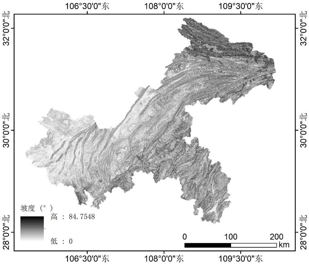
[0077] On the basis of Embodiment 1, Embodiment 2 of the present application provides the practical application of the SAR recognition method for single-crop rice in Embodiment 1 for small and medium-sized field plots under complex terrain environment: Chongqing is a famous mountain city with complex terrain and field plots Broken is a typical single-crop rice planting area; the single-crop rice SAR identification method for small and medium-sized fields under complex terrain environments is applied to Chongqing; the Sentinel-1VH polarization image of Chongqing in 2020 is used to identify single-crop rice. Such as figure 1 As shown, the method of the present embodiment includes the following steps:

[0078]Step 1. Perform orbit correction, thermal noise removal, radiometric calibration, Doppler terrain correction, polarization filtering, and decibelization on the annual C-band synthetic aperture radar SAR image VH polarization data, and convert the original image to The pixel...


PUM


Abstract

The invention relates to a single cropping rice SAR (Synthetic Aperture Radar) identification method for small and medium-sized fields in a complex terrain environment, which comprises the following steps of: preprocessing SAR remote sensing image data of the whole year, and converting SAR remote sensing image pixel values into actual ground feature backscattering intensity to obtain ground feature backscattering intensity data of a time sequence of the whole year; average value synthesis is carried out on the ground feature back scattering intensity data of the whole-year time sequence in each set period length, and time sequence Savitzky-Golay filtering is carried out on the synthesized time sequence data. The method has the advantages that average value synthesis is carried out on the single cropping rice SAR back scattering intensity time sequence, the rice back scattering time sequence is reconstructed by introducing Savitzky-Golay filtering, the influence of SAR speckle noise and abnormal values is effectively restrained, the real intensity of rice back scattering is well reserved, and the method has the advantages of being high in accuracy and high in accuracy. The method can be used for seasonal characterization of phenological development characteristics of rice all the year round, and is beneficial to accurate extraction of phenological characteristics of rice.

Description

technical field [0001] The invention belongs to the field of remote sensing image processing, and in particular relates to a SAR recognition method for single-cropping rice aimed at small and medium-sized fields in a complex terrain environment. Background technique [0002] Timely and accurate acquisition of rice planting area and spatial distribution is a fundamental and important task for the government to accelerate the construction of a modern rice industry system, effectively improve the comprehensive production of rice, and promote the continuous increase of farmers' income and the sustainable development of the rice industry. In recent decades, a large area of ​​cultivated land has either been converted to construction land with urbanization, or returned to forests and grasslands due to ecological restoration, resulting in a rapid decline in the area of ​​rice planting. Especially in areas with complex terrain, the rice management method is mainly based on traditiona...

Claims


Application Information

Patent Timeline
Patent Type & Authority Applications(China)
IPC IPC(8): G06V20/10G06V10/28G06V10/20G06V10/764G06K9/62
CPCG06F18/24323G06F18/2415
Inventor 王利花马浩孙伟伟李加林范莉高阳华王桐
Owner NINGBO UNIV
Why Eureka
Try Eureka