A Method for Extracting Mariculture Areas from Satellite Imagery Based on Scale Space Transformation

A technology of scale space and satellite imagery, which is applied in image analysis, image enhancement, graphic image conversion, etc. It can solve the problems of difficult recall rate and correct rate, singleness, and low extraction accuracy, so as to achieve good robustness and avoid error problems , Improving the effect of accuracy and recall

Active Publication Date: 2021-02-19
INST OF GEOGRAPHICAL SCI & NATURAL RESOURCE RES CAS
View PDF10 Cites 0 Cited by
  • Summary
  • Abstract
  • Description
  • Claims
  • Application Information

AI Technical Summary

Problems solved by technology

However, the above methods still have the following problems: (1) In the satellite remote sensing images with a wide coverage and low cost of 15-30 meters resolution, the image segmentation accuracy is low, resulting in the above object-oriented method based on image segmentation. Low; (2) NDVI-based indicators only use information in the red band and near-infrared band, and the extraction type is limited to raft farming, and it is difficult to further improve the extraction accuracy; (3) It is difficult to improve Recall and precision of extraction precision
[0004] To retrieve Chinese and foreign literature, there is no method for extracting marine breeding areas based on satellite images in the prior art that combines cross-scale operations of scale space transformation, vector projection transformation, and double threshold extraction

Method used


Image

  • A Method for Extracting Mariculture Areas from Satellite Imagery Based on Scale Space Transformation
  • A Method for Extracting Mariculture Areas from Satellite Imagery Based on Scale Space Transformation
  • A Method for Extracting Mariculture Areas from Satellite Imagery Based on Scale Space Transformation

Examples


Embodiment Construction

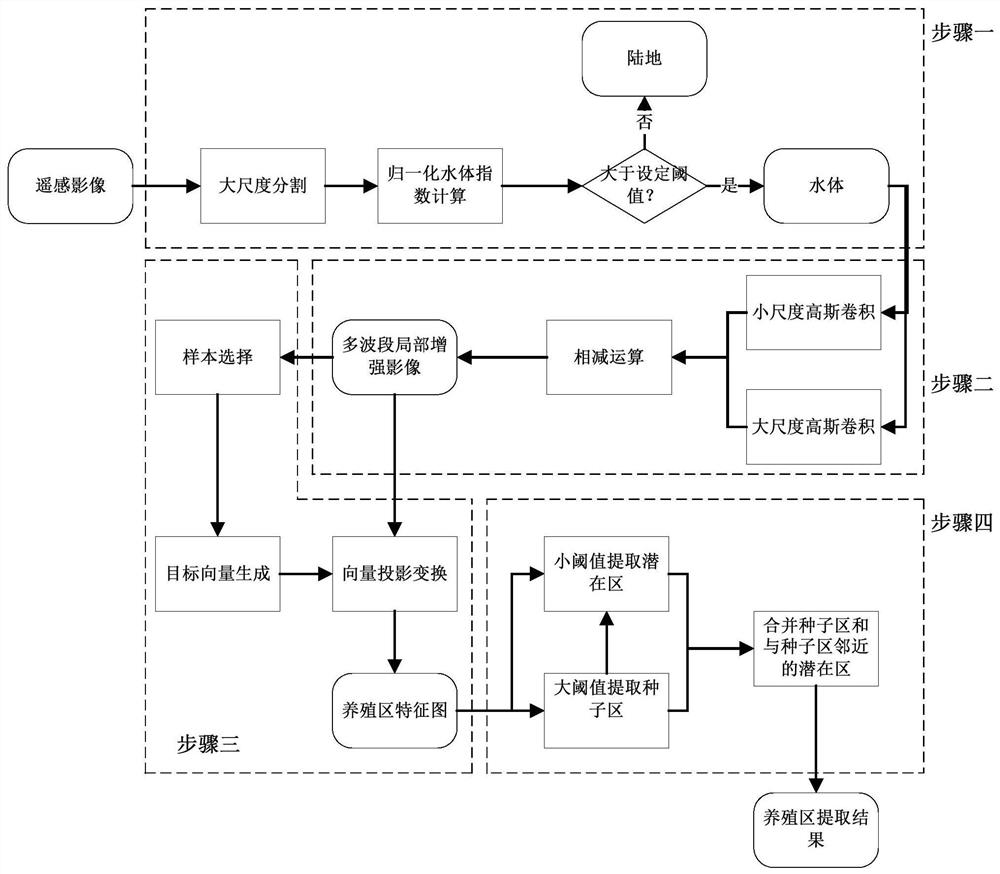
[0050] The specific technical solutions of the present invention will be further described below in conjunction with the accompanying drawings.

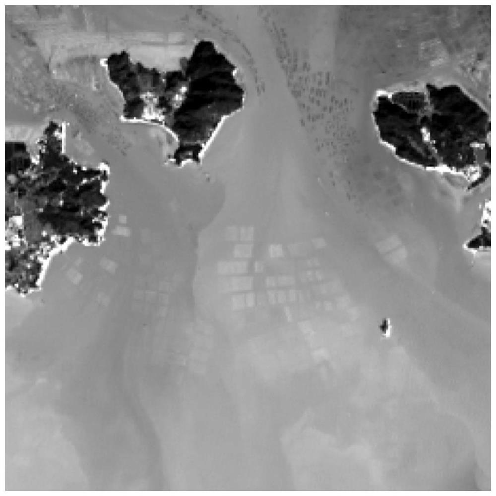
[0051] The multi-spectral resolution of the Landsat 8 remote sensing image processed by the method of the present invention reaches 30 meters. In this embodiment, the image data of the first 7 bands are taken, which are respectively the aerosol band (0.43-0.45 μm), the blue band (0.45- 0.51 μm), green band (0.53-0.59 μm), red band (0.64-0.67 μm), near infrared band (0.85-0.88 μm), short infrared band 1 (1.57-1.65 μm), short infrared band 2 (2.11- 2.29μm), the image size is 256 rows × 256 columns, as attached figure 2 shown.

[0052] Such as figure 1 As shown, the specific steps of the raft type mariculture extraction method based on high-resolution remote sensing images of the present invention are as follows:

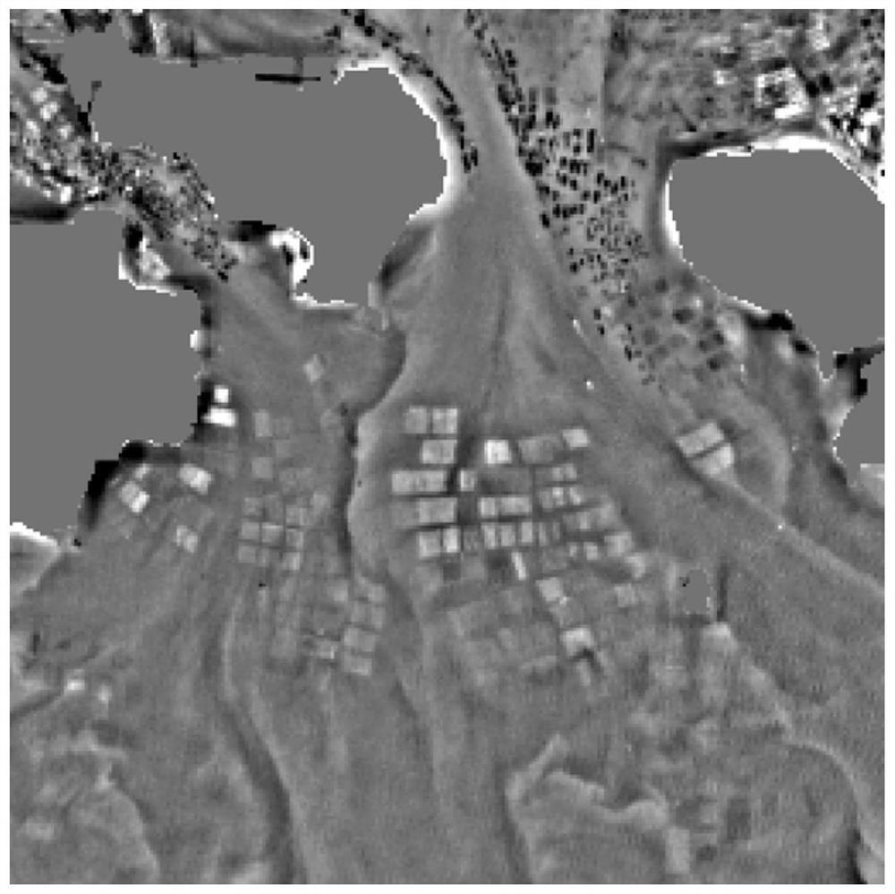
[0053] 1.1) Use the larger scale parameter S to segment the remote sensing image. The segmentation algorithm can use t...


PUM


Abstract

The invention provides a method for extracting aquaculture area in a satellite image based on scale space transformation, which is characterized in that it comprises the following steps: 1) on the basis of remote sensing image segmentation, using NDWI index to extract the water body area in the remote sensing image; 2) Carry out large-scale and small-scale spatial transformations for each band of the remote sensing image of the water body area, and subtract the results of the large-scale spatial transformation from the results of the small-scale spatial transformation to obtain a multi-band local enhancement image; 3) In the target area Select the sample set in , and perform vector projection transformation on the multi-band local enhanced image to obtain the characteristic map of the breeding area; 4) Observe the target area, determine the threshold, and extract the breeding area from the characteristic map of the breeding area. The method for extracting marine aquaculture areas of the present invention uses the cross-scale calculation mechanism in the image scale space, on the basis of utilizing full-band vector projection transformation, and realizes high-precision extraction of various types of aquaculture areas in satellite remote sensing images through a double-threshold method.

Description

technical field [0001] The invention belongs to the technical field of digital image processing, in particular to a method for extracting marine breeding areas in satellite images based on scale space transformation. Background technique [0002] Maritime farming provides humans with a large amount of food and promotes coastal economic benefits, but it also brings serious environmental problems. Timely and accurate acquisition of the spatial distribution information of mariculture is of great significance to the management of the development of mariculture and early warning of disasters such as typhoons and storm surges. Satellite remote sensing data has a wide monitoring range, short acquisition time, and rich ground object information, which can monitor these breeding information more macroscopically and quickly. Therefore, the development of satellite remote sensing to obtain mariculture extraction technology can provide objective, accurate and timely spatial distributio...

Claims


Application Information

Patent Timeline
Patent Type & Authority Patents(China)
IPC IPC(8): G06T7/11G06T5/50G06T3/00
CPCG06T3/005G06T5/50G06T2207/10032G06T2207/30181G06T7/11
Inventor 王志华杨晓梅刘岳明
Owner INST OF GEOGRAPHICAL SCI & NATURAL RESOURCE RES CAS
Why Eureka
Try Eureka