Urban road network shortest path acquisition method based on angle limitation and bidirectional search

An urban road network and two-way search technology, applied in the field of navigation optimization of the existing urban road network, can solve the problem of reducing the timeliness matching degree of route search in the navigation process, affecting the driver's travel experience, and the utilization efficiency of the urban road network. Direction and other issues to achieve the effect of improving efficiency, driving process efficiency, and improving navigation efficiency

Active Publication Date: 2021-06-18
HEFEI UNIV OF TECH
View PDF12 Cites 6 Cited by
  • Summary
  • Abstract
  • Description
  • Claims
  • Application Information

AI Technical Summary

Problems solved by technology

[0003] In the current urban road network, roads of various grades (express roads, main roads, secondary roads, and branch roads) are intertwined, and road grade factors seriously affect all aspects of the navigation itinerary. The current navigation products are often not effective in the navigation process. Using this factor to improve the timeliness of the navigation process seriously affects the driver's travel experience and the utilization efficiency of the urban road network.
In addition; in the path search stage of the specific navigation process, the existing path search methods are often based on real-time road network information to carry out path search in a single direction from the start point to the end point in the global scope. This path search method does not take into account The directionality of the driver's driving in the navigation reduces the timeliness of the route search in the navigation process and the degree of matching with the driver's travel intention

Method used


Image

  • Urban road network shortest path acquisition method based on angle limitation and bidirectional search
  • Urban road network shortest path acquisition method based on angle limitation and bidirectional search
  • Urban road network shortest path acquisition method based on angle limitation and bidirectional search

Examples


Embodiment Construction

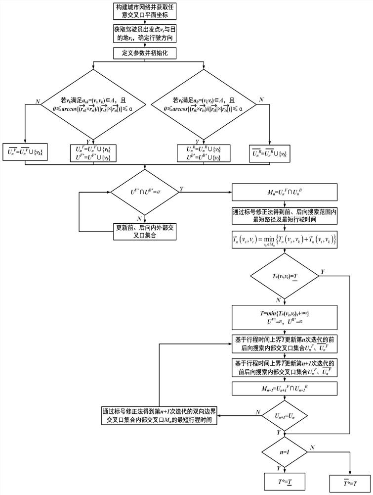
[0074] In this embodiment, since the method for obtaining the shortest path of the present invention always searches for paths from front to back in two local areas with similar Half-Ellipse boundaries, the method for obtaining the shortest path of the present invention can be referred to as Two-way E* algorithm. Specifically, if figure 1 As shown, a method of obtaining the shortest path of urban road network based on angle restriction and two-way search is carried out as follows:

[0075] Step 1: Construct the urban road network and obtain the plane coordinates of any intersection;

[0076] Obtain real-time road network data and obtain the urban road network G=(V,A), where V represents the set of intersections, and V={v 1 ,v 2 ,...,v q ,...,v Q},v q Indicates the qth intersection, q=1,2,...,Q; Q indicates the total number of intersections, A indicates the set of road sections between intersections, and A={a ij =(v i ,v j )|i,j=1,2,...Q}, a ij Denotes the i-th inters...


PUM


Abstract

The invention discloses an urban road network shortest path acquisition method based on angle limitation and bidirectional search. The method comprises the following steps: 1, constructing an urban network according to real-time road condition information; 2, introducing a forward search boundary internal and external intersection set UnF, a backward search boundary internal and external intersection set UnB, a bidirectional boundary intersection set Mn and travel time upper and lower bounds T; 3, updating the intersection sets UnF and UnB inside and outside the forward and backward search boundaries of the sets; 4, obtaining the shortest path from the starting point to the destination point through the intersections in the intersection set Mn of the bidirectional boundaries by a label correction method; and 5, if the travel time of the shortest path is equal to the lower bound T of the travel time or the intersection set UnF and UnB in the forward and backward search boundaries are not updated any more, acquiring the shortest path, or otherwise, returning to the step 3. According to the method, angle limitation and bidirectional search are added in navigation of the urban road network, so that the search range is effectively narrowed; therefore, the navigation efficiency is improved, and a faster and more efficient driving path can be provided.

Description

technical field [0001] The invention belongs to the field of navigation optimization of the existing urban road network, in particular to a method for obtaining the shortest path of the urban road network based on angle limitation and bidirectional search. Background technique [0002] With the development of society, Internet-based traffic navigation has brought more and more convenience to users. Users can input their own starting point and destination at the beginning of navigation, and then they can obtain the route automatically planned by navigation products. However, as the number of cars in cities gradually increases, the construction of road networks is relatively lagging behind, traffic resources are wasted, and travel efficiency is low. Loss. Therefore, it is necessary to study a route navigation method to improve the travel level and the utilization rate of the urban road network. With the development of GPS, network technology, and computer technology, the con...

Claims


Application Information

Patent Timeline
IPC IPC(8): G08G1/0968
CPCG08G1/096805G08G1/096833
Inventor 丁建勋冯战雨江宇鹏周润东丁卫东满忠运查菲菲夏力徐小明龙建成
Owner HEFEI UNIV OF TECH
Why Eureka
Try Eureka