Terminal positioning method, terminal and positioning server
A positioning server and terminal positioning technology, applied in satellite radio beacon positioning systems, instruments, measuring devices, etc., can solve problems such as poor accuracy, inaccurate positioning, and inability to update in real time, and achieve the effect of improving accuracy
- Summary
- Abstract
- Description
- Claims
- Application Information
AI Technical Summary
Problems solved by technology
Method used
Image
Examples
Embodiment 1
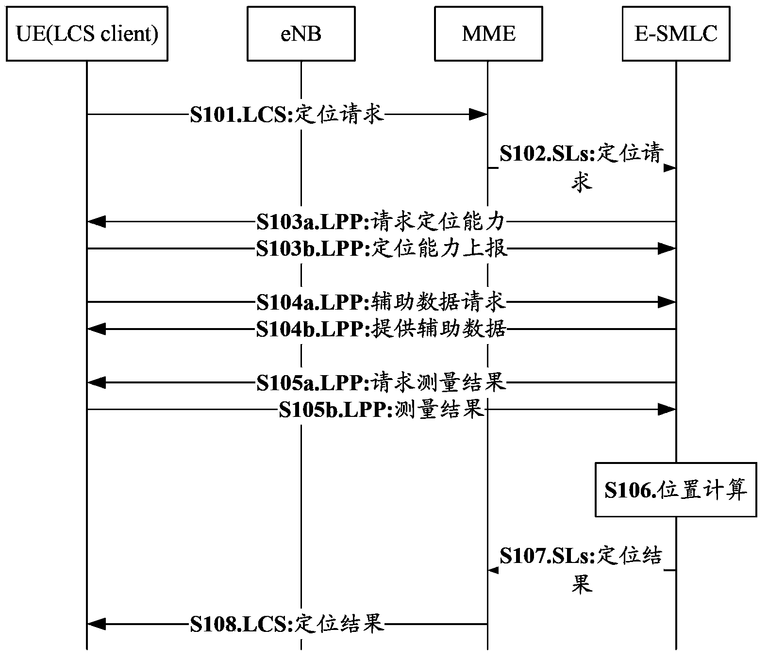
[0252] In the LTE system, a case where the UE acts as a positioning initiator is taken as an example for illustration.
[0253] The flowchart of this embodiment is as figure 1 As shown, but in step S103b of the process, when the terminal reports the positioning capability, it can indicate the terminal's support for using pseudolite for positioning, and can also report which frequencies it supports for receiving satellite signals. In steps S104a and S104b, when the terminal requests the positioning server to provide assistance data, if the terminal supports pseudolite positioning, it needs to report the identity of the serving cell where it is located. The positioning server judges whether the location of the terminal is indoors or high-rise densely populated area according to the terminal's assistance data request information and the information of its cell. The auxiliary data of the pseudolite also needs to provide the auxiliary data of the pseudolite. For example: In addit...
Embodiment 2
[0263] In the UMTS system, there is an independent positioning server, that is, the positioning server is the SAS.
[0264] Such as Figure 7 as shown, Figure 7 In addition to step S500, all the other steps are related to Figure 5 Similarly, in this embodiment, during the terminal access to the network, step S500 is performed: the terminal reports its own capabilities, and when reporting its own capabilities, the terminal will report the terminal's support for using pseudolite positioning. If the terminal is capable of using pseudolite positioning, it may report that it supports pseudolite positioning. Further, in step S500, it may also report which satellite frequencies it supports. SRNC receives the information and saves it. When the terminal needs to be positioned, SRNC will initiate a positioning initialization request to SAS, and report the pseudolite positioning supported by the terminal and the information of the serving cell where the terminal is located, so that S...
Embodiment 3
[0266] In the UMTS system, the SRNC serves as a location server to complete location-related functions.
[0267] Such as Figure 8 as shown, Figure 8 In addition to step S400, all the other steps are related to Figure 4 Similarly, in this embodiment, when the terminal communicates with the positioning server, step S400 is performed: the terminal reports its own capabilities, and the reported capabilities include positioning capabilities, that is, the terminal supports the use of pseudolite positioning, if It supports the use of pseudolite positioning, and at the same time reports the frequency point information of the supported satellite signal reception. According to the service cell information of the terminal and the ability of pseudolite positioning, the SRNC judges whether it is indoor, whether it is a high-rise dense area, whether there is a pseudolite deployment, etc., and then judges whether it is necessary to provide auxiliary data of pseudolite . When it is det...
PUM
 Abstract
Description
Claims
Application Information
 - R&D
- Intellectual Property
- Life Sciences
- Materials
- Tech Scout
- Unparalleled Data Quality
- Higher Quality Content
- 60% Fewer Hallucinations
Browse by: Latest US Patents, China's latest patents, Technical Efficacy Thesaurus, Application Domain, Technology Topic, Popular Technical Reports.
© 2025 PatSnap. All rights reserved.Legal|Privacy policy|Modern Slavery Act Transparency Statement|Sitemap|About US| Contact US: help@patsnap.com


