
Location of wireless mobile terminals

a mobile terminal and wireless technology, applied in the field of wireless mobile terminal location, can solve the problems of gps having a number of limiting factors, too much of an operational burden to maintain, and too expensive to deploy high-accuracy technologies, so as to minimize the sum of costs

Inactive Publication Date: 2011-02-10
WAVEMARKET
View PDF99 Cites 169 Cited by
  • Summary
  • Abstract
  • Description
  • Claims
  • Application Information

AI Technical Summary

Benefits of technology

Certain embodiment of the present disclosure provide systems, methods, process-readable media and / or devices which can service users across multiple networks, without requiring information from the operators of those networks, in which the information concerning those networks is collected and maintained in a current state efficiently and with rapid response to any changes in the network configuration. In certain aspects, it may be possible to combine the disclosed systems, methods, process-readable media and / or devices and use in combination with information from the operators of the networks.
In certain embodiments, methods, systems, processor-readable media and / or devices in accordance with the present disclosure are characterized by the steps of receiving a report from a mobile radio terminal, wherein the report includes at least one measurement of at least one radio network parameter from a first wireless network transmitter; estimating a location for the mobile radio terminal based on the report; estimating a set of characteristics for the first wireless network transmitter based on the at least one measurement of at least one radio network parameter; storing the set of characteristics for the first wireless network transmitter; and updating a list of tasking information with a quality of the set of characteristics for the first wireless network transmitter. In certain aspects the disclosed methods, systems, processor-readable media and / or devices may include communicating the list of tasking information to a plurality of mobile radio terminals. In certain aspects, not relying on the estimated location of the mobile radio terminal may lead to several advantages in performance and / or quality control of the network learning collection process.

Problems solved by technology

One was that the some of the technologies developed to achieve high accuracy turned out to be too expensive to deploy or too much of an operational burden to maintain.
Another problem was that the new technologies required new handsets which created a problem launching the services.
Another problem was that the value chain was too complex.
However, GPS has a number of limiting factors.
For example, GPS is only available in a limited number of cellular handsets, thereby limiting its availability.
Further, GPS typically performs poorly indoors due to the reliance on line of sight for satellite fixes.
Additionally, GPS has a high latency which can frustrate some users who don't want to wait for a GPS lock.
In the past some attempts have been made to collect this information in order to make cellular based location publically accessible however none of these achieved sufficient coverage or quality to support high quality services.
In the emerging Mobile Web 2.0 services ecosystem this represents a significant impediment because fewer and fewer applications can be viable if operated only with a single MNO or on a small number of devices.
Additionally the emerging mobile Internet ecosystem enabled by recent advances in device UI capabilities, wireless connections speeds and availability of content for mobile consumption is being held back because the majority of the independent software vendors and content providers cannot afford to negotiate individual deals with all the carriers to make location information available.
Application developers seeking to use location information across multiple networks face another challenge even where operators do make location information available.
The differences between the location technologies used by the different operators make it difficult to abstract across the different networks to obtain a consistent level of functionality and performance.
Another challenge for the platform is the continual evolution of the wireless networks as operators optimize the networks and add capacity.
Differences between countries also mean that services which otherwise operate on a global basis, cannot access location information on a global basis.
Providing a consistent level of service to users in this environment is also difficult.
Even if each of the providers were willing to make their location information available, the differences in the systems (for instance Wi-Fi & cellular) mean that it may be difficult for an application developer to develop against a common location capability set.
In practice however the limitations of GPS necessitate assistance information (e.g., A-GPS) which typically requires coarse cellular data to bootstrap the process.
This again may be hard to achieve without negotiating with all the MNOs.
Some providers (Nokia for example) have sought to provide a common assistance service however currently it's coverage is limited to certain carriers only in limited regions.
A fundamental difficulty in getting coverage across all radio networks is that the radio network configuration information is proprietary to the mobile network operator (MNO), and embodies proprietary technical and commercial information.
MNOs are typically unwilling to provide this information to a third party for aggregation unless they can receive a revenue stream.
Having to source databases from different MNOs in different areas and countries to support a wide variety of applications leads to a very complex value chain and to date has been a commercial obstacle.
The result is that despite the significant social and commercial benefits that could accrue from a common wireless location service, such a service has not been available until the recent release of services such as Google Maps for Mobile and particularly the feature within known as My Location.
Despite the advances in such systems however there remain significant limitations for users.
For example, one such limitation is the slow response to changes in the configuration of the radio network.
For example it has been observed that a change in the configuration of some 3G cells in a region of London resulted in a substantial loss of coverage for a period lasting at least 12 days.

Method used


Image

  • Location of wireless mobile terminals
  • Location of wireless mobile terminals
  • Location of wireless mobile terminals

Examples


Embodiment Construction

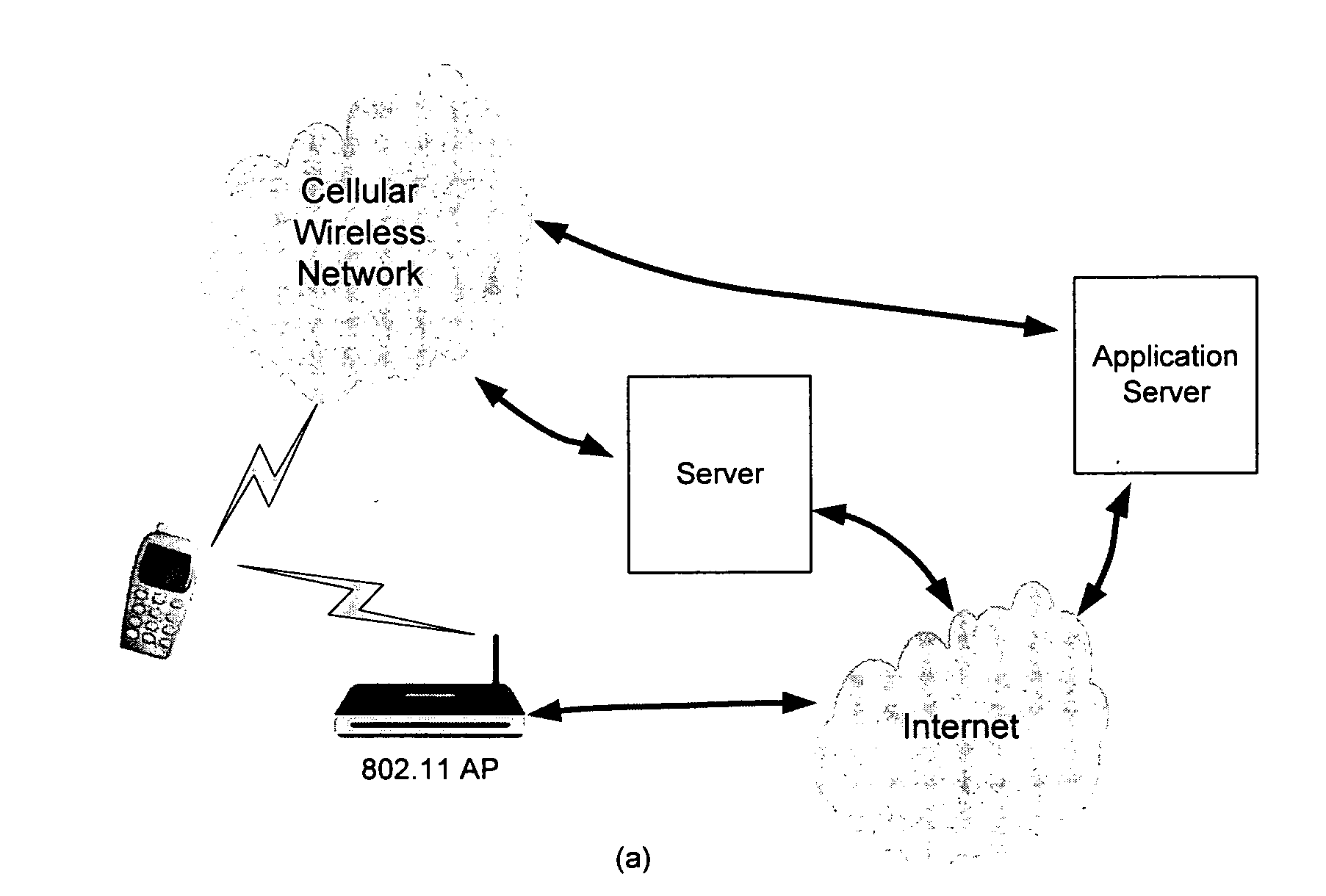
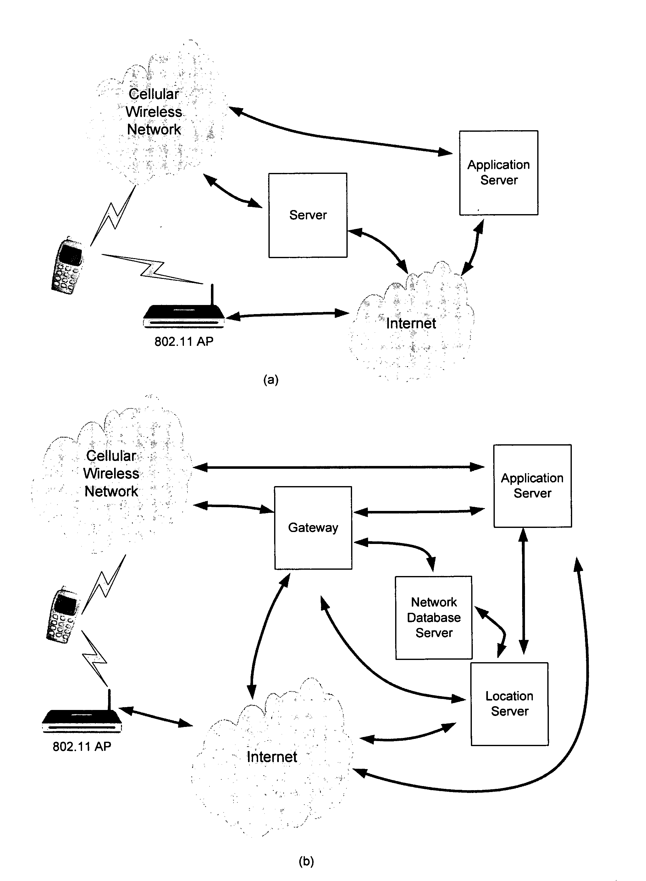
Certain embodiments of the present disclosure will now be described in detail, examples of which are illustrated in the accompanying drawings. The examples and embodiments are provided by way of explanation only and are not to be taken as limiting to the scope of the inventions. Furthermore, features illustrated or described as part of one embodiment may be used with one or more other embodiments to provide a further new combination. It will be understood that the present inventions will cover these variations and embodiments as well as variations and modifications that would be understood by the person skilled in the art

In accordance with certain embodiments, the term “aggregating” is used to describe the combined process of collecting and then maintaining information characterizing one or more wireless transmitters in a network. Other synonymous terms used in the description include discovering and updating.

In accordance with certain embodiments, the terms “wireless network access...


PUM


Abstract

Methods, systems, processor-readable media, and devices for collecting information pertaining to the configuration of one or more wireless networks and using this information in turn to estimate the location of mobile wireless devices associated with those networks are disclosed. Also disclosed are methods, systems, processor-readable media, and devices for discovering and / or maintaining wireless transmitter characteristics corresponding to one or more wireless networks. Also disclosed are methods, systems, processor-readable media, and devices for aggregating wireless network transmitter characteristics from a plurality of wireless network transmitters. The present disclosure can be used across multiple networks, without requiring information from the operators of those networks, in which the information concerning those networks is collected and maintained in a current state efficiently and with rapid response to changes in the network configuration.

Description

FIELDCertain embodiments of the present disclosure are directed to providing systems, methods and devices for collecting information pertaining to the configuration of one or more wireless networks and using this information in turn to estimate the location of mobile wireless devices associated with those networks.BACKGROUNDThe use of location information has been considered in mobile services for many years. After a period of hype, so-called location based services (LBS) suffered a downturn for a combination of reasons. One was that the some of the technologies developed to achieve high accuracy turned out to be too expensive to deploy or too much of an operational burden to maintain. Another problem was that the new technologies required new handsets which created a problem launching the services. Another problem was that the value chain was too complex.Location information for a wireless device can be obtained from at least two sources. One source is via a global positioning syst...

Claims


Application Information

Patent Timeline
IPC IPC(8): H04W64/00
CPCG01S5/0236H04W64/003H04W64/00H04W16/18
Inventor DAVID, MALCOLMDRANE, CHRISTOPHE RIDGWAYBROWN, STEPHEN FRANKSCOTT, CRAIG ANDREW
Owner WAVEMARKET
Learn More