Sea surface adaptive imaging method based on SAR (Synthetic Aperture Radar) sub-view analysis

An imaging method and self-adaptive technology, applied in the direction of reflection/re-radiation of radio waves, instruments, measuring devices, etc., can solve problems such as interference, high intensity, affecting imaging quality, etc., to achieve effective separation, suppression of interference and sea clutter , the effect of improving the signal-to-noise ratio

Pending Publication Date: 2022-08-05
苏州空天信息研究院
View PDF0 Cites 0 Cited by
  • Summary
  • Abstract
  • Description
  • Claims
  • Application Information

AI Technical Summary

Problems solved by technology

The RD algorithm is the first imaging processing algorithm developed for civil spaceborne SAR, but there are two shortcomings: first, when using a longer kernel function to improve the accuracy of range migration correction, the calculation amount is large; second, the second distance The dependence of compression on azimuth frequency is difficult to solve, which limits its processing accuracy for some large oblique viewing angles and long aperture SAR
When the blur energy is strong, a large number of false targets will be generated, which affects the misjudgment of the real target in the image
Since the amplitude of the sea surface image is much lower than that of the land image, the azimuth ambiguity has a more serious impact on the marine application than the land application, especially in the marine monitoring of the coastal zone and the junction of land and sea, coastal artificial buildings, breeding areas, ships Compared with the ocean background, the fuzzy signal generated by the target with strong backscattering is still very strong, which seriously affects the subsequent application of the ocean background image.
In addition, ocean background SAR images are often interfered by sea clutter, which affects the imaging quality

Method used

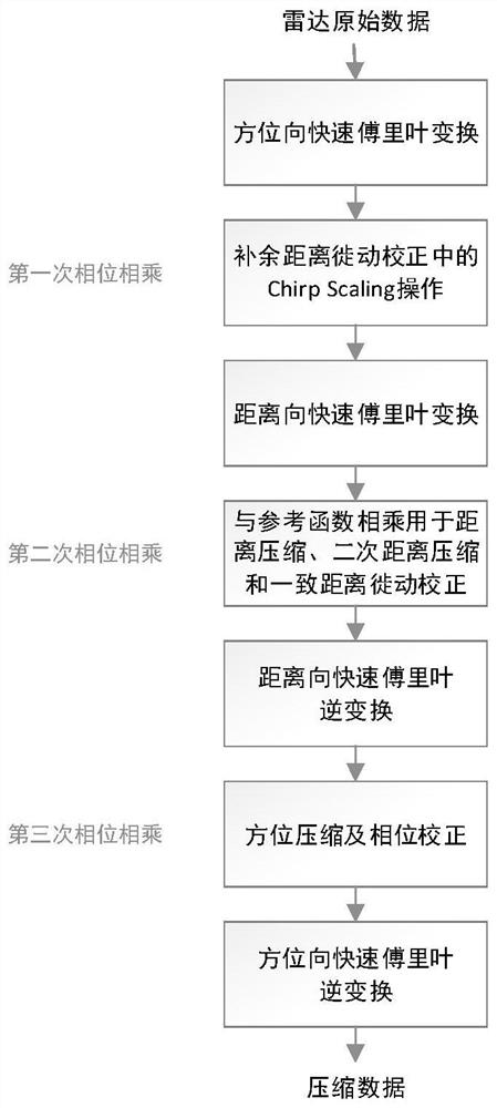

Image

  • Sea surface adaptive imaging method based on SAR (Synthetic Aperture Radar) sub-view analysis
  • Sea surface adaptive imaging method based on SAR (Synthetic Aperture Radar) sub-view analysis
  • Sea surface adaptive imaging method based on SAR (Synthetic Aperture Radar) sub-view analysis

Examples


Embodiment

[0049] In order to verify the effectiveness of the scheme of the present invention, the following experiments were carried out.

[0050] 2 slices were cropped from the CS imaging results of the GF-3 satellite hyperfine strip ocean scene ( Figure 4 In (a) and (c)), the slice size is 1200 by 1200 pixels. The pixel spacing in the range and azimuth directions is 1.124m and 1.713m, respectively. The slices contain ship, azimuth blur, and sea clutter signals. Through the treatment of the method of the present invention, obtain such as Figure 4 Results of (b) and (d). From the visual effect, the azimuth fuzzy signal is suppressed, and the ship target is more prominent.

[0051] In order to quantitatively verify the advantages of the present invention, the strongest scattering points (S1, S2, S3, S4) of each ship and the strongest points (A1, A2, A4) of point-like azimuth fuzzy signals were selected from the two slices respectively. , A5), distributed azimuth fuzzy signal area A3...


PUM


Abstract

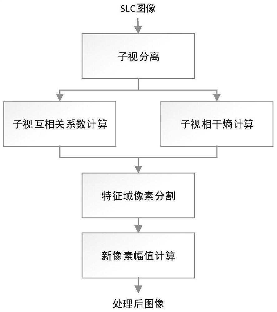
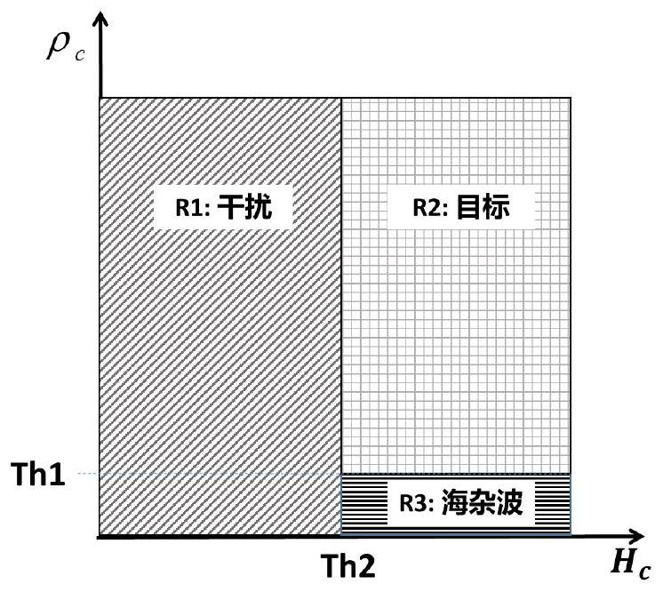
The invention provides a sea surface self-adaptive imaging method based on SAR (synthetic aperture radar) sub-view analysis, which comprises the following steps of: converting an SAR single-view complex image into an azimuth frequency domain, performing window function weighted reverse correction according to the type of an azimuth added window function during imaging, averagely dividing an azimuth Doppler bandwidth into a left part and a right part, azimuth inverse Fourier transform is carried out on the echoes only containing half frequency spectrums to obtain a left sub-aperture image and a right sub-aperture image; calculating a sub-view cross correlation coefficient according to the left and right sub-aperture images; calculating a sub-visual coherence entropy according to the left and right sub-aperture images; dividing a two-dimensional feature space formed by the sub-view cross correlation coefficient and the sub-view coherence entropy into an interference area, a target area and a sea clutter area, and segmenting pixels according to the divided areas; and calculating the pixel amplitude of each sub-region. According to the invention, through reprocessing of the SAR image, azimuth ambiguity and sea clutters in the marine background SAR image are suppressed, and the SAR imaging quality under the marine background is improved.

Description

technical field [0001] The invention relates to the field of SAR image processing, in particular to a sea surface adaptive imaging method based on SAR sub-view analysis. Background technique [0002] Synthetic Aperture Radar (SAR) is a microwave active imaging radar that can achieve two-dimensional high resolution. The radar emits electromagnetic waves with a large time-bandwidth product, and then obtains a large resolution in the distance direction through pulse compression. High resolution in azimuth is achieved using the principle of synthetic aperture. With the improvement of resolution and the generation of new imaging modalities, the requirements for SAR imaging processing algorithms are becoming more and more complex. [0003] The classical SAR imaging algorithms mainly include RD algorithm, CS algorithm and so on. The RD algorithm is the first imaging processing algorithm developed for civil spaceborne SAR, but it has two shortcomings: first, when a longer kernel ...

Claims


Application Information

Patent Timeline
Patent Type & Authority Applications(China)
IPC IPC(8): G01S13/90G01S7/41
CPCG01S13/9021G01S7/41
Inventor 金燕仇晓兰台宪青
Owner 苏州空天信息研究院
Why Eureka
Try Eureka