
Large-area soil heavy metal detection and spatial and temporal distribution characteristic analysis method and system

A feature analysis, time-space distribution technology, applied in soil material testing, thermal excitation analysis, material excitation analysis, etc., can solve the problems of low analysis efficiency, small sampling point area, representative analysis results, insufficient accuracy and trend, etc. Achieving the effect of high analysis precision

Inactive Publication Date: 2021-06-18
CENT SOUTH UNIV
View PDF11 Cites 4 Cited by
  • Summary
  • Abstract
  • Description
  • Claims
  • Application Information

AI Technical Summary

Problems solved by technology

According to media reports, since the 20th century, incidents of heavy metal pollution and health damage in some urban agglomerations in China have occurred frequently. Failed to conduct surveys and researches on large areas across cities, such as urban agglomerations, especially the time dimension of large areas
In the prior art, during the sampling, detection and analysis of soil heavy metals, due to the small sampling area, limited number of samples, and inconsistent data format, it is often not directly applicable to the research of large areas such as urban agglomerations; the existing research methods are often incomplete. The spatial distribution and temporal changes covering the entire large area lead to insufficient representativeness, accuracy, and trend of the analysis results, and it is impossible to further analyze and evaluate the soil environmental quality in large areas of urban agglomerations and formulate targeted prevention and control programs.
[0004] At the same time, most of the current analysis, evaluation and result output of soil environmental quality are still done manually by field experts, using their professional skills to analyze and judge manually, so there are low data processing capabilities, low analysis efficiency, The analysis results have some shortcomings such as subjectivity, and new technologies such as machine learning cannot be applied to related fields. The automation of the analysis process is low, and the repeatability of the process and the verifiability of the method are poor.

Method used


Image

  • Large-area soil heavy metal detection and spatial and temporal distribution characteristic analysis method and system
  • Large-area soil heavy metal detection and spatial and temporal distribution characteristic analysis method and system
  • Large-area soil heavy metal detection and spatial and temporal distribution characteristic analysis method and system

Examples


Embodiment

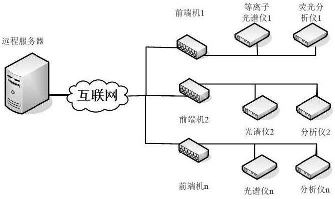
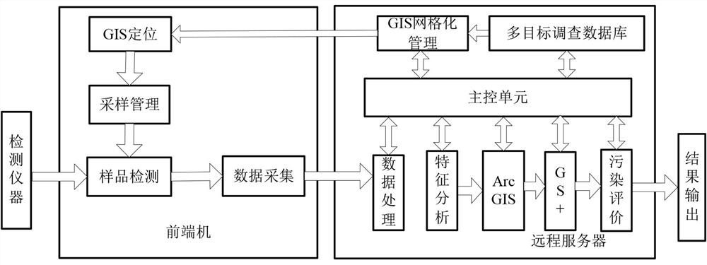
[0096] See attached Picture 1-1 5(d), the method for detecting heavy metals in large-area soil and analyzing the characteristics of time-space distribution provided by the embodiment of the present invention includes the following steps:

[0097] 1) Construct an analysis model for the spatial distribution of various heavy metal elements in large areas such as urban agglomerations, and program the model and pre-store it in the corresponding module of the remote server; specifically, the multivariate stepwise regression model in geospatial regression is used to analyze the soil in soil. The content of Hg and Pb, and the content of As and Cd in the soil were analyzed by least squares regression model;

[0098] 11) Select 80% of the composite detection data collected in a large area and import it into a remote server for the establishment of a regression model for geographic spatial distribution analysis, using the correlation between soil variables and other influencing factors ...

specific Embodiment 1

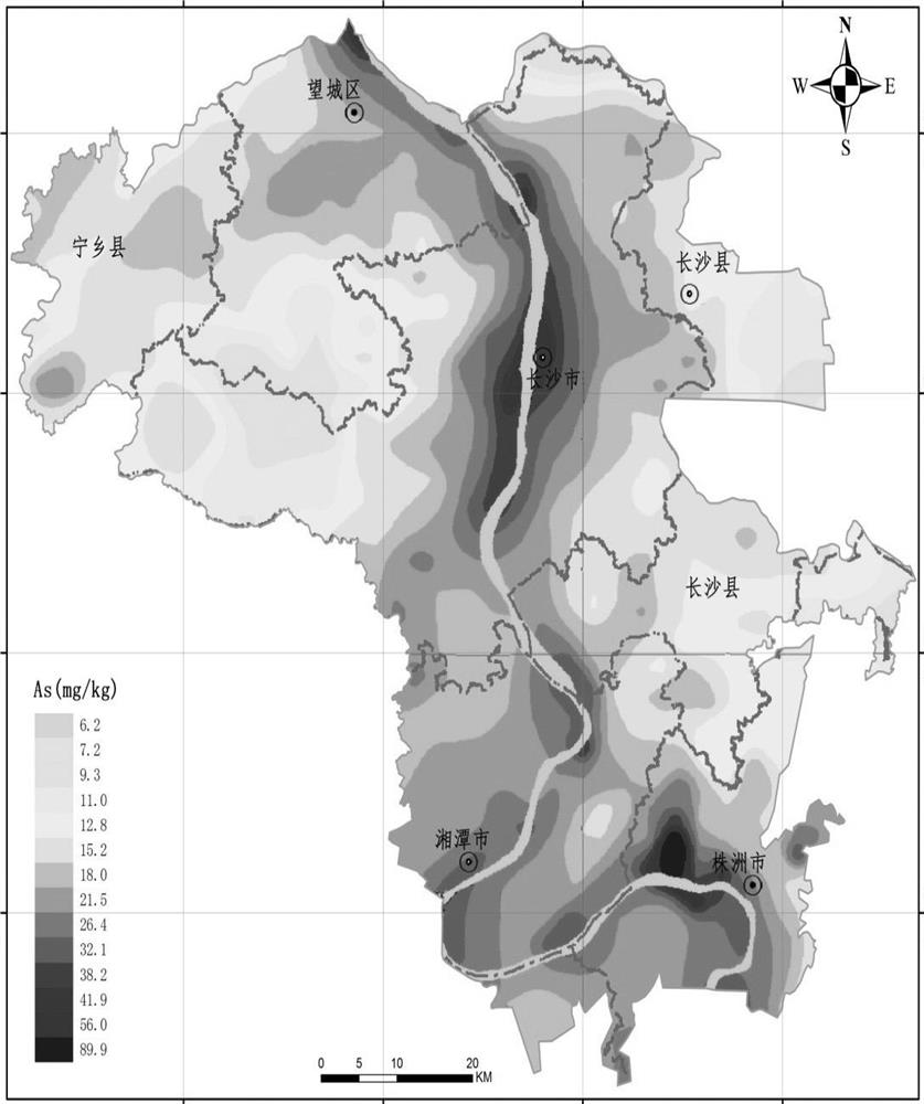
[0143] In the embodiment of the present invention, the large area of ​​the Changzhou-Zhuzhou-Tan urban agglomeration in Hunan Province is taken as the research object. Changsha is the central city of the Changzhou-Zhuzhou-Tan urban agglomeration and the provincial capital of Hunan Province. Important industrial base and traffic arteries. As the core area of ​​the urban agglomeration, the three cities of Changzhou, Zhuzhou and Xiangtan are distributed in a "Y" shape along the Xiangjiang River, with a distance of about 40 km between them. From the perspective of physical and geographical conditions, the three cities have the same geological background, which better guarantees the rationality of the overall evaluation of the study area; secondly, the topography and developed water system in the study area play a certain role in the diffusion of elements; the third is Changzhutan. The industrial and agricultural development orientation of the three cities highlights the influence ...

specific Embodiment 2

[0185] The large-scale soil heavy metal detection and time-space distribution characteristic analysis method and system provided by the embodiment of the present invention are basically the same as in embodiment 1, the difference is that the remote server is also provided with soil heavy metal pollution status evaluation (i.e. Soil environmental quality assessment) module, based on the analysis data and analysis results of the spatial distribution characteristics, is used to evaluate the soil heavy metal pollution.

[0186] Soil environmental quality evaluation is actually a comprehensive evaluation of ecological geochemistry, which is generally carried out on the basis of regional background values, including soil primary environmental quality evaluation, soil environmental pollution evaluation, and soil resource quality evaluation. This study carried out environmental quality assessment on the distribution characteristics of soil heavy metal elements caused by land use and na...


PUM


Abstract

The invention discloses a large-area soil heavy metal detection and spatial and temporal distribution characteristic analysis method and system. The method comprises the following steps: 1) constructing an analysis model for spatial distribution of multiple heavy metal elements in a large area; 2) determining an analysis object; 3) sampling and detecting the urban surface soil in each gridding area; and 4) substituting the obtained sampling composite detection data into the analysis model, analyzing the soil heavy metal content and geographic information, and drawing a total content distribution diagram of the heavy metal elements. The system provided by the invention comprises a remote server, a plurality of front-end machines and terminal equipment which are mutually connected and communicated through a network. By constructing a new mathematical model, screening typical detection objects and comprehensively utilizing sampling point data and geochemical survey data, distribution characteristics of four elements of As, Cd, Hg and Pb in a large area are analyzed, the area coverage of an analysis result is complete, the accuracy is high, and the automation degree of the analysis process is high.

Description

technical field [0001] The invention relates to the technical field of soil heavy metal detection and geographical information analysis, in particular to a large-area soil heavy metal detection and time-space distribution characteristic analysis method and system. Background technique [0002] With the rapid development of urbanization in our country, more and more urban agglomerations with closely related regions, economies and cultures have emerged one after another. Urban agglomeration is the highest form of spatial organization in the mature stage of urban development. It refers to within a specific geographical range, generally centered on more than one megacity, composed of three or more major cities, and relying on developed transportation and communication infrastructure. The facility network forms an urban group with compact spatial organization, close economic ties, and ultimately a high degree of urbanization and integration. Urban agglomeration is a huge, multi-...

Claims


Application Information

Patent Timeline
IPC IPC(8): G01N33/24G01N1/28G01N21/73G01N21/64G06N3/08
CPCG01N33/24G06F16/9537G06F30/20G06F17/18G06F2111/10
Inventor 邱罗毛先成刘启波刘占坤
Owner CENT SOUTH UNIV
Learn More