System and method for measuring power image distance of transmission line by unmanned aerial vehicle

A technology for transmission lines and unmanned aerial vehicles, applied in the field of unmanned aerial vehicles, can solve the problems of high operation cost, influence of laser beam reflection, interference and influence of measurement methods, etc., and achieve the effect of high accuracy

Active Publication Date: 2021-03-19
STATE GRID JIANGSU ELECTRIC POWER CO LTD TAIZHOU POWER SUPPLY BRANCH +1
View PDF7 Cites 4 Cited by
  • Summary
  • Abstract
  • Description
  • Claims
  • Application Information

AI Technical Summary

Problems solved by technology

[0003] The measurement method of the traditional handheld laser rangefinder is susceptible to interference and influence of human and environmental factors
For example, in areas with many sunny days, the infrared rays contained in the strong sunlight will cause large measurement errors in the handheld laser rangefinder used outdoors; in rainy and snowy weather conditions, rain will also affect the reflection of the laser beam, resulting in The measuring equipment cannot work normally; at the same time, the inaccurate target positioning caused by humans will also bring errors to the measurement
The transmission line measurement method based on the laser scanner has high precision and is less affected by human factors, but it is also affected by rain and snow, and the operation cost of this method is high and the amount of data is large
For the above two measurement methods, there is still the same deficiency, that is, due to manpower and actual field operation costs, it is impossible to implement all-weather and all-day transmission line monitoring. When the actual operation scene is consistent with the original data acquisition scene When the original data obtained by the above two methods has a certain reference value and validity, but when there is a difference between the actual measurement scene and the scene at the time of data collection, for example, a new target object appears in the scene, it is difficult to achieve based on the original data. Distance measurement between new objects and transmission lines

Method used


Image

  • System and method for measuring power image distance of transmission line by unmanned aerial vehicle
  • System and method for measuring power image distance of transmission line by unmanned aerial vehicle
  • System and method for measuring power image distance of transmission line by unmanned aerial vehicle

Examples


Embodiment 1

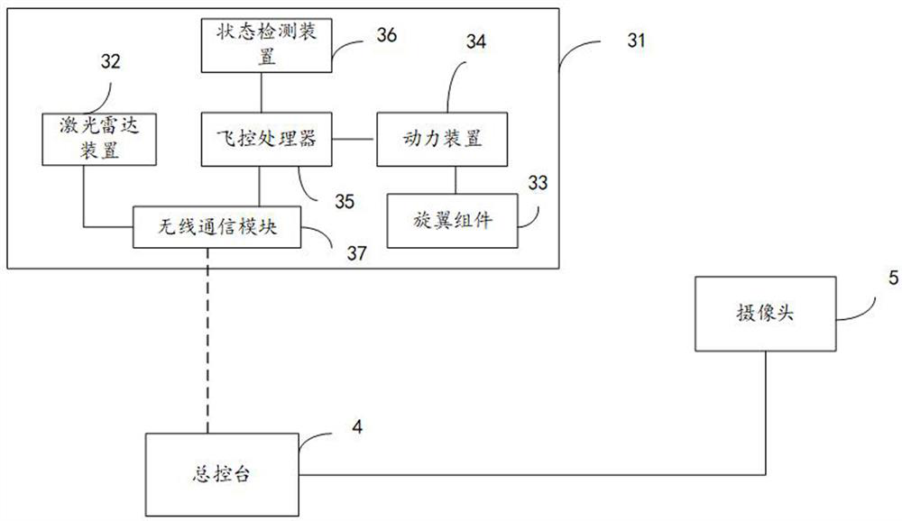
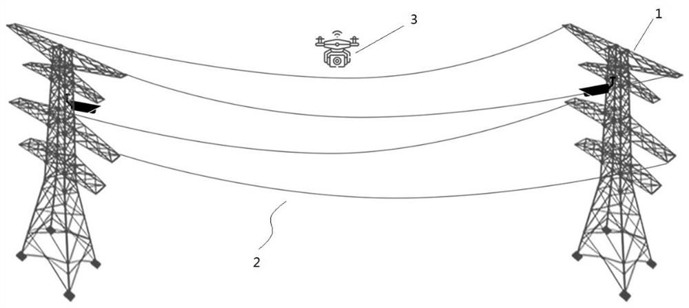
[0045] refer to figure 1 and figure 2 , in some embodiments, a system for measuring the image distance of transmission lines by drones is provided, the transmission lines include a plurality of power towers 1 and transmission line corridors 2 between adjacent power towers, the system includes wireless Man-machine 3, master console 4 and multiple cameras 5;

[0046] The camera 5 is fixed on the power pole 1, and is used to collect two-dimensional image data of the transmission line corridor;

[0047] The UAV 3 includes a body 31, a laser radar device 32, a rotor assembly 33, a power unit 34, a flight control processor 35, a state detection device 36 and a wireless communication module 37;

[0048]The state detection device 36 is used to obtain its own positioning information and collect the distance information between the unmanned aerial vehicle and the ground and send it to the flight control processor 35, and the flight control processor 35 is used to generate a control s...

Embodiment 2

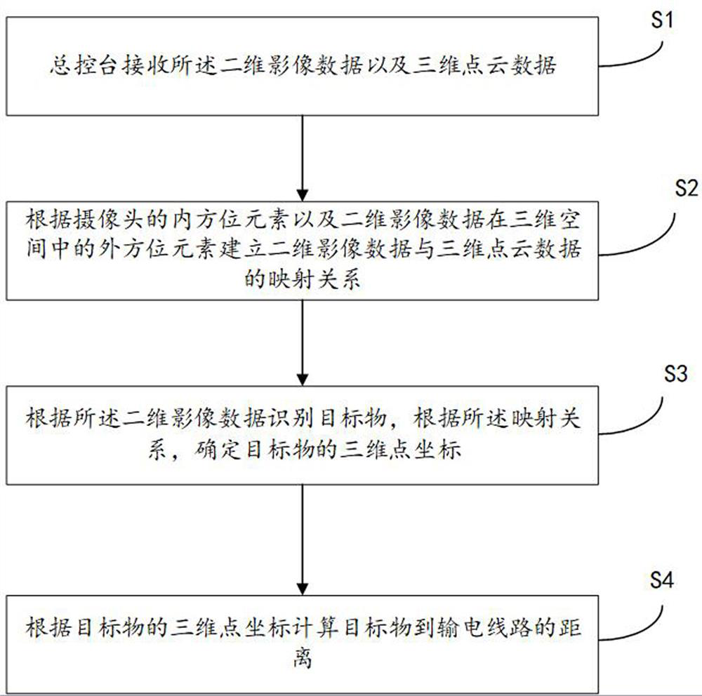
[0057] refer to image 3 , the present embodiment provides a method for measuring the image distance of a transmission line using the system described in Embodiment 1, comprising the following steps:

[0058] S1. The master console receives the two-dimensional image data and three-dimensional point cloud data;

[0059] S2. Establish a mapping relationship between the two-dimensional image data and the three-dimensional point cloud data according to the inner orientation elements of the camera and the outer orientation elements of the two-dimensional image data in the three-dimensional space;

[0060] S3. Identify the target object according to the two-dimensional image data, and determine the three-dimensional point coordinates of the target object according to the mapping relationship;

[0061] S4. Calculate the distance from the target object to the transmission line according to the three-dimensional point coordinates of the target object.

[0062] Specifically, in S1, th...

Embodiment 3

[0091] refer to Figure 4 , the present embodiment provides a device for measuring the image distance of a power transmission line by an unmanned aerial vehicle, including:

[0092] A receiving module 301, configured to receive the two-dimensional image data and three-dimensional point cloud data;

[0093] A relationship determination module 302, configured to establish a mapping relationship between two-dimensional image data and three-dimensional point cloud data according to the inner orientation elements of the camera and the outer orientation elements of the two-dimensional image data in three-dimensional space;

[0094] Coordinate determination module 303, configured to identify the target object according to the two-dimensional image data, and determine the three-dimensional point coordinates of the target object according to the mapping relationship;

[0095] The distance calculation module 304 is configured to calculate the distance from the target to the transmissio...


PUM

PropertyMeasurementUnit
Widthaaaaaaaaaa

Abstract

The invention discloses a system and method for measuring the image distance of a power transmission line through an unmanned aerial vehicle, wherein the system comprises the unmanned aerial vehicle,a main console and a plurality of cameras, and the plurality of cameras are fixed on a power pole tower and are used for collecting the two-dimensional image data of a corridor of the power transmission line. The unmanned aerial vehicle comprises a vehicle body, a laser radar device, a rotor wing assembly, a power device, a flight control processor, a state detection device and a wireless communication module; the laser radar device is used for collecting three-dimensional point cloud data of the power transmission line, and the main console is used for receiving the two-dimensional image dataand three-dimensional point cloud data; a mapping relationship between the two-dimensional image data and the three-dimensional point cloud data is established; a target object is identified according to the two-dimensional image data, three-dimensional point coordinates of the target object are determined according to the mapping relationship, and the distance from the target object to the powertransmission line is calculated according to the three-dimensional point coordinates of the target object; and the target object distance condition of the whole power transmission line corridor can be monitored through the cameras, and all-weather and all-time power transmission line monitoring is achieved.

Description

technical field [0001] The present application relates to the technical field of unmanned aerial vehicles, in particular to a system and method for unmanned aerial vehicles to measure the image distance of power transmission lines. Background technique [0002] The traditional method of measuring the distance of the transmission line is to use artificial ground laser ranging. The inspector uses a hand-held laser range finder to measure the distance between the target and the transmission line. The basic principle of this method is to use the flight of light Time, the distance is calculated from the speed of light and the atmospheric refraction coefficient. With the development of lidar technology, the currently commonly used transmission line measurement tool is the laser scanner, which can realize the three-dimensional restoration of a large-scale transmission line corridor scene, and can realize the distance measurement between any observation targets within the scanning r...

Claims


Application Information

Patent Timeline
IPC IPC(8): G01C11/00G01C11/04G01S17/08G01S17/875G01S19/42
CPCG01C11/00G01C11/04G01S17/08G01S17/875G01S19/42Y02A90/10B64U10/13B64U2101/30G06V20/176G06V20/64G06V20/17G01S17/86G01S17/42G01S17/933G01S17/894G06T2207/10028G06V20/52B64U2101/00G06T7/73
Inventor 戴永东姚建光毛锋王茂飞余万金翁蓓蓓鞠玲蒋中军卜鑫链
Owner STATE GRID JIANGSU ELECTRIC POWER CO LTD TAIZHOU POWER SUPPLY BRANCH
Why Eureka
Try Eureka