Decentralized flood early warning water information system for micro-service area and integration method thereof
A technology of early warning information and micro-services, applied in database management systems, geographic information databases, digital data information retrieval, etc., can solve problems such as limited capacity and inability to display early warning results, and achieve the effect of strong fault tolerance.
- Summary
- Abstract
- Description
- Claims
- Application Information
AI Technical Summary
Problems solved by technology
Method used
Image
Examples
Embodiment 1
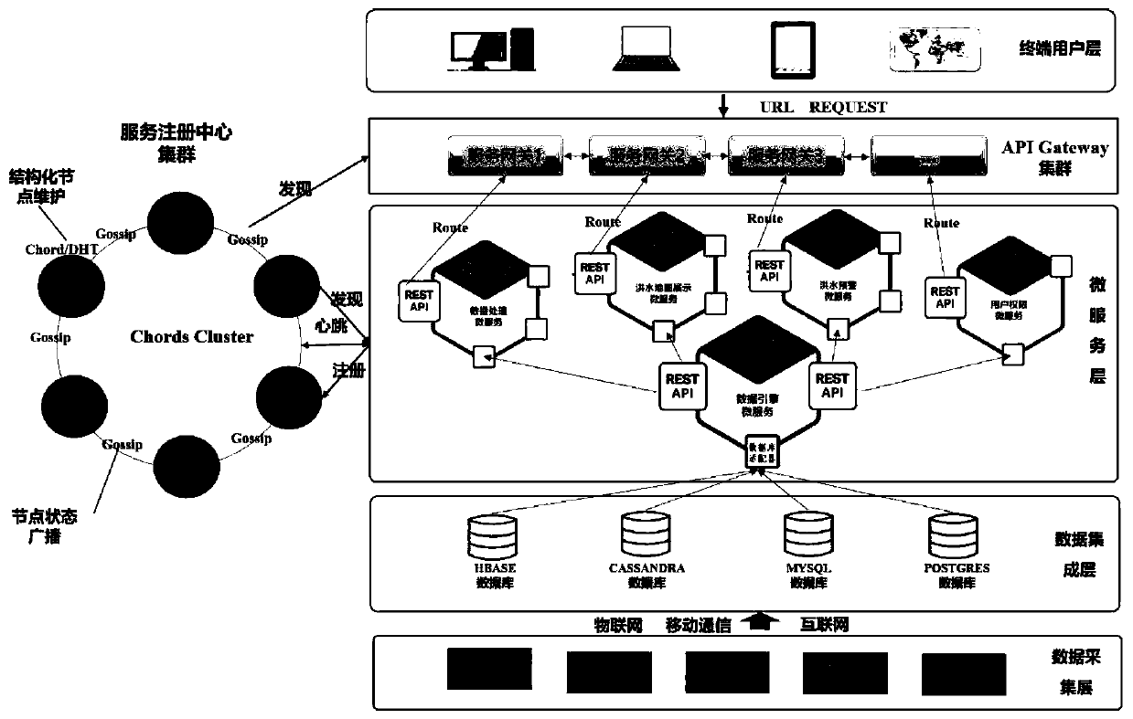
[0040] A decentralized micro-service regional flood warning information system, including six parts: data collection layer, data integration layer, micro-service layer, service registration center cluster, API Gateway cluster, and end-user layer.
[0041] 1. The data acquisition layer: collect real-time water information data monitored by various sensors through the Internet of Things, the Internet and mobile communication technologies, and store them persistently in the database of the data integration layer.
[0042] 2. The data integration layer: a hybrid database including a relational database and a non-relational database, through which the hybrid database defines and persistently stores four types of data support establishment: user management data, real-time water information data, model information data, and spatial data Flood warning model and flood submergence map display function; the user management data includes user name, password, authorization authority data (a...
Embodiment 2
[0054] The integration method of the decentralized micro-service regional flood warning information system based on embodiment 1 includes the following working steps:
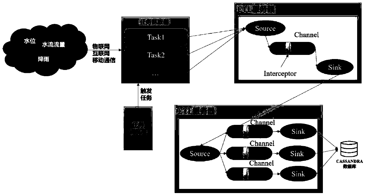
[0055] 1. Acquisition and processing of real-time water information data: realized by a data acquisition and processing device, the data acquisition and processing device includes three parts: a task grabber, a task scheduler and an ETL server; the task grabber captures real-time The water information data is uploaded to the data processing microservice in the microservice layer; the data processing microservice uses the distributed Pipe technology ETL server to transmit massive real-time data, and implements different Interceptors in the Pipe for data cleaning and assimilation processing; finally The data is stored in the non-relational database of the data integration layer, which can be used for flood warning microservices and flood map display microservices to support user interactive real-time query; the ta...
Embodiment 3
[0062] The method can be embodied in many different forms in combination with specific regions, and is applied in the watershed above Wangjiaba of the Huaihe River or the watershed above the Danjiang Estuary of the Yangtze River.
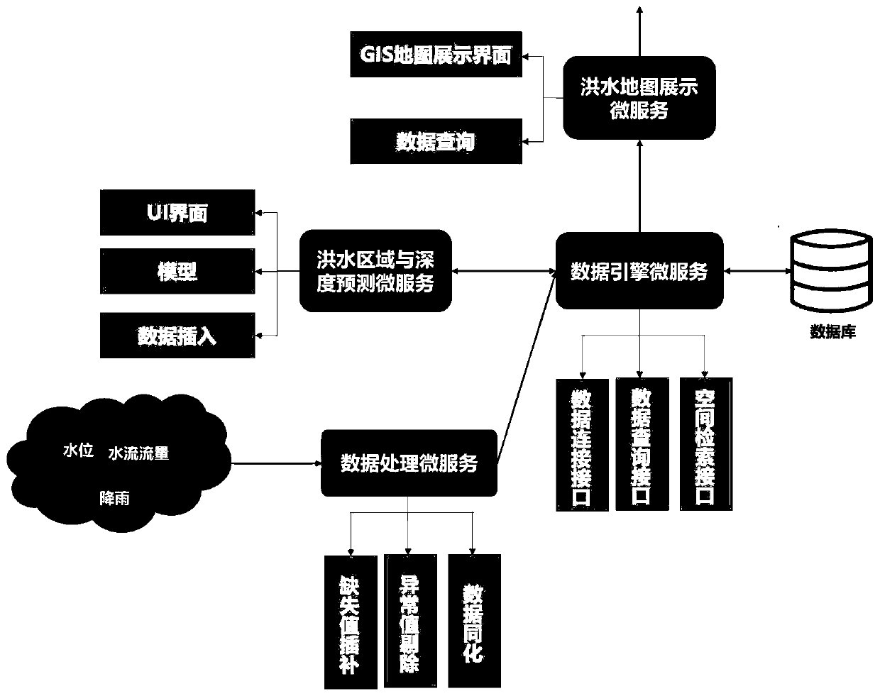
[0063] Examples such as figure 1 , figure 2 , where the data acquisition layer includes real-time water information (water level, flow, rainfall) data stored by three CASSANDRA database nodes, three HBASE database nodes store watershed DEM terrain data, and one PostgresSQL database stores administrative boundaries, meteorological stations, and hydrological stations Space vector data and 1 Mysql database store user authority data, system configuration data and model parameter data; the data integration layer includes 2 server nodes to deploy data collectors; the microservice layer includes 6 server nodes, each of which is a flood warning microservice Nodes, 1 flood display micro-service node, 1 data engine micro-service node, 1 user authority micro...
PUM
 Abstract
Description
Claims
Application Information
 - R&D
- Intellectual Property
- Life Sciences
- Materials
- Tech Scout
- Unparalleled Data Quality
- Higher Quality Content
- 60% Fewer Hallucinations
Browse by: Latest US Patents, China's latest patents, Technical Efficacy Thesaurus, Application Domain, Technology Topic, Popular Technical Reports.
© 2025 PatSnap. All rights reserved.Legal|Privacy policy|Modern Slavery Act Transparency Statement|Sitemap|About US| Contact US: help@patsnap.com


