Reconstruction method of wetland landscape pattern in period without remote sensing data

A technology of remote sensing data and wetland landscape, applied in data processing applications, electrical digital data processing, special data processing applications, etc., can solve the problem of difficult access to historical wetland landscape spatial distribution data, and achieve the effect of improving accuracy

Active Publication Date: 2019-10-15
NORTHEAST INST OF GEOGRAPHY & AGRIECOLOGY C A S
View PDF2 Cites 3 Cited by
  • Summary
  • Abstract
  • Description
  • Claims
  • Application Information

AI Technical Summary

Problems solved by technology

[0004] The purpose of the present invention is to solve the technical problem that the historical wetland landscape spatial distribution data is difficult to obtain, and to provide a reconstruction method of the wetland landscape pattern in the period without remote sensing data

Method used


Image

  • Reconstruction method of wetland landscape pattern in period without remote sensing data
  • Reconstruction method of wetland landscape pattern in period without remote sensing data

Examples


specific Embodiment

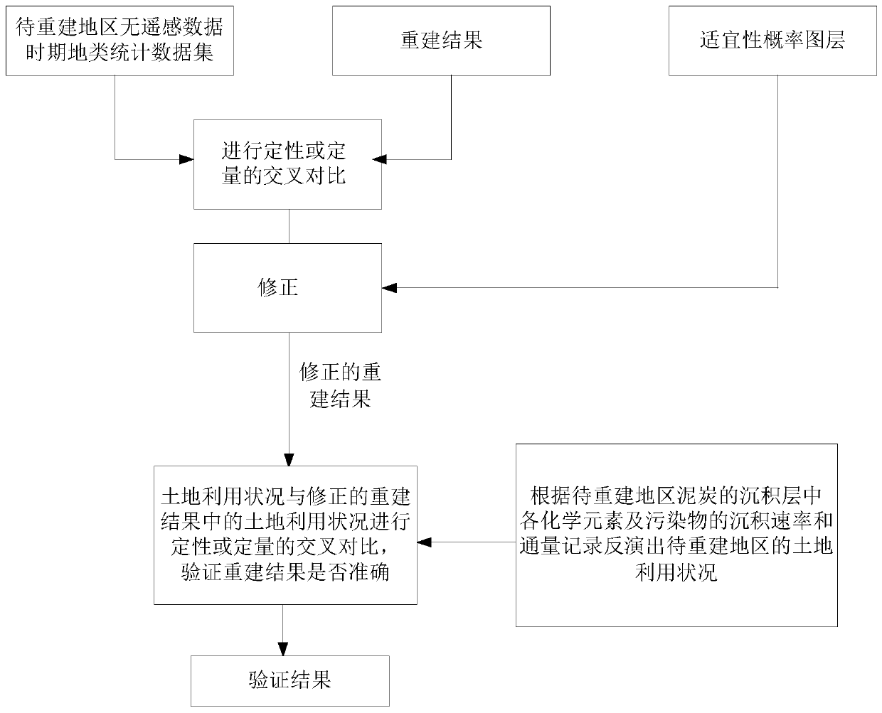
[0040] S1: Using 1960s Northeast statistical reports and Russian survey materials, through uniform conversion of different measurement units into clear acres, estimation of concealment ratio, estimation of cultivated land by population, mutual correction and comparison with existing land data And through the parallel analysis of historical documents, statistical analysis and other methods to establish the relationship model of each source data to correct and process the data, thus forming the 1960s Heilongjiang River Basin topographical statistical data set.

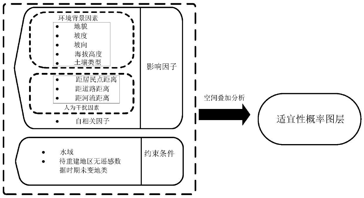
[0041] S2: Analyze the current pattern of land use and land cover change in the Heilongjiang River Basin, as well as factors such as topography, rivers, climate, and population, and analyze the impact of each factor on the change and distribution of land types, and obtain a data set of unchanged land types in the Heilongjiang River Basin in the 1960s.

[0042] S3: By superimposing the Heilongjiang River Basin land type di...


PUM


Abstract

The invention relates to a reconstruction method of a wetland landscape pattern in a period without remote sensing data, and belongs to the field of wetland protection and recovery, solving the problem that historical wetland landscape spatial distribution data is difficult to obtain. The reconstruction method comprises the following steps: obtaining a land type statistical data set in the periodwithout remote sensing data in a to-be-reconstructed region; obtaining a suitability probability graph layer of a to-be-reconstructed region; reconstructing a wetland landscape pattern in a period without remote sensing data by utilizing topographic map data; comparing the reconstruction result with the record of the corresponding period in the acquired land type statistical data set, verifying the reconstruction result by using the suitability probability graph layer, and correcting the reconstruction result; determining peat in a to-be-reconstructed region as a research object; and obtainingthe deposition rate and flux record of each chemical element and pollutant in the deposition layer of the peat on a hundred-year scale, inverting the land utilization condition of the to-be-reconstructed region according to the record, comparing the land utilization condition with the corrected land utilization condition in the reconstruction result, and verifying whether the reconstruction result is accurate or not.

Description

technical field [0001] The invention belongs to the field of wetland protection and restoration, and specifically relates to a method for reconstructing a wetland landscape pattern in a period without remote sensing data. Background technique [0002] Wetlands have important ecological service functions such as water conservation and hydrological regulation, biodiversity and habitat maintenance, carbon storage and climate regulation, and play an irreplaceable role in maintaining regional ecological security. Wetlands are very sensitive to climate change and human activities, especially in recent years, under the disturbance of climate change and human activities, the structure and function of wetland ecosystems have undergone tremendous changes. Further supplementing and improving the spatial distribution data of wetland landscape is an important basis for carrying out research on the driving mechanism of wetland landscape pattern evolution in the past century and the predic...

Claims


Application Information

Patent Timeline
IPC IPC(8): G06F17/50G06Q50/26
CPCG06Q50/26G06F2111/04G06F30/20Y02A90/10
Inventor 杜嘉周昊昊刘欣婷项小云赵博宇
Owner NORTHEAST INST OF GEOGRAPHY & AGRIECOLOGY C A S
Why Eureka
Try Eureka