Built-up area boundary identification method and device based on urban building space data

A technology for building space and boundary recognition, applied in character and pattern recognition, instruments, computer parts, etc., can solve the problems of random boundary recognition, time-consuming recognition methods, and high image quality requirements, and meet various index data. and vector analysis requirements, ensuring scientific and rationality, and ensuring the effect of operability

Active Publication Date: 2019-08-16
SOUTHEAST UNIV +2
View PDF2 Cites 11 Cited by
  • Summary
  • Abstract
  • Description
  • Claims
  • Application Information

AI Technical Summary

Problems solved by technology

[0004] Purpose of the invention: The technical problem to be solved by the present invention is to provide a built-up area boundary recognition method and equipment based on urban building space data, which solves the problem of time-consuming, large manpower input, boundary recognition relying on human brain judgment and large randomness in existing reco...

Method used


Image

  • Built-up area boundary identification method and device based on urban building space data
  • Built-up area boundary identification method and device based on urban building space data
  • Built-up area boundary identification method and device based on urban building space data

Examples


Embodiment Construction

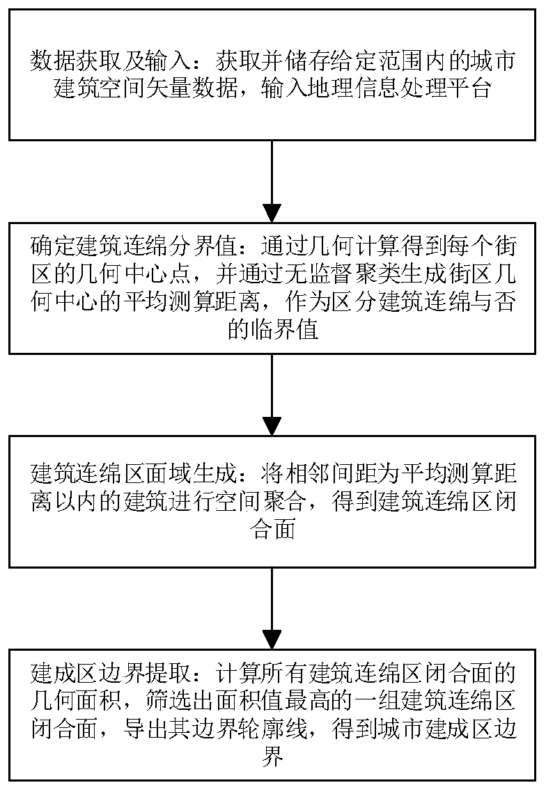
[0039] Such as figure 1 As shown, the embodiment of the present invention discloses a built-up area boundary recognition method based on urban building space data, including the following steps

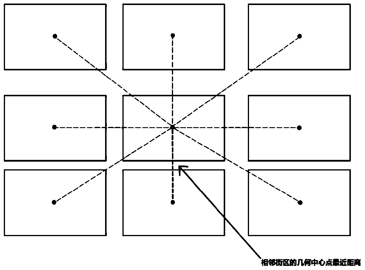
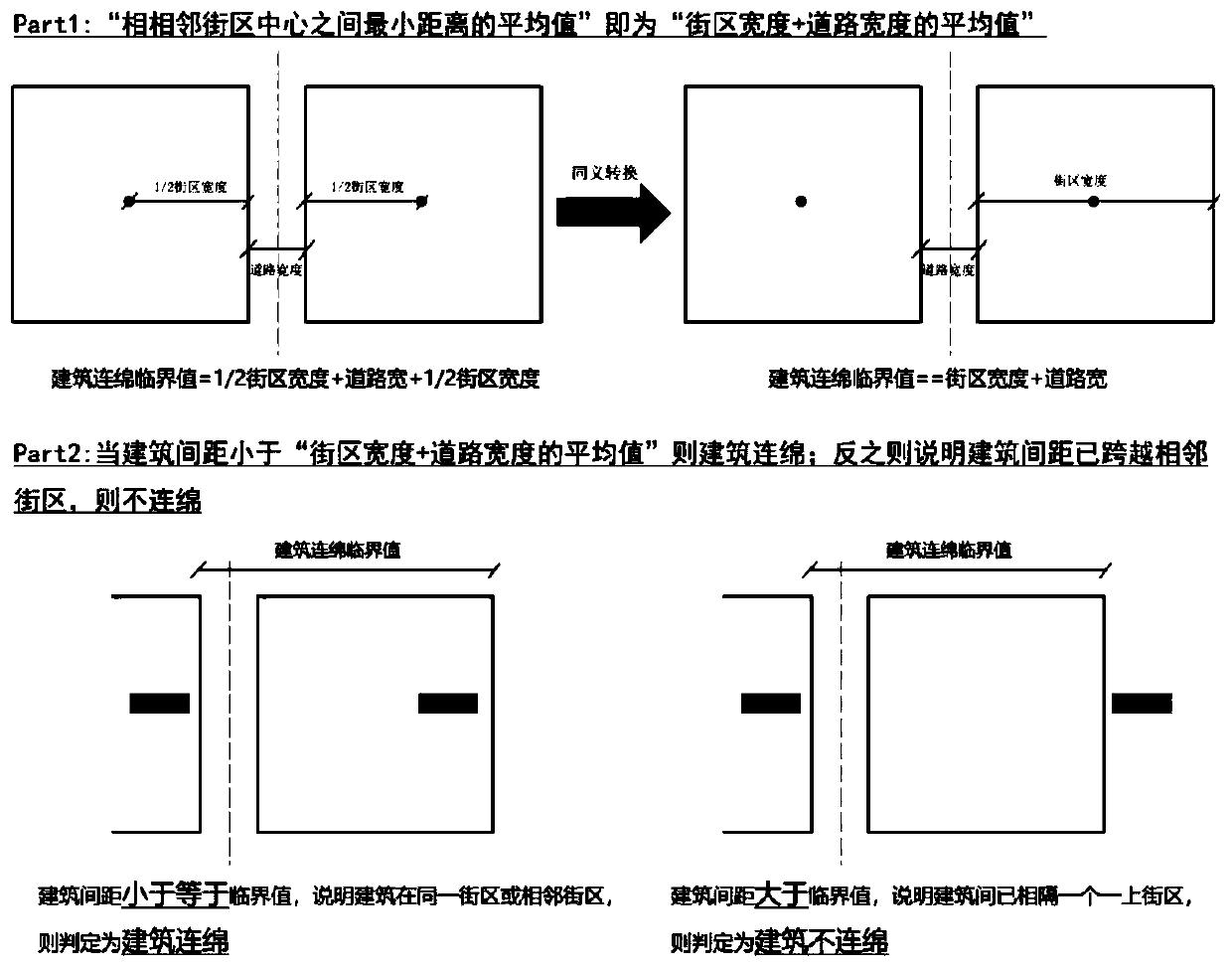
[0040] Step 1): Data acquisition and input: Acquire and store urban building space vector data within a given range, and input it to the geographic information processing platform; wherein, the given range should not be smaller than the city center area, and the city center area is the corresponding The range of the central urban area defined in the latest version of the city's overall urban planning; the building space vector data includes polygonal block surfaces and polygonal building surfaces.

[0041] The space vector data can be obtained through planning bureaus and other relevant government departments. Among them, the building space vector data includes a polygonal block surface (which can also be generated by synthesizing a surface surrounded by road red lines), and the bloc...


PUM


Abstract

The invention discloses a built-up area boundary identification method and device based on urban building space data. The method comprises the following steps: 1) inputting urban building space vectordata into a geographic information processing platform; 2) determining a critical value for distinguishing whether the building is continuous or not; 3) generating a building continuous area surfacearea; and 4) screening a group of building continuous area surface areas with the highest building area values, and exporting boundary contour lines of the building continuous area surface areas. Thedefects that an existing recognition method is long in time consumption, large in manpower input, large in boundary recognition dependence on human brain judgment randomness, high in image quality requirement and the like are overcome. High-precision identification of the boundary of the urban built-up area is realized through data clustering analysis and spatial aggregation, and various index data and vector analysis requirements required by the urban development and construction current situation assessment and planning field are efficiently and accurately met.

Description

technical field [0001] The invention relates to a method and equipment for identifying the boundaries of urban built-up areas, in particular to a method and equipment for identifying the boundaries of built-up areas based on urban building space data. Background technique [0002] The boundary of the urban built-up area refers to the boundary line of the urban built-up area composed of relatively concentrated buildings, urban public facilities and urban roads within the urban administrative area. usage. With the rapid development of social economy, the speed of urbanization in China is astonishing. The delineation of urban construction land boundaries plays an important role in reflecting the scale and speed of urban development and judging land use benefits and growth trends. On the one hand, changes in the scope and boundaries of built-up areas reflect the direction and scale of urban development, and their accurate and reasonable delineation plays a key role in the stud...

Claims


Application Information

Patent Timeline
IPC IPC(8): G06K9/00G06K9/62
CPCG06V20/176G06F18/23213Y02A30/60
Inventor 杨俊宴邵典方创琳甄峰孙瑞琪陆小波史北祥冯建喜曹俊
Owner SOUTHEAST UNIV
Why Eureka
Try Eureka