
Network RTK (Real-Time Kinematic) positioning method for obtaining coordinate and normal height of reference-ellipsoid-centric coordinate system in real time

A ginseng coordinate system and positioning method technology, applied in the field of surveying and mapping geographic information, can solve the problems of high quality requirements of mobile stations, baseline solution errors, and no discussion of "another coordinate system rule"

Inactive Publication Date: 2013-08-07
WUHAN UNIV
View PDF4 Cites 10 Cited by
  • Summary
  • Abstract
  • Description
  • Claims
  • Application Information

AI Technical Summary

Problems solved by technology

[0008] In order for the mobile station to obtain the coordinates of the ginseng coordinate system, there are three conventional methods: 1) The mobile station submits the measured WGS84 coordinates in written form to the surveying and mapping results storage unit approved by the State Bureau of Surveying and Mapping. Coordinate conversion after the event, and the result will be sent back to the mobile station. This mode has good confidentiality, and the accuracy and reliability of the results are guaranteed, but the procedure is cumbersome, the work efficiency is low, and it is not real-time, which cannot meet the needs of real-time stakeout ginseng coordinate system coordinates
2) The surveying and mapping results storage unit approved by the State Bureau of Surveying and Mapping establishes a coordinate conversion network service system [2] [3], authorized mobile stations can submit the measured WGS84 coordinates online through the network, and the service system completes the coordinate conversion online and sends the results through the network Feedback to the mobile station. The advantage of this mode is that the mobile station is easy to use and the results are standardized, but it can only be carried out after the measurement is completed, and it cannot meet the needs of real-time stakeout ginseng coordinate system coordinates
3) The mobile station obtains parameters by itself through the joint measurement of known points. There must be known point distribution near the survey area, the field workload is heavy, the data processing is relatively complicated, the quality requirements of the mobile station are high, the operation efficiency is low, and the accuracy of the results is low. and reliability are not guaranteed
[0009] In order to enable the RTK rover to obtain the coordinates of the ginseng coordinate system in real time, some scholars have proposed several solutions, which can be roughly divided into five types: 1) Store the conversion parameters in the form of software modules in the measuring device of the rover (PDA ) in [4], the biggest disadvantage of this method is that it cannot ensure that the parameters are not leaked, and different brands or models of equipment need to develop modules separately, which not only involves massive conversion parameters between different coordinate systems in various places, but also involves different production It is very difficult for manufacturers to develop, actually use and promote
2) Send the seven confidential parameters to the rover via a differential message [5], and the equipment of the rover obtains the coordinate conversion parameters from the differential message. At present, only a few differential messages (such as RTCM3.1) and the latest equipment of a very small number of brands support this This mode, because the encoding method of the differential message is open, anyone can obtain it through decoding, so its confidentiality is almost zero, especially not applicable in China
3) Convert the coordinates of the reference station in the differential message to the coordinates of the ginseng coordinate system and then send it to the rover[6], because the difference between the ECEF coordinates and the coordinates of the ginseng coordinate system at the same point may reach about 100m or even greater, The coordinates of the reference station are the coordinates of the starting point of the rover for baseline calculation. Usually, the coordinates of the starting point with an error of more than 30m will cause a large baseline calculation error, and the longer the baseline, the greater the impact; at the same time, this mode ignores the point with the same name The difference between the baseline in the WGS84 coordinate system and the ginseng coordinate system is that the reference station (virtual or actual) is far away from the rover (for example, in the single reference station mode, the rover and the reference station can tens of kilometers away), or when the values ​​of the rotation angle and zoom ratio in the seven parameters are large, and when these two factors exist at the same time, ignoring this difference may cause a huge error
The invention application did not provide theory and formula derivation, neither the pseudo-datum nor the cube gave a clear determination method, nor did it explain how to ensure that the pseudo-datum would remain consistent with the specific datum after projection; in fact, there are usually many kinds of datums (such as Beijing 54 , Xi’an 80, etc.), the rover may need different datums in different projects, and the algorithm can only target a certain kind of datum, which will make the algorithm unable to cope with the situation where there are multiple datums in the same area; according to VRS difference It is also imprecise to use the reference station coordinates in the message to determine the approximate position of the mobile station
5) Zhang Li and others discussed the security mode of adding an intermediate server and "another coordinate system" [8], but did not give specific calculation formulas for the conversion parameters from "another coordinate system" to the local coordinate system, and stayed at The discussion level of the model, and did not discuss the rules that "another coordinate system" should follow, ignoring the influence of "another coordinate system" on the positioning results of the rover
Schemes 3) to 5) have one thing in common besides their respective shortcomings: none of them proposed a solution for real-time measurement of normal height by RTK

Method used


Image

  • Network RTK (Real-Time Kinematic) positioning method for obtaining coordinate and normal height of reference-ellipsoid-centric coordinate system in real time
  • Network RTK (Real-Time Kinematic) positioning method for obtaining coordinate and normal height of reference-ellipsoid-centric coordinate system in real time
  • Network RTK (Real-Time Kinematic) positioning method for obtaining coordinate and normal height of reference-ellipsoid-centric coordinate system in real time

Examples


Embodiment Construction

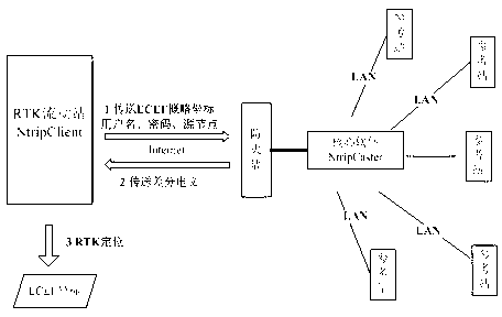
[0049] The ECEF described in the present invention includes WGS84, ITRS, PE-90, CGCS2000, etc., and the ginseng coordinate system includes the 1954 Beijing coordinate system (abbreviated as "Beijing 54"), the 1980 Xi'an coordinate system (abbreviated as "Xi'an 80"), the new 1954 Beijing Coordinate system, etc. Elevation benchmarks include Baltic Sea elevation, Wu Song elevation system, Guangzhou elevation, Pearl River elevation, Yellow Sea elevation system in 1956, National elevation datum in 1985, etc. The realization methods are the same. The technical solution of the present invention will be described in detail below in conjunction with the drawings and embodiments.

[0050] In the example, a certain province established a CORS system with 100 reference stations. NtripCaster (CORS service software) uses the GPSNet software developed by Trimble Company. The coordinates directly measured by the rover using the CORS system belong to WGS84. The conversion parameters from WGS84...


PUM


Abstract

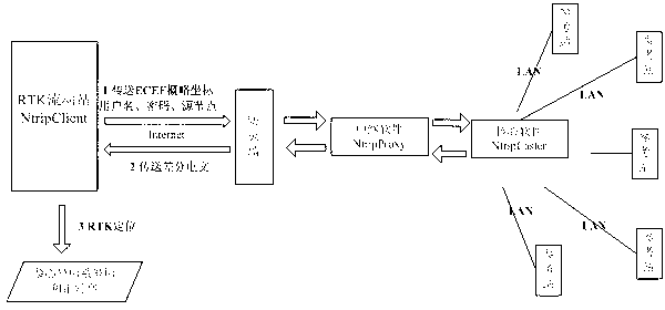
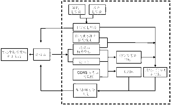
The invention relates to a network RTK (Real-Time Kinematic) positioning method for obtaining coordinates and normal height of a reference-ellipsoid-centric coordinate system in real time. Source nodes are expanded and are used for transmitting the demand of a moving station in a more detailed manner, the NTRIP (Networked Transport of RTCM via Internet Protocol) is not required to be modified, judgment and an algorithm are only required to be correspondingly added into NtripCaster software or an NtripProxy relay module is only required to be added between NtripCaster and the moving station, and the method is easy to realize; if the coordinates of the reference-ellipsoid-centric coordinate system are required to be obtained in real time, the corresponding source node is only required to be selected during logging-in to a server, non-secret-involved seven parameters are filled in a handbook and other operation modes are unchanged; if the moving station needs to obtain the normal height, the corresponding source node is only required to be selected during logging-in to the server and other operation modes are unchanged; and on the premise that the state privacy policies are complied, the goals of measuring and staking out the coordinates and the normal height of the reference-ellipsoid-centric coordinate system in real time are realized.

Description

technical field [0001] The invention relates to the technical field of surveying and mapping geographic information, in particular to a network RTK positioning method for real-time acquisition of ginseng coordinate system coordinates and normal heights. Background technique [0002] GNSS (Global Navigation Satellite System) technology is the most widely used positioning method in the field of surveying and mapping. Using a single GNSS device for standard single-point positioning, the accuracy of the coordinates obtained under ECEF (Earth-centered Earth-fixed coordinate system, such as WGS84) is generally 10-20 meters (no SA). By constructing RTK (carrier phase real-time dynamic differential positioning) system, the positioning accuracy within 30km can reach centimeter level. [0003] RTK is mainly composed of a reference station and a rover. The reference station sends a differential message to the rover through a data link, which contains the ECEF coordinates of the refere...

Claims


Application Information

Patent Timeline
IPC IPC(8): G01S19/12
Inventor 郭际明章迪罗年学巢佰崇
Owner WUHAN UNIV
Learn More