
Urban forest monitoring method based on cooperation of high-resolution remote sensing data and ground survey data

A technology of remote sensing data and data collaboration, applied in the field of urban forest monitoring, can solve problems such as low efficiency, low forest cover extraction accuracy, and re-checking, etc., to achieve the effect of improving monitoring accuracy and supported by credible technical means

Pending Publication Date: 2022-03-11
中国自然资源航空物探遥感中心
View PDF0 Cites 3 Cited by
  • Summary
  • Abstract
  • Description
  • Claims
  • Application Information

AI Technical Summary

Problems solved by technology

[0006] The purpose of the present invention is to overcome the problems of low extraction accuracy of forest cover with high fragmentation degree in the existing method, and need to re-draw samples for each extraction, low efficiency and other deficiencies, and provide a high-resolution remote sensing data and ground survey The urban forest monitoring method based on data collaboration realizes the rapid extraction and efficient monitoring of urban forest distribution based on the sample library

Method used


Image

  • Urban forest monitoring method based on cooperation of high-resolution remote sensing data and ground survey data
  • Urban forest monitoring method based on cooperation of high-resolution remote sensing data and ground survey data
  • Urban forest monitoring method based on cooperation of high-resolution remote sensing data and ground survey data

Examples


Embodiment Construction

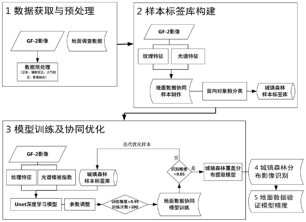
[0060] The present invention will be further described below in conjunction with the accompanying drawings, such as figure 1 As shown, the method steps of the present invention are as follows:

[0061] Step 1: Data acquisition and preprocessing

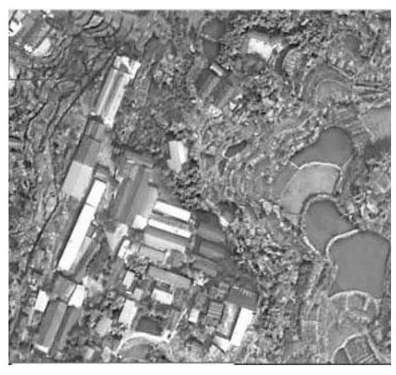
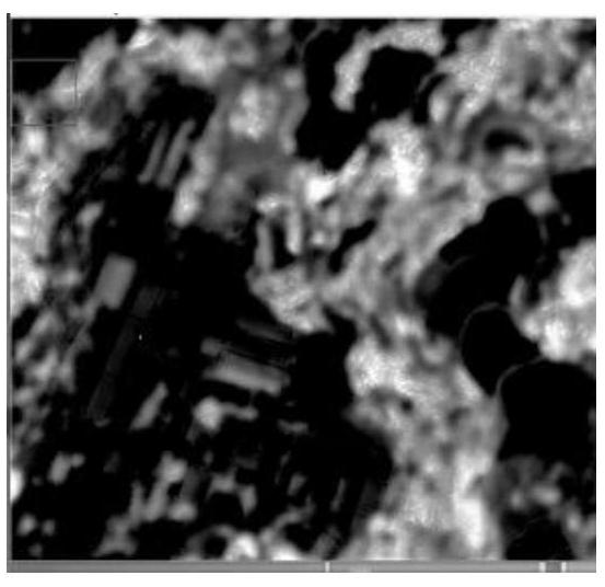
[0062] Beibei District of Chongqing City is used as a demonstration area for the implementation of the present invention. First, the original image of Gaofen-2 in this area was acquired in February 2017. Using ENVI software (version 5.3 used in the present invention) to perform orthophoto correction, radiometric correction, atmospheric correction, multi-spectral and panchromatic channel image fusion and other operations on the remote sensing data successively, and crop the fused image by region to obtain the surface of the demonstration area. reflectivity image;

[0063] Conduct ground surveys on the distribution of urban forests in different scenarios such as streets, parks, and forests outside built-up areas in Beibei District, a...


PUM


Abstract

The invention discloses a high-resolution remote sensing data and ground data collaborative town forest monitoring method. The method comprises the following steps: step 1, data acquisition and preprocessing; step 2, constructing an urban forest sample label library; step 3, training and collaborative optimization of an urban forest distribution recognition model based on deep learning; step 4, identifying town forest images; and 5, verifying the ground precision of the urban forest identification result. The method has the advantages that (1) the recognition rate of the method is higher than that of a traditional method for the urban forest area with the high crushing degree; and (2) aiming at a domestic Gaofen-2 satellite image, a cooperative monitoring method of ground observation data in the whole process of sample making, urban forest coverage distribution identification and precision inspection is provided, and the monitoring precision of the urban forest is effectively improved through cooperative use of the ground observation data. And (3) the method can provide efficient and credible technical means support for related industry departments in the field of natural resources to carry out investigation and monitoring work of urban forest resources.

Description

technical field [0001] The invention relates to a method for monitoring urban forests in which high-resolution remote sensing data and ground data are coordinated, in particular to a method for monitoring urban forests based on deep learning for co-monitoring high-resolution remote sensing data and ground survey data. Remote sensing identification technology field. Background technique [0002] Urban forests generally refer to forests located in urban planning areas. The main goal of urban forests is to protect and build local ecosystems with regionality, diversity and self-succession to improve the urban ecosystems. With ecological culture or technology as the theme, it can provide sightseeing and recreation in harmony with the natural ecological process. , public places for practice and other activities. Urban forests directly provide ecological services for cities and towns, and are an important part of the urban complex ecosystem. They play an irreplaceable role in mai...

Claims


Application Information

Patent Timeline
IPC IPC(8): G01N21/84G06N3/04G06N3/08
CPCG01N21/84G06N3/04G06N3/08
Inventor 刘镕源白娟杨会贇王薇闫柏琨甘甫平
Owner 中国自然资源航空物探遥感中心
Learn More