Multi-person collaborative operation method for geographic information data production and updating

A technology of geographic information data and data, applied in geographic information database, database update, structured data retrieval and other directions, can solve the problems of low operation efficiency, increase the work of data map borders, hidden quality problems, etc., and increase the operation efficiency. The effect of personnel input, ensuring smooth completion on schedule, and good application effect

Pending Publication Date: 2021-10-29
THE THIRD GEOINFORMATION MAPPING INST OF MINISTRY OF NATURAL RESOURCES
View PDF4 Cites 1 Cited by
  • Summary
  • Abstract
  • Description
  • Claims
  • Application Information

AI Technical Summary

Problems solved by technology

[0002] The existing traditional basic surveying and mapping update technology needs to physically cut the cross-frame elements, which increases the tedious work of joining the data frame after the production update, and the efficiency is low; the online collaborative update technology of ArcGIS is limited by the data volume, Constrained by many conditions such as the number of concurrent users and version editing time, the management of massive data, the increase of concurrent users (more than 3 people), the increase of version editing time, etc., will lead to slow response speed, refresh waiting, or even freeze , which seriously affects the work efficiency
[0003] The traditional framing operation technical scheme needs to physically cut the data according to the standard framing. A large number of complete geographic element objects are divided into multiple parts and distributed to different operators for processing. Operators can only pay attention to parts during the production process. Information, and after the framing data production update is completed, complex border work will be carried out, involving geometric accuracy, graphic articulation, attribute correction, etc., resulting in low operation efficiency and hidden quality risks; the space based on the ArcSDE version control strategy Data online collaborative update technology can enable multiple people to edit the same data at the same time, without the need for slicing and border work, which improves the efficiency of data production to a certain extent, but this technical solution is highly dependent on the performance of the central server and the local area network environment. Version registration, role and user permission configuration, in the face of massive data, multi-user concurrency, etc., may easily cause slow response of the server, or even freeze phenomenon. Every time one person’s job is added or a certain amount of data is added, the bottleneck phenomenon is very obvious and cannot be satisfied. Large-scale operation requirements in actual production

Method used


Image

  • Multi-person collaborative operation method for geographic information data production and updating

Examples


Embodiment Construction

[0023] The present invention will be further described below in conjunction with accompanying drawing:

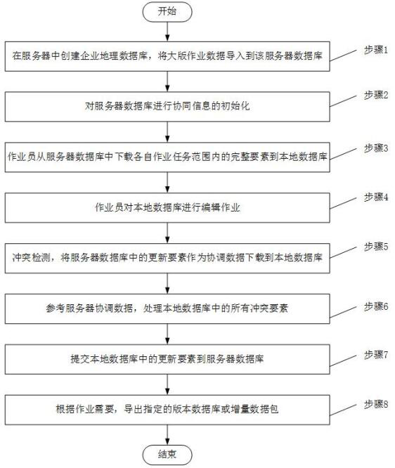
[0024] This patent aims to provide an offline collaborative operation method for updating basic geographic data to solve the cumbersome procedures such as framing and splicing in the traditional framing operation technology and the management of massive data and multi-users in the online collaborative operation technology. The concurrency bottleneck problem meets the needs of multi-person collaborative operations for updating massive geographic information data.

[0025] In order to solve the above problems, this patent provides a set of offline collaborative operation technical solutions for massive geographic information updates. This solution stores large-scale data in the server database and initializes them. Through subtask partition files, operators download their respective jobs. Partition data (elements are not interrupted) to the local database, perform offline edi...


PUM


Abstract

The invention discloses a multi-person collaborative operation method for geographic information data production updating, and provides an off-line collaborative operation method which adopts a basic thought that mass data is subjected to centralized management in a server and multi-person off-line collaborative operation editing in a client. Through the technical methods of version management, updating process data redundancy storage, conflict detection, conflict processing and the like, multi-person off-line collaborative operation oriented to massive geographic information data is realized, so the editing efficiency is irrelevant to the server data volume and the number of collaborative operation personnel, and the operation efficiency is improved. Through a version management and updating process data redundancy storage method, the editing process backtracking of specified elements can be supported, and export of incremental updating data between any version database and any two specified versions is realized. The multi-person collaborative operation requirement for mass data can be met, the investment of operators can be flexibly increased at low cost according to the project requirement, and it is guaranteed that the project is smoothly completed on schedule.

Description

technical field [0001] The invention relates to the geographic information industry, and is mainly aimed at the technical field of geographic information data production and updating in a large area, with a large amount of data, requiring multiple people to work at the same time, and specifically relates to a multi-person collaborative operation method for geographic information data production and updating. Background technique [0002] The existing traditional basic surveying and mapping update technology needs to physically cut the cross-frame elements, which increases the tedious work of joining the data frame after the production update, and the efficiency is low; the online collaborative update technology of ArcGIS is limited by the data volume, Constrained by many conditions such as the number of concurrent users and version editing time, the management of massive data, the increase of concurrent users (more than 3 people), the increase of version editing time, etc., w...

Claims


Application Information

Patent Timeline
Patent Type & Authority Applications(China)
IPC IPC(8): G06F16/23G06F16/27G06F16/29
CPCG06F16/2372G06F16/275G06F16/29
Inventor 李忠任东宇周启文学虎罗浩卢文渊
Owner THE THIRD GEOINFORMATION MAPPING INST OF MINISTRY OF NATURAL RESOURCES
Why Eureka
Try Eureka