Spatio-temporal big data grid coding efficient visualization method and system
A space-time data and grid coding technology, which is applied in database indexing, structured data retrieval, geographic information database, etc., can solve the problems of low efficiency of space-time big data visualization, large visualization time consumption, and large data request volume, etc., to improve Data request and data query efficiency, improve query efficiency and visual expression, and reduce response time
- Summary
- Abstract
- Description
- Claims
- Application Information
AI Technical Summary
Problems solved by technology
Method used
Image

Examples
Embodiment 1
[0053] An efficient visualization method for spatial-temporal big data grid coding, the method comprising the following steps:
[0054] A. Establish a spatio-temporal big data visualization model, construct a grid-coded index data structure on the spatio-temporal big data visualization model, and obtain a coded index data set, and store the coded index data set in the spatio-temporal database. The coded index data set includes codes , The corresponding relationship between index and data; select or set the visual domain on the spatio-temporal big data visualization model, and obtain the visual domain coding index data set corresponding to the visual domain;
[0055] B. Set the visualization main thread and data request sub-thread for the visual domain of the spatio-temporal big data visualization model; collect spatio-temporal data and perform grid coding dimension reduction projection processing and transmit it to the data request sub-thread, and the data request sub-thread is...
Embodiment 2
[0075] An efficient visualization method for spatial-temporal big data grid coding, the method comprising the following steps:
[0076] A. Establish a spatio-temporal big data visualization model, construct a grid coded index data structure on the spatio-temporal big data visualization model, the construction method of the grid coded index data structure is as follows: according to the principle of equal longitude and latitude The visualization model is divided into several sub-level grid units according to the quadtree grid;
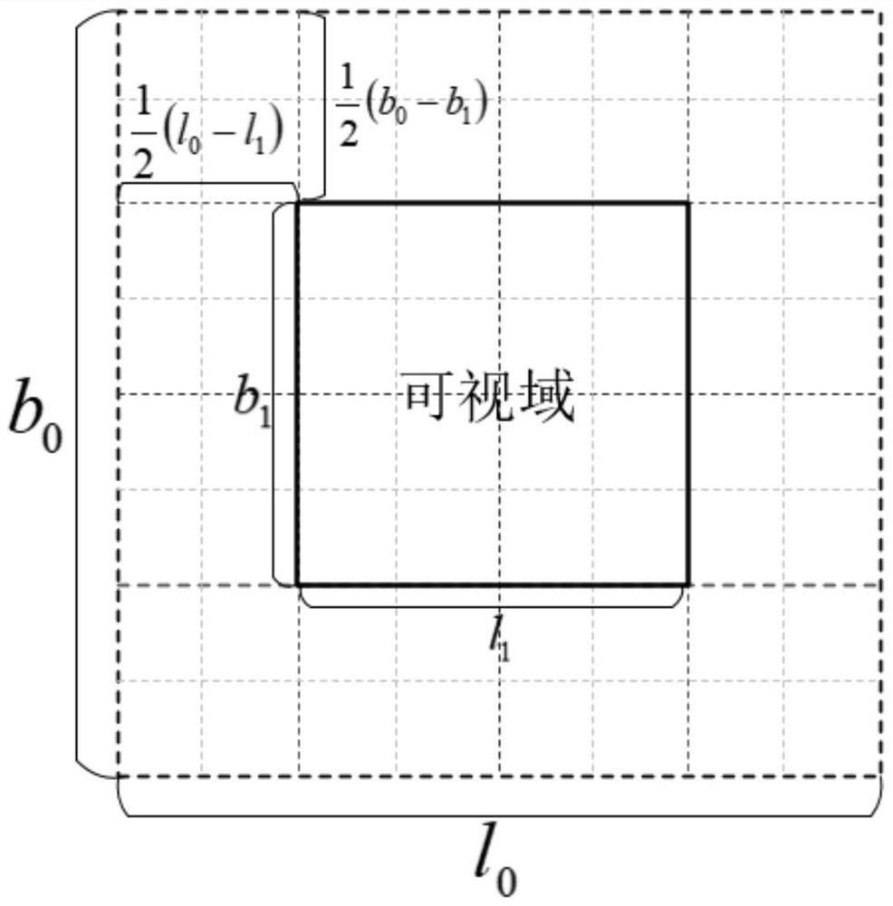
[0077] According to the difference l in gridding 0 , latitude difference b 0 , the difference l in the meshing of the visible domain 1 , latitude difference b 1 , to obtain the sets X and Y of the row and column numbers of the visual field encoding:
[0078] Visibility encoding line number set
[0079] A collection of column numbers for viewport encodings Where x represents the grid coding level;
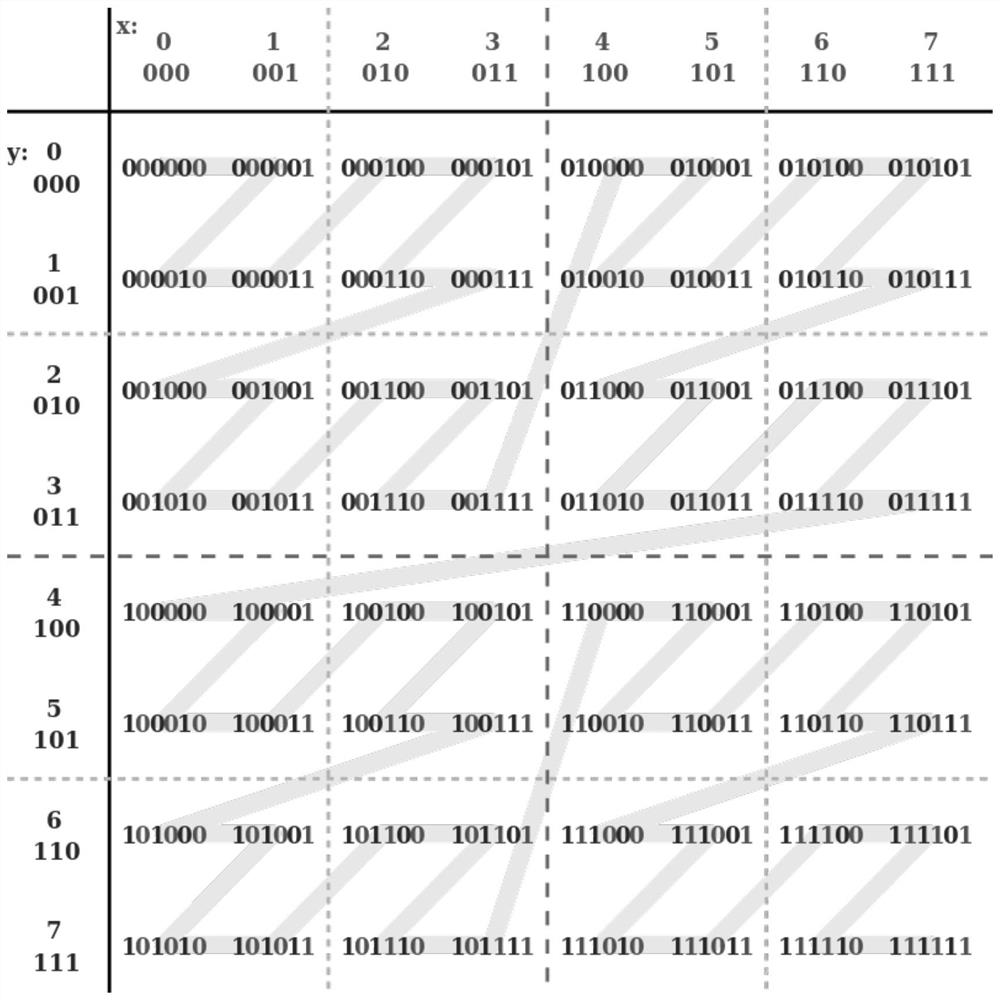
[0080] According to the Morton coding rules, ...
Embodiment 3
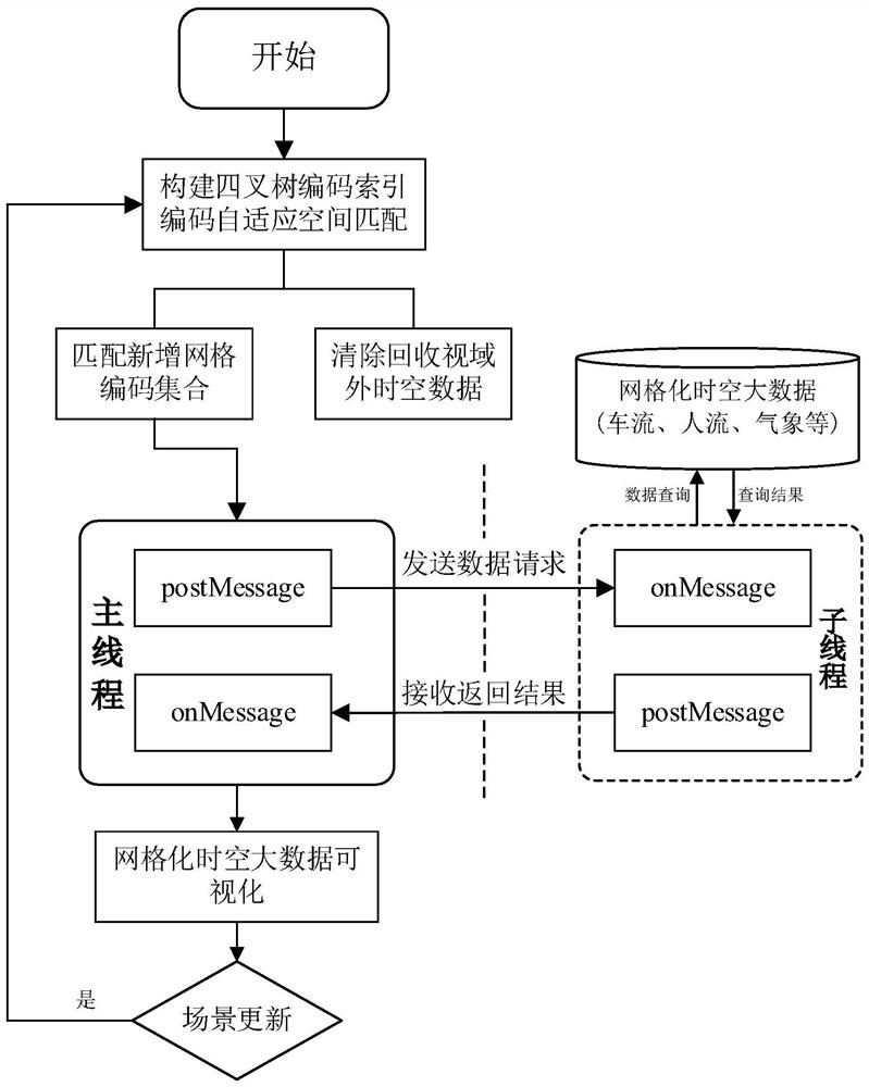
[0085] Such as figure 1 As shown, an efficient visualization method for spatial-temporal big data grid coding, the method includes the following:
[0086] S1. Establish a spatio-temporal big data visualization model, build a quadtree grid coding index in a local area on the spatio-temporal big data visualization model, perform grid coding and dimensionality reduction expression on the spatio-temporal big data, and realize the integration of "coding-index-data", Obtain the geospatial encoding set (also known as the encoding index data set) corresponding to the view domain;
[0087] S2. Propose a method for separating front-end data requests and visualization threads of gridded spatio-temporal big data. Sub-threads (also known as data request sub-threads) perform gridded spatio-temporal data queries based on the geospatial code set of the visual domain, and then communicate through threads Pass the query results to the main thread (also known as the visualization main thread), ...
PUM
 Abstract
Description
Claims
Application Information
 - Generate Ideas
- Intellectual Property
- Life Sciences
- Materials
- Tech Scout
- Unparalleled Data Quality
- Higher Quality Content
- 60% Fewer Hallucinations
Browse by: Latest US Patents, China's latest patents, Technical Efficacy Thesaurus, Application Domain, Technology Topic, Popular Technical Reports.
© 2025 PatSnap. All rights reserved.Legal|Privacy policy|Modern Slavery Act Transparency Statement|Sitemap|About US| Contact US: help@patsnap.com