
A multi-satellite characteristic parameter identification and positioning method based on array dual-frequency mutual backup

A characteristic parameter, identification and positioning technology, applied in the field of navigation and positioning, satellite navigation and positioning, can solve the problems of inaccurate measurement of energy attenuation of observation points and emission points, large influence of multipath attenuation on energy positioning, and large multipath influence. Achieve the effect of solving the problem of high-precision navigation and positioning, avoiding the problem of scattered erection, and simple erection

Active Publication Date: 2021-08-31
NO 54 INST OF CHINA ELECTRONICS SCI & TECH GRP
View PDF8 Cites 0 Cited by
  • Summary
  • Abstract
  • Description
  • Claims
  • Application Information

AI Technical Summary

Problems solved by technology

[0002] The positioning performance of satellite navigation systems in indoor and urban canyon areas is poor. At present, the positioning methods in urban canyon areas and indoor areas include Bluetooth, WIFE, wireless communication base station positioning and inertial positioning to solve the problem that satellite signals cannot penetrate walls due to weak signals. However, these methods all have problems of one kind or another, resulting in poor positioning accuracy. For example, the energy positioning adopted by Bluetooth and WIFE is greatly affected by multipath attenuation, and the energy between the observation point and the transmitting point cannot be accurately measured. Attenuation, resulting in poor positioning accuracy; base station positioning cannot be popularized and applied because the number of base stations in the current city cannot meet the needs of high-precision navigation and positioning, and indoors are greatly affected by multipath; inertial navigation positioning requires other technical means to provide initial absolute coordinates and continuously correct the inertial navigation
Therefore, the current indoor navigation and positioning technology cannot meet the needs of high-precision positioning, and it is necessary to carry out research on new technologies and methods in indoor high-precision navigation and positioning.

Method used


Image

  • A multi-satellite characteristic parameter identification and positioning method based on array dual-frequency mutual backup
  • A multi-satellite characteristic parameter identification and positioning method based on array dual-frequency mutual backup
  • A multi-satellite characteristic parameter identification and positioning method based on array dual-frequency mutual backup

Examples


Embodiment Construction

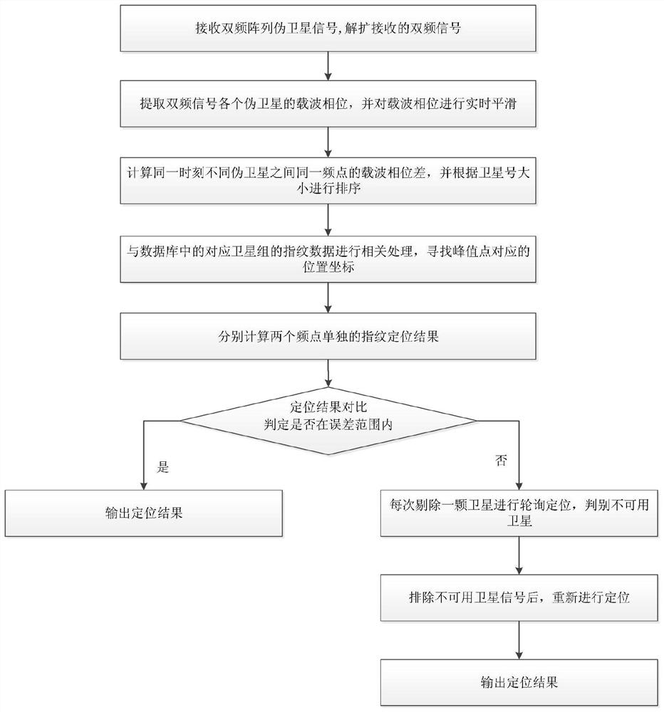
[0019] The present invention will be further described below in conjunction with the accompanying drawings. like figure 1 Shown is a flow chart of a multi-satellite characteristic parameter identification and positioning method based on array dual-frequency mutual backup disclosed in the embodiment of the present invention, which specifically includes the following steps:

[0020] (1) Assume that indoor pseudolite receiving terminal A receives the transmitted signals of K pseudolites as S K , the baseband signal S' is obtained after down-conversion K , the down-conversion process is for the two frequency points to be down-converted respectively, so as to realize the separation of different frequency signals;

[0021] (2) Capture and track the signal of each pseudolite, and extract the carrier phase of each pseudolite at the same time, smooth the real-time carrier phase jump of the pseudolite through the different frequency signals transmitted by the same pseudolite, and smoo...


PUM


Abstract

The present invention proposes a multi-satellite characteristic parameter identification and positioning method based on array dual-frequency mutual backup. Firstly, the pseudolite signal transmitted by the pseudolite array is collected, the signal is despread and the carrier phase of each pseudolite is extracted simultaneously. During the extraction process In this paper, dual-frequency mutual smoothing is used to eliminate the influence of carrier phase cycle slip, and then the cosine parameter of carrier phase difference between different pseudolites is calculated, and the correlation processing is carried out with the corresponding parameters in the database to find the maximum value of the correlation peak, and through the dual-frequency Comparison and satellite integrity testing enable precise navigation and positioning indoors and in urban canyons.

Description

technical field [0001] The invention relates to the field of satellite navigation and positioning, and is particularly suitable for navigation and positioning in indoor and outdoor complex environments, and realizes high-precision navigation and positioning in indoor and outdoor complex environments in the form of dynamic matching of carrier phase difference feature vectors. Background technique [0002] The positioning performance of satellite navigation systems in indoor and urban canyon areas is poor. At present, the positioning methods in urban canyon areas and indoor areas include Bluetooth, WIFE, wireless communication base station positioning and inertial positioning to solve the problem that satellite signals cannot penetrate walls due to weak signals. However, these methods all have problems of one kind or another, resulting in poor positioning accuracy. For example, the energy positioning adopted by Bluetooth and WIFE is greatly affected by multipath attenuation, an...

Claims


Application Information

Patent Timeline
Patent Type & Authority Patents(China)
IPC IPC(8): G01S19/25G01S19/29G01S19/43G01C21/20
CPCG01C21/20G01C21/206G01S19/258G01S19/29G01S19/43
Inventor 蔚保国范广伟甘兴利戎强晁磊
Owner NO 54 INST OF CHINA ELECTRONICS SCI & TECH GRP
Learn More