Method for efficiently converting TIN model into Grid model under DEM architecture

A conversion method and model technology, applied in the field of 3D geographic information system, can solve problems such as unsatisfactory algorithm speed, no practical value, difficult maintenance, etc., shorten the conversion time of different grid spacing, shorten the conversion time of different resolutions, avoid The effect of data structures

Pending Publication Date: 2020-01-10
扆亮海
View PDF0 Cites 3 Cited by
  • Summary
  • Abstract
  • Description
  • Claims
  • Application Information

AI Technical Summary

Problems solved by technology

There are some algorithms in the prior art, but all of them have relatively large defects: First, the establishment of blocks in the algorithm and the use of the matrix method to judge the triangles all need to take a lot of time, the algorithm is complex, and the resources are occupied. High restrictions, can not be extended to practical applications, almost no practical value; second, the search for the nearest vertex and the maintenance and use of the triangular network topology relationship still take a certain amount of time, the algorithm efficiency is still low, the distortion is more serious, and the conversion The front and back errors are large, and frequent maintenance is required, and the error probability is high; the third is to use the rectangular block as the search range when searching for irregular triangles, and then use the point falling in the triangle judgment method to determine which irregular triangle the elevation point falls in. The elevation value of the grid is obtained according to the elevation interpolation, but the theoretical foundation of the method is weak, the reliability is not high in large-scale conversion, the maintenance is difficult, and it is difficult to find the cause after the error, and the algorithm speed is still not ideal.

Method used


Image

  • Method for efficiently converting TIN model into Grid model under DEM architecture
  • Method for efficiently converting TIN model into Grid model under DEM architecture
  • Method for efficiently converting TIN model into Grid model under DEM architecture

Examples


Embodiment Construction

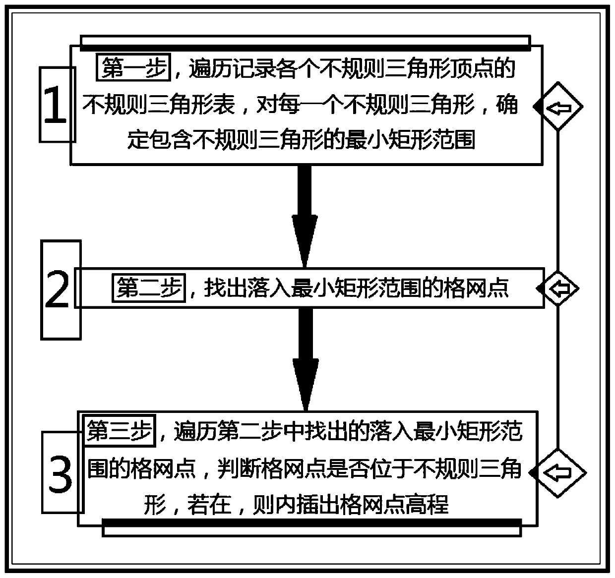
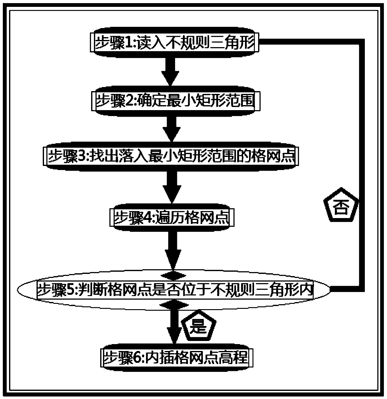
[0049] The technical scheme of the efficient conversion method from TIN to Grid model under the DEM framework provided by the present invention will be further described below in conjunction with the accompanying drawings, so that those skilled in the art can better understand the present invention and implement it.

[0050] see Figure 1 to Figure 3 , the efficient conversion method from TIN under the DEM architecture to the Grid model provided by the present invention, the conversion from TIN to the Grid model under the DEM architecture is a process of interpolation grid point elevation, and the interpolation grid point elevation adopts linear interpolation method to determine the grid point After the irregular triangle to which it belongs, the elevation of the grid point is interpolated in the plane determined by the irregular triangle. In order to improve the speed of elevation interpolation, the core is to quickly search for the irregular triangle where the grid point is l...


PUM


Abstract

The invention provides a method for efficiently converting a TIN model into a Grid model under a DEM architecture. According to the adopted conversion method, conversion is completed only by traversing the irregular triangle table. A complex data structure in the process of constructing the irregular triangulation network is avoided. Therefore, the method disclosed by the invention is relatively simple to implement. Computing speed is also comparatively fast, the range is determined according to the irregular triangle. Therefore, the search range of the corresponding grid points becomes very small. Meanwhile, the coordinate reduction processing in the calculation process is also beneficial to improving the efficiency, and conversion experiments are carried out on grids with different densities. Obtained results show, compared with a method in the prior art, the conversion time of different grid intervals and the conversion time of different resolutions are obviously shortened. The timeis saved by 26% or above, and the method is small in resource occupation, small in error before and after conversion, free of frequent maintenance, small in error probability, capable of being well popularized to practical application and high in practical value.

Description

technical field [0001] The invention relates to a method for converting a model under a DEM framework, in particular to a method for efficiently converting a TIN to a Grid model under a DEM framework, and belongs to the technical field of three-dimensional geographic information systems. Background technique [0002] DEM is also called digital elevation model. The concept of this concept was proposed in the 1950s. With the development of computer technology, especially geographic information system, DEM has been extensively researched and applied in a large number until It has developed rapidly today, and DEM is playing an increasingly important role in today's society. It plays a very important role in social infrastructure construction such as civil engineering, surveying and mapping engineering, urban planning, road traffic, and municipal engineering. It is also widely used in geographic surveying and 3D environment simulation. Digital elevation model (DEM) is an analog ...

Claims


Application Information

Patent Timeline
Patent Type & Authority Applications(China)
IPC IPC(8): G06T17/20G06F16/29
CPCG06F16/29G06T17/205
Inventor 扆亮海
Owner 扆亮海
Why Eureka
Try Eureka