Address information analysis method, device and system and data acquisition method
A technology of address information and analysis methods, which is applied in geographic information databases, neural learning methods, and structured data retrieval. It can solve the problems of address analysis occupying a lot of resources and long analysis time, and achieve low deployment environment requirements and improve extraction efficiency. , the correct effect of geographic data
- Summary
- Abstract
- Description
- Claims
- Application Information
AI Technical Summary
Problems solved by technology
Method used
Image
Examples
Embodiment 1
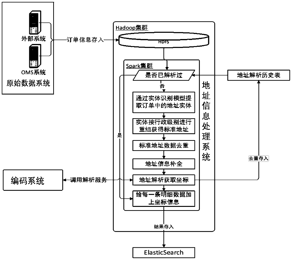
[0068] Such as figure 1 Shown is a system architecture diagram of the present application, which includes a raw data system, an address information processing system, and an encoding system that can exist independently of each other on hardware. The raw data system is used for raw data systems that provide raw data, such as external systems or OMS (order management) systems. The address information processing system is used to obtain original data such as order information from the original data system, and perform a series of processing on the address information of the original data to obtain geographic data in a standard form. The encoding system is used to encode the geographic data in the standard form to obtain geocoding results (usually coordinates). The coding system is encapsulated with a batch analysis interface, and the address information processing system can complete the coding of standard geographical data by calling the batch analysis interface of the coding s...
Embodiment 2
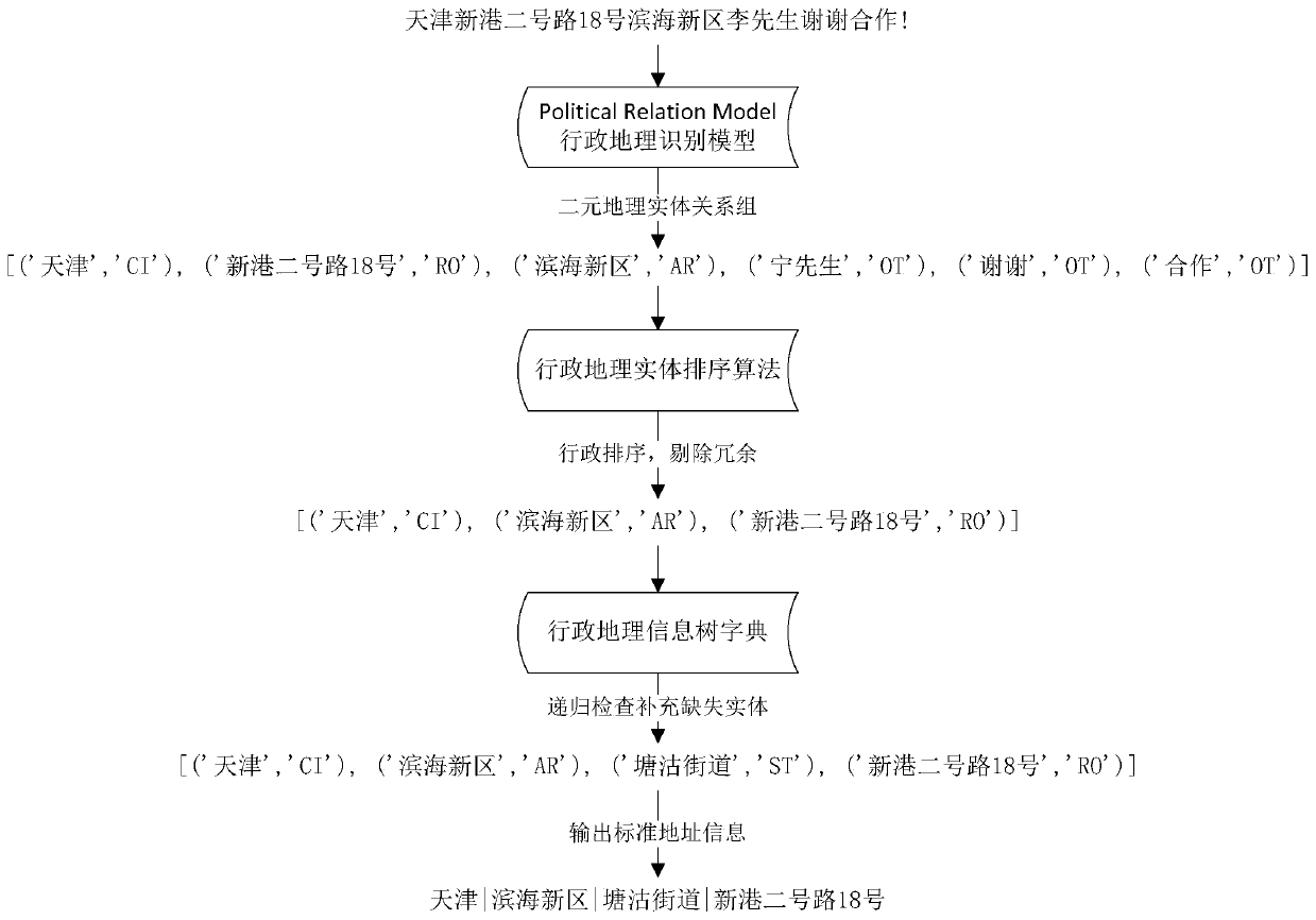
[0134] Based on the above description, Embodiment 2 of the present application provides a method for parsing address information, such as image 3 As shown, the method includes:
[0135] S31 acquires address information to be resolved in the original data;
[0136] S32 Use natural language processing technology to perform feature extraction and selection on the address information to be parsed, and vectorize the selected features to obtain a feature vector to be recognized; for specific methods, refer to the steps of feature extraction selection and vectorization in model training.
[0137] S33 Input the feature vector to be identified into the preset model to obtain an initial array including the geographic entity and the administrative division level corresponding to the geographic entity;
[0138] S34 sort and deduplicate the geographic entities in the initial array according to the administrative division level to obtain a standard array;
[0139] S35 encodes the standar...
Embodiment 3
[0162] Based on the above-mentioned associative storage, and taking the request to obtain relevant data within a certain geographical range as an example, the present application provides a third embodiment to provide a data acquisition method, including:
[0163] Receive candidate address information;
[0164] Analyzing the candidate address information according to the above-mentioned address resolution method to obtain parsed candidate geocoding data;
[0165] According to the candidate geocoding data and the preset geographic range, calculation is performed in the prestored association table of the geocoding result and the original data, and the geocoding result and the corresponding raw data within the preset geographic range are obtained.
[0166] Through the above method, the geocoding results can be used to obtain raw data within a certain geographical range, which provides a data basis for subsequent sales, promotion, and other decisions.
PUM
 Abstract
Description
Claims
Application Information
 - R&D
- Intellectual Property
- Life Sciences
- Materials
- Tech Scout
- Unparalleled Data Quality
- Higher Quality Content
- 60% Fewer Hallucinations
Browse by: Latest US Patents, China's latest patents, Technical Efficacy Thesaurus, Application Domain, Technology Topic, Popular Technical Reports.
© 2025 PatSnap. All rights reserved.Legal|Privacy policy|Modern Slavery Act Transparency Statement|Sitemap|About US| Contact US: help@patsnap.com


