Quantitative detection method for urbanized vegetation effect effective distance

A detection method and effective distance technology, applied in the field of remote sensing data data analysis, can solve the problems of uncertainty in accuracy and precision, inconsistent results, lack of detection methods, etc., and achieve the effect of good robustness and high precision

Inactive Publication Date: 2019-10-25
CHINESE RES ACAD OF ENVIRONMENTAL SCI
View PDF3 Cites 11 Cited by
  • Summary
  • Abstract
  • Description
  • Claims
  • Application Information

AI Technical Summary

Problems solved by technology

[0005] It can be seen that there is a lack of detection methods for the effective distance of the impact of urbanization on the ecosystem at present, the results obtained

Method used


Image

  • Quantitative detection method for urbanized vegetation effect effective distance
  • Quantitative detection method for urbanized vegetation effect effective distance
  • Quantitative detection method for urbanized vegetation effect effective distance

Examples


Embodiment

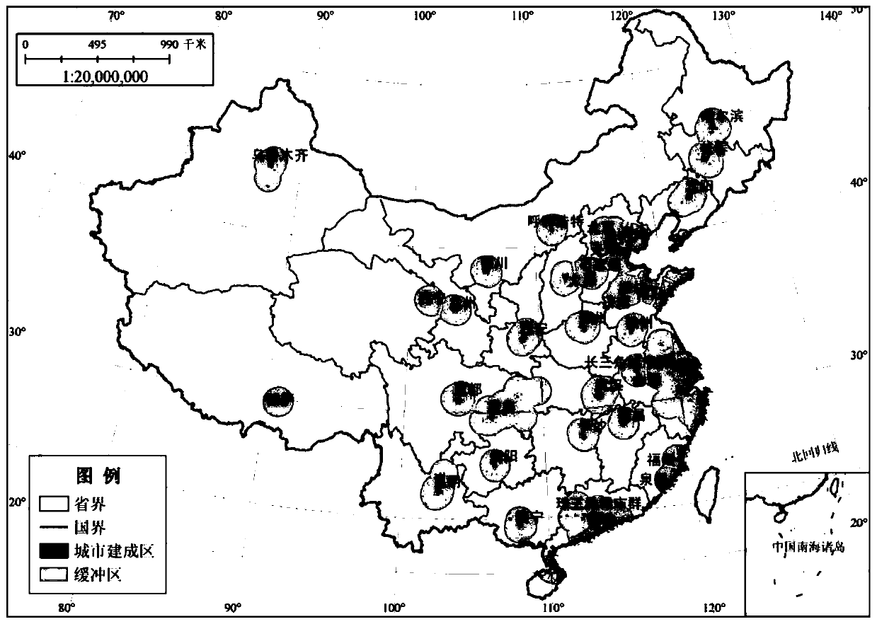
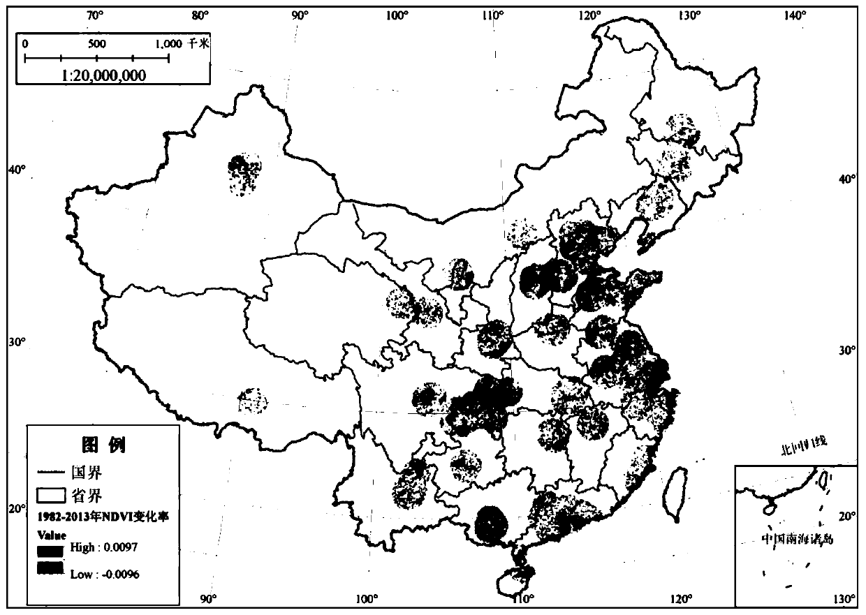
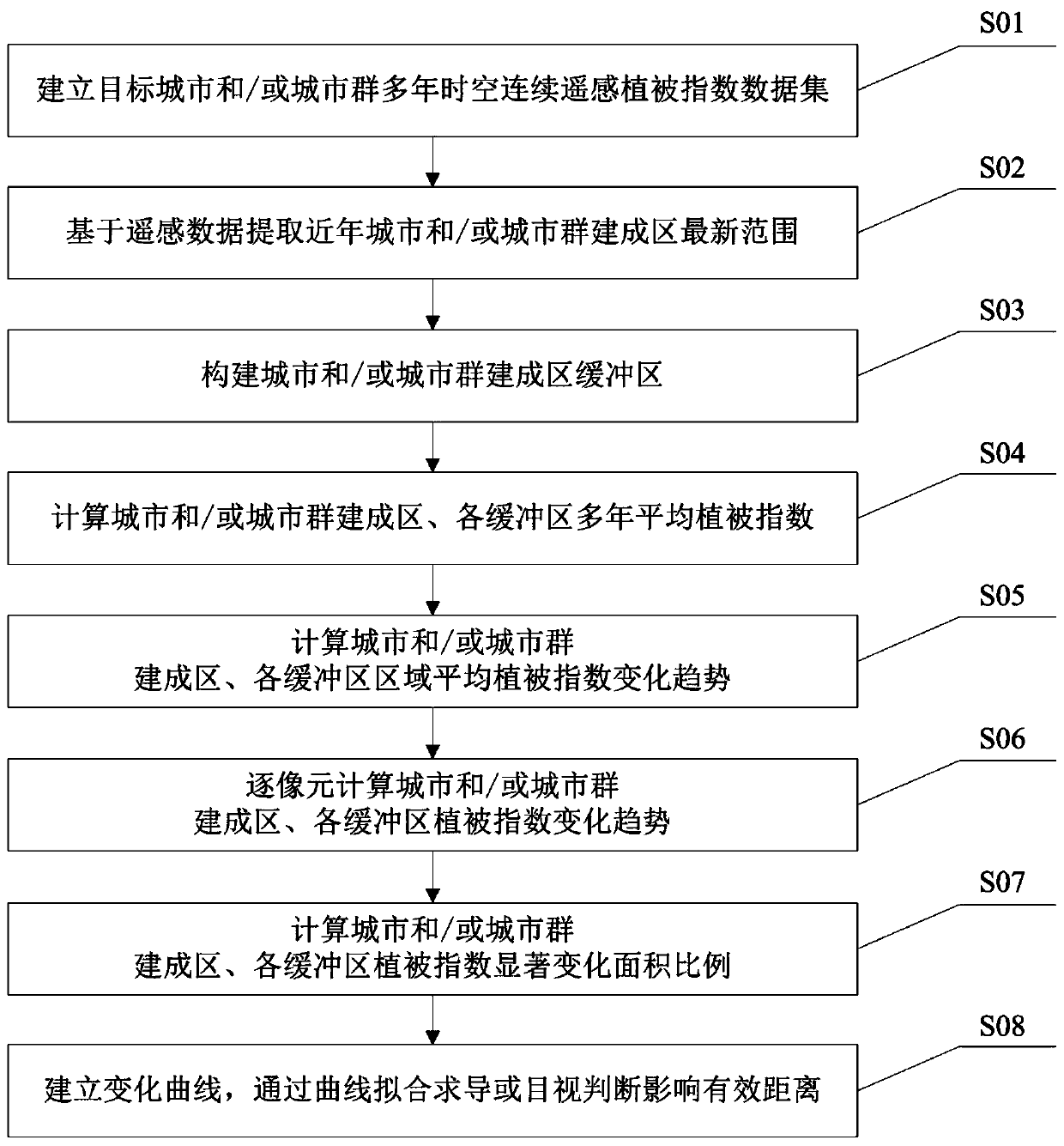
[0063] combined with figure 1 , the quantitative detection method of the effective distance of urbanization vegetation effect is elaborated in detail, and the specific steps are as follows:

[0064] S01: Establish a multi-year space-time continuous remote sensing vegetation index dataset for cities and urban agglomerations

[0065] Specific: Select the 8km AVHRR GIMMMS NDVI produced by the NASA Goddard Space Center Global Monitoring and Simulation Research Group in 15 days 3g (3g: refers to the third-generation AVHRR GIMMS data set) The data set is used as vegetation index data, and the time span is 1982-2013, where NDVI 3g The data undergoes preprocessing processes such as subset extraction, image mosaicing, cropping data, format conversion, projection conversion, and quality inspection; the monthly value data set of vegetation index is obtained through the maximum value synthesis MVC method, and the average monthly value of the vegetation index in the growing season from Ap...


PUM


Abstract

The invention discloses a quantitative detection method for urbanized vegetation effect effective distance. The quantitative detection method comprises the following steps: establishing a data set ofmulti-year space-time continuous remote sensing vegetation indexes of cities/urban groups; extracting the latest range of the built-up area of the city/city group based on the remote sensing data; setting a buffer interval of the built-up area based on the spatial resolution of the remote sensing vegetation index; calculating the multi-year average vegetation index of the city/city group built-uparea and the buffer area; calculating a regional average vegetation index change trend; calculating vegetation index change trends of the city/city group built-up area and the buffer area pixel by pixel; calculating a vegetation index significant change area ratio of the city/city group built-up area to the buffer area; establishing three index dynamic change curves, and judging the influence effective distance. The method can realize quantitative detection of the effective distance of the influence of urban construction on vegetation, is simple and easy to use, good in robustness and high inprecision, and provides direct technical support for urban ecological environment protection, urban landscaping, ecological restoration, ecological supervision and the like.

Description

technical field [0001] The invention relates to the technical field of data analysis of remote sensing data, in particular to a quantitative detection method for effective distance of urbanization vegetation effect. Background technique [0002] Urbanization has had a profound impact on ecosystem services and functions, biodiversity, etc., and is considered to be one of the main driving forces of ecosystem change. The impact of urbanization on the ecological system has a "spatial spillover effect", that is, the process of urbanization will not only affect the internal ecological environment of the urban built-up area, but also affect the surrounding ecological environment of the built-up area to a certain extent. Therefore, quantifying the effective impact distance of urban construction on the ecosystem has very important practical value and practical significance for urban development planning, ecological environment protection, delineation of urban development boundaries, ...

Claims


Application Information

Patent Timeline
IPC IPC(8): G06Q10/06G06Q50/26G06K9/00
CPCG06Q10/0639G06Q50/26G06V20/176G06V20/188
Inventor 杜加强付青全占军吴金华
Owner CHINESE RES ACAD OF ENVIRONMENTAL SCI
Why Eureka
Try Eureka