
Method and system for automatic processing of geochemical survey vector data based on mapgis

A vector data, geochemical technology, applied in image data processing, still image data in vector format, still image data retrieval, etc.

Active Publication Date: 2020-08-07
CHINA UNIV OF GEOSCIENCES (WUHAN)
View PDF4 Cites 0 Cited by
  • Summary
  • Abstract
  • Description
  • Claims
  • Application Information

AI Technical Summary

Problems solved by technology

[0003] The technical problem to be solved by the present invention is to provide a method and system for automatic processing of geochemical survey vector data based on MapGIS in view of the defects that require a large amount of manual processing work in the prior art

Method used


Image

  • Method and system for automatic processing of geochemical survey vector data based on mapgis

Examples


Embodiment Construction

[0074] In order to have a clearer understanding of the technical features, purposes and effects of the present invention, the specific implementation manners of the present invention will now be described in detail with reference to the accompanying drawings.

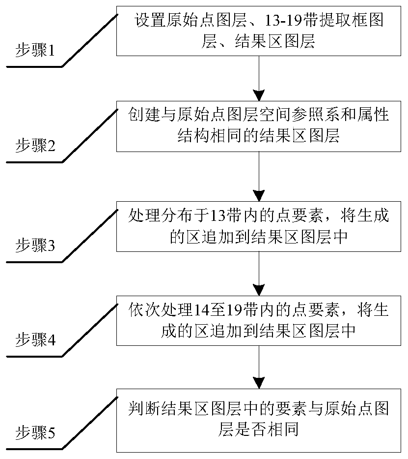
[0075] The following will take the five northwestern provinces as an example. The five northwestern provinces specifically refer to: Shaanxi Province, Gansu Province, Qinghai Province, Ningxia Hui Autonomous Region, and Xinjiang Uygur Autonomous Region. The five northwestern provinces are distributed in the 13-19 degree zone. Such as figure 1 as shown, figure 1 It is a flow chart of an automatic processing method for geochemical survey vector data in five provinces in Northwest China provided by the present invention. It is run on MapGIS software as an example, and the method includes the following steps:

[0076] Step 1: Set the original vector point layer path, 13 vector layer path with extraction frame, 14 vector la...


PUM


Abstract

The invention discloses an automatic processing method and a system for geochemical survey vector data based on MapGIS. At first, that original point map lay of the vector data of the regional geochemical survey to be processed is arrange, Each zoning extracts the block diagram layer and the result vector area layer, and then the original point map layer is clipped by using the vector layer of each zoning extracting frame in turn, projection transformation and automation processing of point transfer area, and finally the final vector area map layer of regional geochemical investigation to be processed is obtained. The most obvious difference of the invention is that the automation of the whole process of the geochemical survey vector data transfer area can be realized. The invention solvesthe problems that the current geochemical survey vector data transfer area needs manual processing and the work efficiency is low. The invention can save a large amount of human cost for the real-time network sharing and publishing of geochemical survey result maps, and improves the timeliness of the result data publishing. The invention also solves the problems that the geochemical survey vectordata transfer area needs manual processing and low work efficiency.

Description

technical field [0001] The invention relates to vector data automatic processing technology, in particular to a method and system for automatic processing of geochemical survey vector data based on MapGIS. Background technique [0002] Data mapping of geochemical survey results is a necessary process for results sharing and network publishing, and network publishing needs to scale the result data, and point elements cannot correctly express the true meaning of each working point in geochemical surveys when displayed at a high level. Point features need to be converted into district features, and two adjacent districts must also be seamlessly connected without gaps in between. To correctly express the meaning of geochemical survey, each zone must represent a space range of 2 square kilometers. The sampling points of geochemical survey are generally carried out in the plane coordinate system. The point elements in each zone are converted into 2km*2km square area elements, so ...

Claims


Application Information

Patent Timeline
Patent Type & Authority Patents(China)
IPC IPC(8): G06F16/56G06T11/00
CPCG06T11/003
Inventor 郭明强黄颖刘拓魏东琦高婷赵禹刘袁缘
Owner CHINA UNIV OF GEOSCIENCES (WUHAN)
Learn More