A verticality detection method of communication tower based on UAV video

A detection method and technology for communication towers, which are applied in photogrammetry/video surveying, radio wave measurement systems, measurement devices, etc., can solve problems such as economic losses of construction enterprises and individuals, low detection efficiency, errors, etc., and improve measurement Reliability, reduced labor costs, and the effect of reducing measurement errors

Active Publication Date: 2020-12-01
杭州艾航科技有限公司
View PDF5 Cites 0 Cited by
  • Summary
  • Abstract
  • Description
  • Claims
  • Application Information

AI Technical Summary

Problems solved by technology

The traditional method of using artificial climbing towers to measure relevant parameters has faced many problems, such as extremely cold and extremely hot weather, installation location, safety, efficiency, labor costs, etc., accompanied by high-altitude operations, which are prone to serious personal casualties. , it will bring huge economic losses to construction enterprises and individuals, even at the cost of life
[0003] Problems and shortcomings of the existing technology: the verticality measurement of the traditional communication tower adopts the artificial ground measurement method, which is limited by the terrain and terrain, and the observation angle of the communication tower is limited by this method; due to the limitation of observation, repeated measurement at different angles is difficult to achieve
However, a single measurement of a single angle may bring a large error, the error is 2-5 degrees; at the same time, there is also the problem that the verticality of the communication tower cannot be quickly and accurately judged, the detection efficiency is low, and the time and labor costs are high.

Method used


Image

  • A verticality detection method of communication tower based on UAV video
  • A verticality detection method of communication tower based on UAV video
  • A verticality detection method of communication tower based on UAV video

Examples


Embodiment Construction

[0024] The embodiments of the present invention will be further described below. The following examples only further illustrate the present application, and should not be construed as limiting the present application.

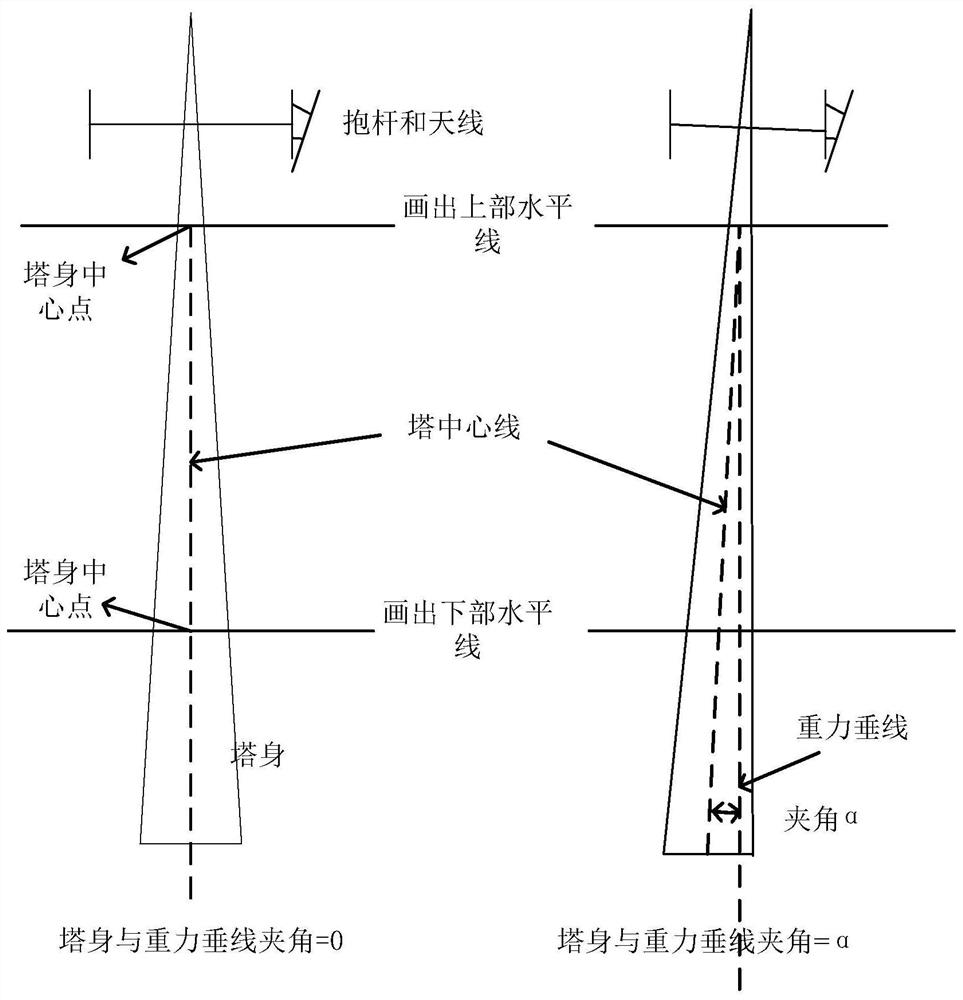
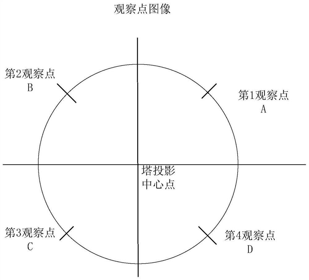
[0025] Such as figure 1 , figure 2 As shown, a communication tower verticality detection method based on UAV video, the specific implementation steps are as follows:

[0026] 1) Use the multi-rotor UAV to fly around the communication tower at a fixed point with the center of the tower projection center and a horizontal circle with an equidistant radius, and take a video of the communication tower. Among them, the UAV has its own gyroscope and camera. , Gravity direction self-calibration is stable; the flying radius of this embodiment is 10 meters.

[0027] 2) For the video preprocessing of flying around, intercept the whole video frame image of flying around 360° at a horizontal uniform speed, and obtain the angular velocity of flying around; wherein, the f...


PUM


Abstract

The present invention proposes a method for detecting the verticality of a communication tower based on the UAV video, which uses the UAV to fly around the communication tower at a fixed point and shoots the video; preprocesses the video of the flying around, and intercepts 360° video frames that fly around at a horizontal and uniform speed image, obtain the angular velocity of the flight; divide the circle of the flight into 4 quadrants, select 1 observation point in each of the 4 quadrants, and the 4 observation points are separated by an angle of π / 2; intercept the video frame of each observation point, and Two horizontal lines are drawn at the upper and lower ends of the communication tower, and the center line perpendicular to the two horizontal lines is the center line of the tower. The angle between the center line of the tower and the gravity vertical line is the verticality of the tower measured at an observation point; two orthogonal The verticality of the tower in the direction is γ and β, then the tangent of the final verticality α of the communication tower can be calculated according to the following formula: Then use the arc tangent function arctan to obtain the verticality α of the communication tower. The invention uses the drone to fly around the communication tower at a fixed point to shoot video, and through computer software processing, the accuracy and efficiency are improved, and the labor cost is reduced.

Description

technical field [0001] The invention relates to the technical field of communication tower maintenance, in particular to a method for detecting verticality of communication towers based on drone video. Background technique [0002] Correct installation and maintenance testing of antennas on wireless communication base station towers is an important part of mobile communication engineering construction and operation. The traditional method of using artificial climbing towers to measure relevant parameters has faced many problems, such as extremely cold and extremely hot weather, installation location, safety, efficiency, labor costs, etc., accompanied by high-altitude operations, which are prone to serious personal casualties. , It will bring huge economic losses to construction enterprises and individuals, even at the cost of life. [0003] Problems and shortcomings of the existing technology: the verticality measurement of the traditional communication tower adopts the man...

Claims


Application Information

Patent Timeline
Patent Type & Authority Patents(China)
IPC IPC(8): G01C11/36G01C9/00
CPCG01C9/005G01C11/00G01C11/36
Inventor 潘晨周永霞
Owner 杭州艾航科技有限公司
Why Eureka
Try Eureka