A method and system for stratified and refined prediction of adjacent grid temperature
A technology of temperature stratification and prediction method, applied in design optimization/simulation, calculation, computer-aided design, etc., can solve problems such as disconnection, calculation result error, difficult numerical model, etc., to improve vertical temperature resolution and calculation speed. Fast, accurate results
- Summary
- Abstract
- Description
- Claims
- Application Information
AI Technical Summary
Problems solved by technology
Method used
Image
Examples
Embodiment 1
[0020] This embodiment discloses a layered and refined prediction method for adjacent grid temperatures, including:
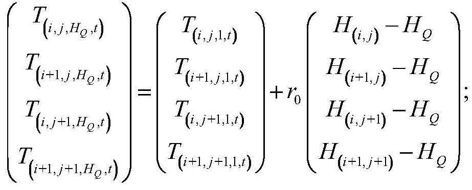
[0021] Determine the calculation grid of the three-dimensional temperature field, calculate the temperature data of each grid point in the three-dimensional temperature field based on the meteorological WRF numerical model, and calculate the vertical temperature lapse rate between adjacent grids in the vertical direction; wherein, the grid The horizontal plane represents latitude and longitude, and the vertical direction represents altitude;
[0022] According to the longitude and latitude of the dancing points to be analyzed, determine the associated series of grids in the vertical direction, and perform uniform layering on the series of grids. The grid height in the vertical direction is Δz, the layer height in the vertical direction is Δ1, and Δz / Δl is an integer greater than or equal to 2;
[0023] Calculate the temperature of the ground altitude correspo...
Embodiment 2
[0075] Corresponding to the above method embodiments, this embodiment discloses a layered and refined prediction system for adjacent grid temperatures, including:
[0076] The first calculation unit: the calculation grid used to determine the three-dimensional temperature field, calculate the temperature data of each grid point in the three-dimensional temperature field based on the meteorological WRF numerical model, and calculate the vertical temperature drop rate between adjacent grids in the vertical direction ; Wherein, the horizontal plane of the grid represents latitude and longitude, and the vertical direction represents altitude.
[0077] The second calculation unit: used to determine the associated series of grids in the vertical direction according to the latitude and longitude of the dancing point to be analyzed, and perform uniform layering on the series of grids. The height of the grid in the vertical direction is Δz, and the layer in the vertical direction The h...
PUM
 Abstract
Description
Claims
Application Information
 - Generate Ideas
- Intellectual Property
- Life Sciences
- Materials
- Tech Scout
- Unparalleled Data Quality
- Higher Quality Content
- 60% Fewer Hallucinations
Browse by: Latest US Patents, China's latest patents, Technical Efficacy Thesaurus, Application Domain, Technology Topic, Popular Technical Reports.
© 2025 PatSnap. All rights reserved.Legal|Privacy policy|Modern Slavery Act Transparency Statement|Sitemap|About US| Contact US: help@patsnap.com


