
Integrated framework and integration method for multi-source heterogeneous geographic information resources

A geographic information, multi-source heterogeneous technology, applied in geographic information databases, structured data retrieval, electronic digital data processing, etc., can solve problems such as inapplicability to large-scale systems, inapplicability, performance problems, etc.

Active Publication Date: 2017-06-13
中国科学院电子学研究所苏州研究院
View PDF3 Cites 17 Cited by
  • Summary
  • Abstract
  • Description
  • Claims
  • Application Information

AI Technical Summary

Problems solved by technology

[0005] 1. Defects such as the performance and single function of Web Service are gradually revealed
Whether it is in terms of network bandwidth or CPU overhead, it will cause serious performance problems for applications, so that this technology cannot be applied to many systems that require high performance and interoperability.
[0006] 2. CORBA and DCOM are difficult to be widely promoted due to their complex technical standards and shortcomings in platform compatibility
[0007] 3. RMI is a remote call of the Java language. The programming language at both ends must be implemented in Java, which cannot support mutual communication between different languages.
However, there is no unified technical standard for these methods, and there are various restrictions, so they are not suitable for large-scale systems.
[0012] In addition, previous resource integration frameworks mainly focused on the integration of service resources and database resources, and did not provide rigorous and usable implementation solutions for the transmission of message resources and unstructured data resources.
[0013] To sum up, in terms of service invocation, message communication, data synchronization and data transmission between heterogeneous environments, the current geographic information resource sharing platform does not have a complete set of solutions and framework systems

Method used


Image

  • Integrated framework and integration method for multi-source heterogeneous geographic information resources
  • Integrated framework and integration method for multi-source heterogeneous geographic information resources
  • Integrated framework and integration method for multi-source heterogeneous geographic information resources

Examples


Embodiment Construction

[0073] The present invention will be further described in detail below in conjunction with the accompanying drawings and specific preferred embodiments.

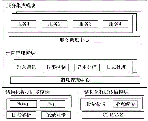
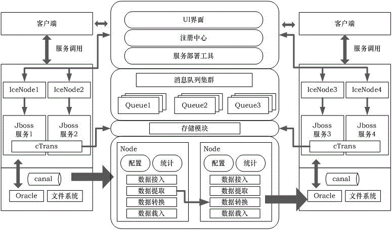
[0074] like figure 1 and figure 2 As shown in , an integrated framework for multi-source heterogeneous geographic information resources includes four modules and a lightweight J2EE framework that integrates the four modules. The lightweight J2EE framework is a relatively mature existing technology, and will not be described in detail here.

[0075] The four modules are service integration module, message management module, structured data synchronization module and unstructured data transmission module.

[0076] The service integration module utilizes ICE middleware technology to develop and deploy distributed applications and realize remote invocation of services. like figure 1 As shown, the service integration module has multiple services, such as service 1, service 2, service 3, and service 4. The service scheduling ...


PUM


Abstract

The invention discloses an integrated framework and integration method for multi-source heterogeneous geographic information resources. The integrated framework comprises a service integration module, a message management module, a structured data synchronization module, an unstructured data transmission module and a light-weight J2EE framework that integrates the four modules. The invention provides a modular distributed information resource sharing technology solution mainly aiming at the massive multi-source heterogeneous geospatial data and geographic information services. Based on the acquisition means, distribution positions, structural characteristics and other factors of the resources in the existing geographic information fields, corresponding scheme modules are designed and achieved from the aspects of cross-domain data entity transmission, distributed geographic information synchronization, remote service invocation, multi-dimensional platform message management and the like, and thus a set of complete geographic information heterogeneous resource integration framework can be achieved, the problem of calling, transmitting and synchronizing the services, messages, structured data and unstructured data between different platforms can be solved, the utilization efficiency of the networked resources can be increased, and the sharing cost of the resources can be reduced.

Description

technical field [0001] The invention relates to the technical field of geographic information, in particular to an integration framework and an integration method for multi-source heterogeneous geographic information resources. Background technique [0002] In recent years, with the high informatization of production and life, geographic information services have gradually become the basic modules for various services in the fields of public transportation, social platforms, shopping and entertainment, smart cities, and government decision-making. Various industries and departments have accumulated a large number of geographic information-related resources and service applications, but due to the lack of effective resource integration methods, a large number of "resource islands" have been formed, resulting in waste of resources and unnecessary redundant construction. [0003] In order to improve the utilization efficiency of geographic information resources and reduce produ...

Claims


Application Information

Patent Timeline
IPC IPC(8): H04L29/08G06F17/30G06F9/445
CPCH04L67/1095H04L67/1097H04L67/2866H04L67/30G06F9/44505G06F16/20G06F16/29G06F16/30H04L67/562H04L67/52H04L67/60
Inventor 丁赤飚付琨胡岩峰朱利鲁丁士伟张伟刘振吴亚军
Owner 中国科学院电子学研究所苏州研究院
Learn More