
GNSS (Global Navigation Satellite System) receiver simulator and gravity field inversion system

A technology of simulator and receiver, which is applied in the field of satellite navigation, can solve the problems of not being able to provide dynamic high-precision time-delay simulation, and the accuracy of simulated on-orbit distance is not high, and achieve real-time orbit determination and on-orbit time synchronization. Effect

Inactive Publication Date: 2016-05-25
SPACE STAR TECH CO LTD
View PDF3 Cites 13 Cited by
  • Summary
  • Abstract
  • Description
  • Claims
  • Application Information

AI Technical Summary

Problems solved by technology

Through research and demonstration, it is found that the RF digital analog on-orbit distance delay simulator in the prior art cannot provide dynamic and high-precision delay simulation, so it is difficult for KBR (K-band ranging) equipment to be directly integrated into the analog observation data generation of KBR and GNSS In the simulator, and the accuracy of the simulated on-orbit distance is not high

Method used


Image

  • GNSS (Global Navigation Satellite System) receiver simulator and gravity field inversion system
  • GNSS (Global Navigation Satellite System) receiver simulator and gravity field inversion system
  • GNSS (Global Navigation Satellite System) receiver simulator and gravity field inversion system

Examples


Embodiment 1

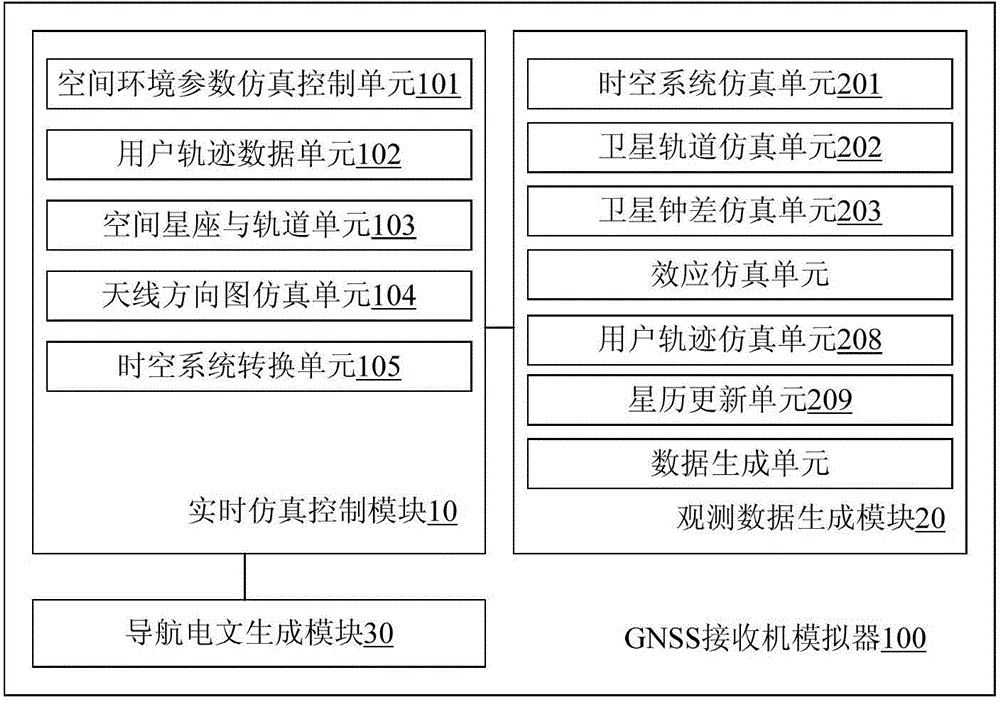
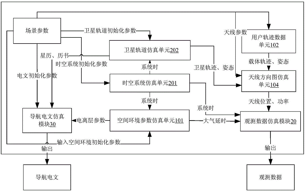
[0053] Such as figure 1 Shown is a schematic structural diagram of a GNSS receiver simulator provided by an embodiment of the present invention, combined with figure 2 As shown, the hardware of the GNSS receiver simulator 100 is composed of an industrial control computer and two parts of 422 interfaces respectively used for RS422 serial communication. The digital simulation software of the GNSS receiver simulator 100 runs on the aforementioned industrial control computer. The GNSS receiver simulator 100 specifically includes: a real-time simulation control module 10 and an observation data generation module 20.

[0054] The real-time simulation control module 10 includes: a space environment parameter simulation unit 101, a user trajectory data unit 102, a space constellation and orbit unit 103, an antenna pattern simulation unit 104, a spatio-temporal system conversion unit 105, and a navigation message generation unit 106.

[0055] Specifically, the space environment parameter si...

Embodiment 2

[0080] Such as Figure 4 Shown is a schematic structural diagram of a gravity field inversion system provided by another example of the present invention, combined with Figure 5 As shown, the gravity field inversion system 1000 includes the GNSS receiver simulator 100 in the foregoing embodiment 1, and also includes a level 0 data processor 200. The level 0 data processor 200 specifically includes: a GNSS1A level data processing module 50 and a GNSS1B Level data processing module 40.

[0081] Among them, the GNSS1A-level data processing module 50 is used to extract relevant data in the 0-level observation data of A or B stars, that is, GNSS1A-level data, including time scale, available star information, pseudorange, carrier phase, Doppler and other information , And sent to the GNSS1B-level data processing module 40, which is also used to detect the continuity of time based on the extracted information, and repair the lost frame and repeated frame data. The GNSS1B-level data pro...


PUM


Abstract

The invention discloses a GNSS (Global Navigation Satellite System) receiver simulator and a gravity field inversion system. The GNSS receiver simulator comprises a real-time simulation control module and an observation data generation module, wherein the real-time simulation control module is used for acquiring position information of a satellite and position information of a user based on the received orbital data, the gravity parameters and the atmospheric parameter, simulating error information on a satellite signal by the ionosphere, the troposphere and multipath effects and sending the position information of the satellite, the position information of the user and the error information to the observation data generation module; and the observation data generation module is used for generating observation data for the satellite based on the position information and the error information sent by the real-time simulation control module. The GNSS receiver simulator can realize an on-orbit time synchronization function and a real-time orbit determination function, the orbit determination precision is high and is no more than 50 m.

Description

Technical field [0001] The invention relates to the technical field of satellite navigation, in particular to a global satellite navigation system (Global Navigation Satellite System, GNSS) receiver simulator for demonstration and verification of the gravity field recovery of a low-tracking satellite gravity measurement system and a gravity field including the GNSS receiver simulator Inversion system. Background technique [0002] The low-low-tracking gravity satellite project can quickly obtain the midfield wave information of the global earth's gravity field, and can achieve the micron-level measurement accuracy of the offset distance between the stars. It has become the subject of geophysics, geodesy, hydrology, oceanography, and even disaster prevention and mitigation A high-tech method and a research hotspot in the field of international gravity measurement. This method mainly uses low-orbit satellites as sensors for the earth's gravity field, and retrieves the gravity fiel...

Claims


Application Information

Patent Timeline
IPC IPC(8): G01S19/40G01S19/07G01S19/14
Inventor 李醒华陈潇何俊秀蔡乐毕亮郝庆畅郭大军刘锡忠邹国际
Owner SPACE STAR TECH CO LTD
Learn More