
Integrated batch drawing method of remote-sensing image and vector data

A remote sensing image and vector data technology, applied in image data processing, 2D image generation, image analysis, etc., can solve the problems of lack of integrated batch segmentation and cropping of image data and vector data, limiting map production efficiency, etc. Flexibility and reusability, productivity-enhancing effects

Active Publication Date: 2013-05-08
武汉中地数码科技有限公司 +2
View PDF1 Cites 30 Cited by
  • Summary
  • Abstract
  • Description
  • Claims
  • Application Information

AI Technical Summary

Problems solved by technology

[0003] Many existing GIS and remote sensing software provide standard framing and cropping of data, but few of them can perform standard framing and batch cropping, let alone integrated batch framing and cropping of image data and vector data
In addition, the cropping and mapping work in the existing system is handled separately, which greatly limits the production efficiency of the map

Method used


Image

  • Integrated batch drawing method of remote-sensing image and vector data
  • Integrated batch drawing method of remote-sensing image and vector data
  • Integrated batch drawing method of remote-sensing image and vector data

Examples


Embodiment Construction

[0058] In order to further understand the features, technical means, and achieved specific objectives and functions of the present invention, the present invention will be further described in detail below in conjunction with the accompanying drawings and specific and implementation methods.

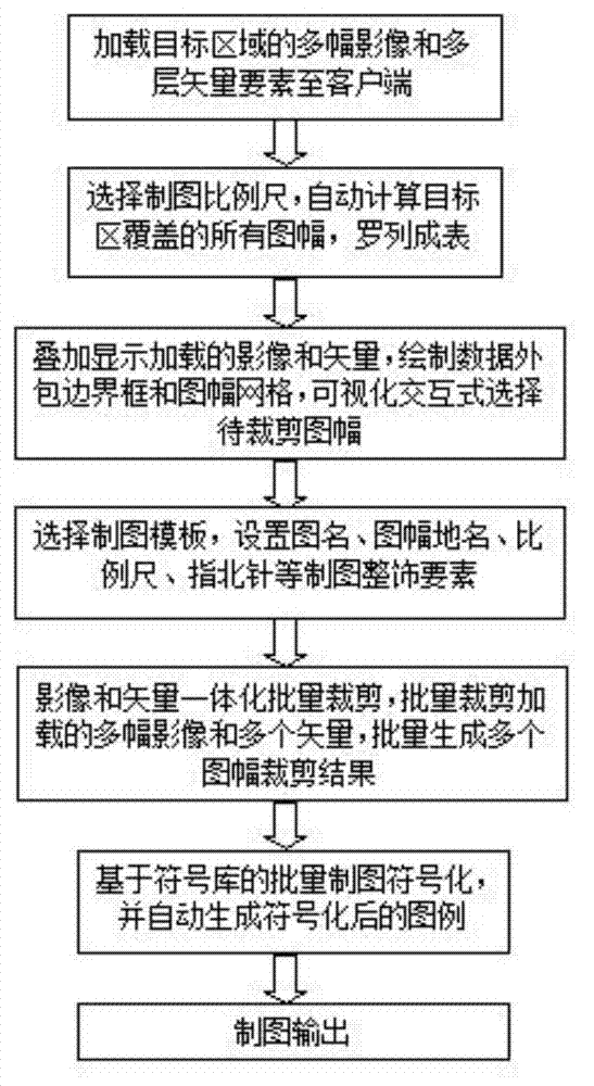
[0059] refer to figure 1 According to an embodiment of the present invention, a method for integrated batch mapping of remote sensing images and vector data comprises the following steps:

[0060] Step 1. Load multiple images and multi-layer vector elements of the target area; manually select about 5 corresponding points on the remote sensing image and vector map respectively, and establish the affine transformation relationship between the remote sensing image and the ground plane coordinates; The vector map data is projected onto the remote sensing image by the projective transformation, which is used as the initial value of linear information extraction on the remote sensing image; t...


PUM


Abstract

The invention relates to a method of clipping and drawing, in particular to an integrated batch drawing method of a remote-sensing image and vector data. The integrated batch drawing method is characterized by comprising the following steps: step 1, a plurality of images and a plurality of layers of vector elements in a target area are loaded; step 2, drawing measuring scale is chosen, all map sheets coated by the target area are calculated and listed in table; step 3, loaded images and vectors are displayed in an overlapping mode, data outsourcing bounding boxes and sheet grids are drawn, a to-be-clipped map sheet is chosen in a visual interactive mode; step 4, a drawing moldboard is made, drawing whole decorative elements such as an image title, a map sheet place name, measuring scales and a compass are set; step 5, the images and the vectors are clipped in an integrated batch mode; step 6, batch drawing is signified based on a symbol library, and graphic symbols are generated automatically after the signifying; and step 7, the drawn map is outputted. The integrated batch drawing method of the remote-sensing image and the vector data improves the working efficiency of standard amplitude selection drawing.

Description

technical field [0001] The invention relates to a method for cropping and mapping, in particular to a method for integrating remote sensing images and vector data into batch mapping. Background technique [0002] Maps are the main form of expression and an important means of analysis and research of earth science observation and survey research results. Digital mapping is to process, analyze and display data through some digital processing methods, and finally output graphics. Today, with the rapid development of information technology, digital mapping technology has brought great convenience to people. Compared with traditional manual thematic mapping, digital mapping has the advantages of high efficiency, convenience, and accuracy, and greatly enriches the representation of map symbols, annotations, and colors. With the rapid development of remote sensing, geographic information system and computer technology, the field of cartography has been further expanded. The cart...

Claims


Application Information

Patent Timeline
IPC IPC(8): G06T11/00G06T7/00
Inventor 吴信才谢忠曾文张发勇吴冰樊文有刘福江叶亚琴林伟华陈占龙胡茂胜周林张唯孙杰张上
Owner 武汉中地数码科技有限公司
Learn More