Method and device for reading and processing raster data
A raster data and processing method technology, applied in the field of spatial information services, can solve the problems of low system response speed and low efficiency of obtaining raster data, and achieve the effects of improving response speed, improving data processing efficiency, and saving system resources
- Summary
- Abstract
- Description
- Claims
- Application Information
AI Technical Summary
Problems solved by technology
Method used
Image
Examples
Embodiment Construction
[0050] In order to make the above objects, features and advantages of the present invention more comprehensible, the present invention will be further described in detail below in conjunction with the accompanying drawings and specific embodiments.
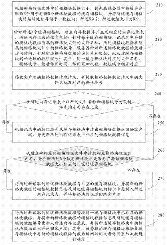
[0051] refer to figure 2 , which shows a schematic flowchart of a method for reading and processing raster data according to the present invention, which may specifically include:
[0052] Step 110, according to the size of the grid block data in the raster data file, pre-allocate the cache in the server as N cache grid blocks for storing N grid block data, and use the identification number to record each cache grid block The starting address of the grid block; the N≥2;
[0053] In this embodiment, the cache can be pre-determined by the server’s raster data service program to determine the total size of the cache used for raster data processing, and then these caches are divided into the entire The cache needs to be divided int...
PUM
 Abstract
Description
Claims
Application Information
 - R&D Engineer
- R&D Manager
- IP Professional
- Industry Leading Data Capabilities
- Powerful AI technology
- Patent DNA Extraction
Browse by: Latest US Patents, China's latest patents, Technical Efficacy Thesaurus, Application Domain, Technology Topic, Popular Technical Reports.
© 2024 PatSnap. All rights reserved.Legal|Privacy policy|Modern Slavery Act Transparency Statement|Sitemap|About US| Contact US: help@patsnap.com


