
Stratus cloud and convective cloud automatic recognition method based on Doppler radar data

A Doppler radar and automatic identification technology, which is applied in the field of meteorological information processing and identification, can solve problems such as heavy workload, large subjective components, and inability to automate

Active Publication Date: 2012-08-08
LANZHOU UNIVERSITY
View PDF1 Cites 21 Cited by
  • Summary
  • Abstract
  • Description
  • Claims
  • Application Information

AI Technical Summary

Problems solved by technology

In 2000, on the basis of the traditional SHY95 method, Michael and Stevenz added the echo vertical profile feature to the method according to the characteristics of the bright band and considering the echo gradient changes in the horizontal and vertical directions, and used data other than radar data. For information on the height of the 0° isotherm, see Biggerstaff, Michael I., Steven A.Listemaa, 2000: An Improved Scheme for Convective / Stratiform Echo Classification Using Radar Reflectivity.J.Appl.Meteor., 39, 2129-2150., This information may not be available in practical applications, and there are certain limitations in its use
However, when this method uses statistical methods to determine the breakpoints of membership functions in the fuzzification process, it needs to use the results of manual identification as the true values ​​of stratus and convective cloud observations.
Therefore, this algorithm cannot be automated, and the workload is large, and there is a large subjective component, which is not easy to use in business
In addition, these algorithms only use one observation of Doppler radar - the echo intensity, lacking other observation information

Method used


Image

  • Stratus cloud and convective cloud automatic recognition method based on Doppler radar data
  • Stratus cloud and convective cloud automatic recognition method based on Doppler radar data
  • Stratus cloud and convective cloud automatic recognition method based on Doppler radar data

Examples


Embodiment Construction

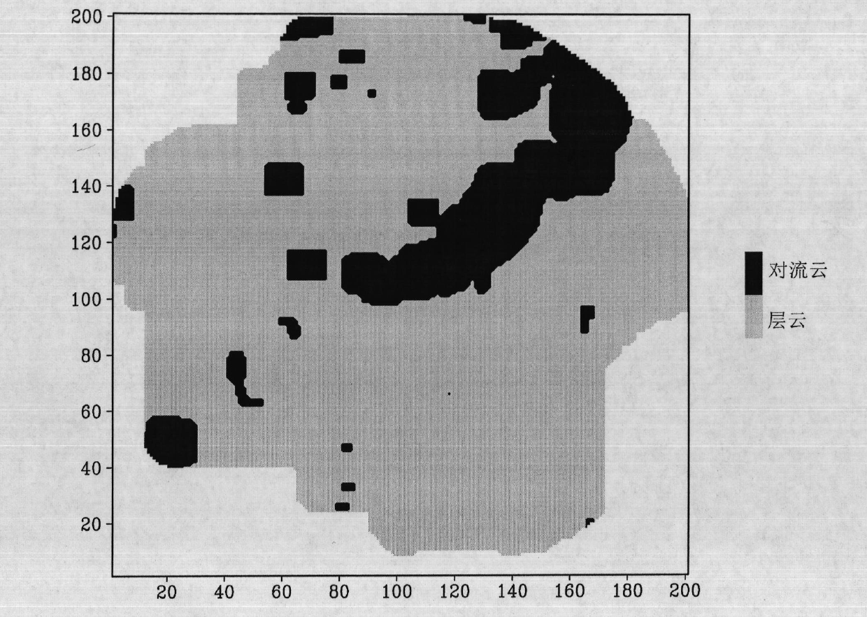
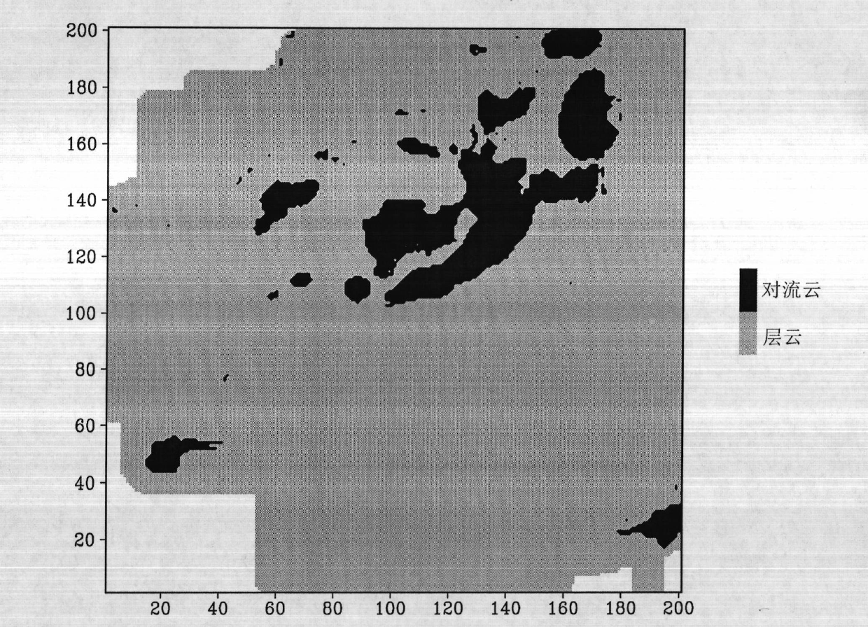
[0057] The present invention provides relevant processing and the example of detection below, and its detected radar data is Nanjing Doppler radar measured data on July 19th, 2006, relevant characteristic parameter and intermediate data are as follows, utilize prior art according to this data simultaneously And the present invention has been processed respectively, and its result has been carried out comparative inspection. The present invention has been compared with the "peak value" method (or called "SHY95" method) commonly used in the world, but the technology of Xiao Yanjiao, Liu Liping and others is not adopted, because their technology has a large subjective component.

[0058] from Figure 2 to Figure 3 It can be seen that the SHY95 method of the prior art and the dynamic fuzzy logic algorithm design result of the present invention are more consistent on the whole and are more consistent with the echo band distribution, especially in figure 2 within the black area of...


PUM


Abstract

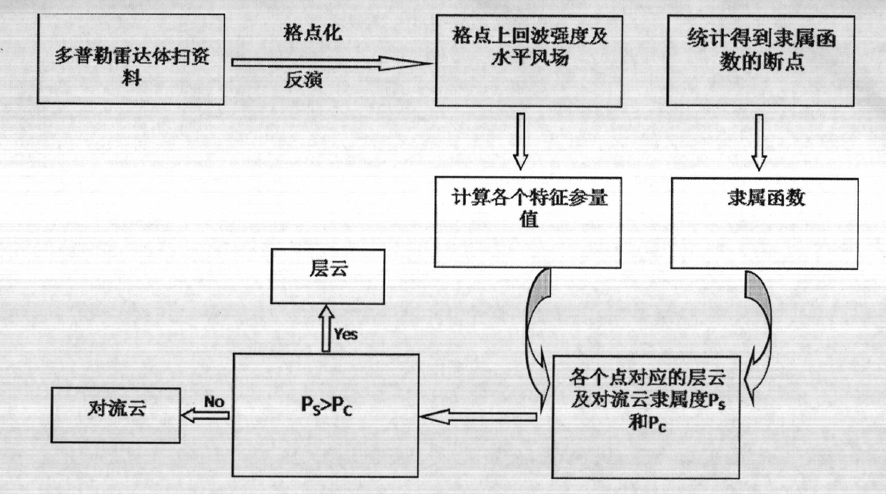
The invention discloses a stratus cloud and convective cloud automatic recognition method based on Doppler radar data. The method includes that actually-measured Doppler radar data of a measured point are interpolated in a three-dimensional rectangular coordinate system, layering is performed according to vertical direction height and vertical grid interval, echo strength and horizontal wind field of each height layer are inverted, and corresponding horizontal divergence is calculated; simultaneously three related characteristic parameters are extracted and calculated; divergence characteristic parameters are calculated and extracted through horizontal gradient inversion wind information with maximum echo strength Zmax, vertical liquid water content VIL and maximum echo strength, membership functions are established, membership degree of each characteristic parameter is calculated, finally Pc and Ps are obtained through summation of membership degrees of the different characteristic parameters corresponding to upper layer could and convective cloud of each horizontal grid point, and when the Pc> the Ps, the measured point is determined to be the convective cloud, otherwise the tested point is stratus cloud.

Description

technical field [0001] The invention relates to a method for processing and identifying meteorological information, specifically a method for processing data measured by a weather radar to determine whether a measured point belongs to a stratus cloud or a convective cloud. Background technique [0002] It is of great help in precipitation estimation in the field of meteorology, monitoring and early warning of disastrous weather, artificial weather modification and the vertical distribution of non-adiabatic process in precipitation area in thermodynamics. Precipitation is directly related to cloud type. [0003] The precipitation system can be divided into convective cloud precipitation and stratiform cloud precipitation from the formation mechanism, duration, and internal structure differences. Convective cloud systems are often accompanied by strong vertical velocity, local convergence and heavy precipitation, while stratiform cloud systems are often accompanied by weak up...

Claims


Application Information

Patent Timeline
IPC IPC(8): G01S13/95
CPCY02A90/10
Inventor 杨毅陈欣
Owner LANZHOU UNIVERSITY
Learn More