Remote-sensing image road network extract method based on improved C-V model

An extraction method and technology of remote sensing images, applied in character and pattern recognition, instruments, computer components, etc., can solve the problems of insufficient speed, efficiency, accuracy, loss of color image color information, and difficulty in guaranteeing segmentation accuracy, etc., to achieve Speed ​​up the road network extraction process, reduce the amount of data processing, and shorten the cycle

Inactive Publication Date: 2011-02-16
ZHEJIANG UNIV
View PDF4 Cites 19 Cited by
  • Summary
  • Abstract
  • Description
  • Claims
  • Application Information

AI Technical Summary

Problems solved by technology

However, the traditional level set C-V model has the following deficiencies: First, it needs to correct the initial curve in iterations, that is, re-initialize the signed distance function, which increases the amount of calculation, reduces the segmentation speed, and is difficult to guarantee the segmentation accuracy; The second is that the division of the region only considers the grayscale characteristics of the RGB space of the image, which loses the rich color information of the color image. Because the phenomenon of fo

Method used


Image

  • Remote-sensing image road network extract method based on improved C-V model
  • Remote-sensing image road network extract method based on improved C-V model
  • Remote-sensing image road network extract method based on improved C-V model

Examples


Embodiment Construction

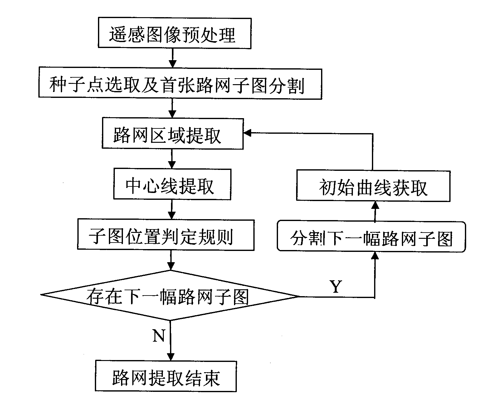
[0042] The present invention will be further described in detail below in conjunction with the accompanying drawings and specific embodiments.

[0043] The following takes the remote sensing image map (provided by QuickBird Company, precision 0.61m) of Zhongshan City, Guangdong Province as an example to specifically illustrate each step of the extraction method of the present invention, and evaluate the road network extraction results with completeness and correctness indicators.

[0044] In order to quantitatively evaluate the road network extraction algorithm, it is necessary to compare the road network area result (Estimate) extracted from the remote sensing image with the road network area result (GT) obtained by actual surveying and mapping, and introduce completeness (c) and correctness (p) Two indicators are evaluated. Equation (2) gives the definitions of completeness (c) and correctness (p) respectively

[0045] c ...


PUM


Abstract

The invention discloses a remote-sensing image road network extract method based on an improved C-V mode, comprising the following steps: (1) pre-processing initial remote-sensing images; (2) selecting seed points and segmenting a first road network subimage; (3) using the level set method of the improved C-V model to extract a road network area; (4) using the method of morphologic detailing to extract the center line of the road network; (5) segmenting the next road network subimage according to the subimage position criterion rule to automatically obtain the road network initial curve according to threshold segmentation and the morphologic method. The method of the invention can be employed to effectively extract the road network from the remote-sensing image, upgrade urban road network in real time and effectively assist decision-makers in formulating traffic planning.

Description

technical field [0001] The invention relates to a method for extracting a road network from a remote sensing map based on a C-V model, and belongs to the application field of high-resolution satellite remote sensing image processing and information extraction. Background technique [0002] With the rapid development of my country's social economy, the process of urbanization continues to accelerate, the urban population and the number of motor vehicles continue to increase, and the contradiction between transportation demand and urban road conditions and capabilities has become increasingly prominent. At present, the phenomenon of traffic congestion in many cities in our country and the social problems such as traffic accidents and traffic environmental pollution caused by it have been extremely serious. As the lifeblood of the city, traffic has become the bottleneck of urban development, seriously restricting the development of society and economy, and affecting the daily w...

Claims


Application Information

Patent Timeline
IPC IPC(8): G06K9/46
Inventor 侯迪波储海兵唐晓芬黄平捷张光新
Owner ZHEJIANG UNIV
Why Eureka
Try Eureka