
Method and apparatus for collection and processing of interferometric synthetic aperture radar data

a synthetic aperture radar and image data technology, applied in the field of synthetic aperture radar image data collection system and method, can solve the problems of decorrelation of sar image data, difficult monitoring and control of relative movements of antennas, and difficulty in obtaining sufficient baselines, so as to avoid interference between space vehicles and minimize decorrelation effects

Inactive Publication Date: 2005-03-08
LOCKHEED MARTIN CORP
View PDF75 Cites 52 Cited by
  • Summary
  • Abstract
  • Description
  • Claims
  • Application Information

AI Technical Summary

Benefits of technology

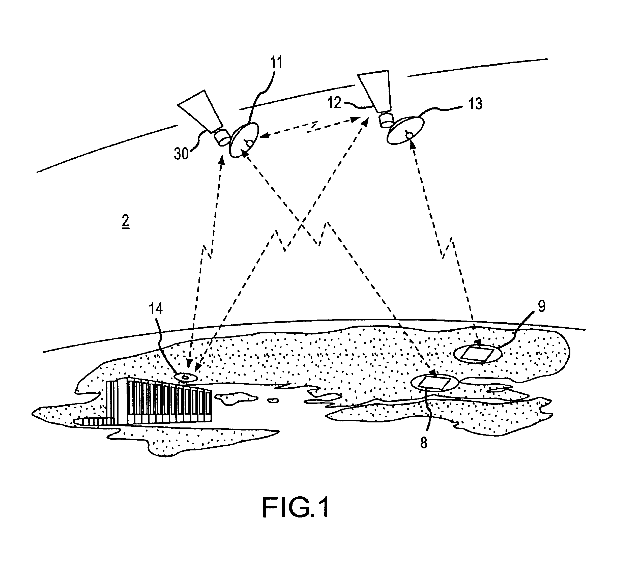
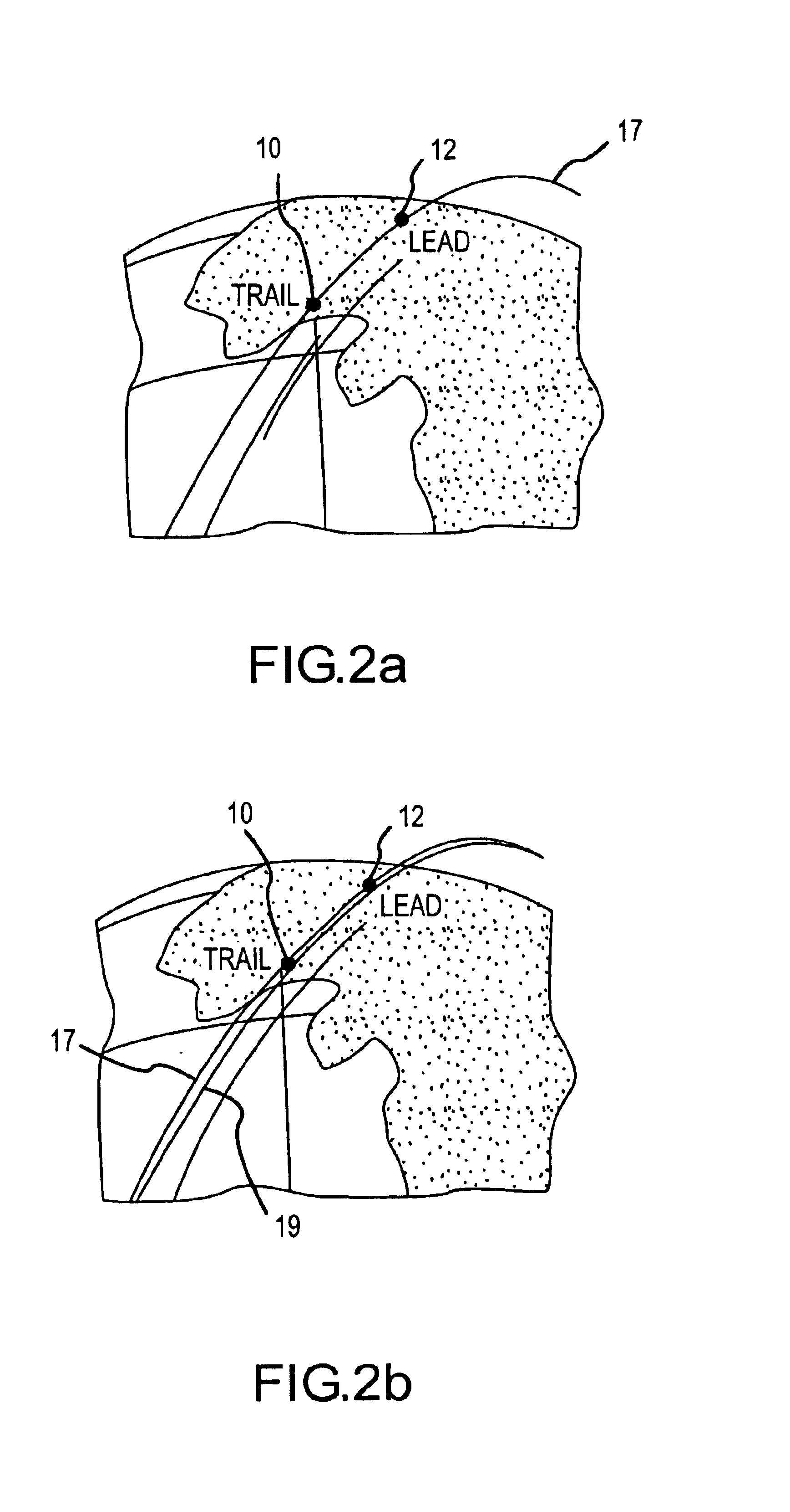
Further included in the system is a second space vehicle moving in an aligned orbital path relative to the space vehicle. The second space vehicle is also configured to emit electromagnetic energy towards the at least one ROI at substantially the same time as the first vehicle and collect the reflected energy. The timing of the relative pulse emissions is controlled to minimize decorrelation effects in a SAR image. The collected energy is then storable as a second image data set for the ROI. Because of the relative proximity of the vehicles while in their orbital track, the system is further configured to control the timing of electromagnetic pulse emission so as to be substantially non-interfering with the image data collection process for each space vehicles.
The central controller described above may be further employable for controlling the relative positions of the first and second space vehicles. Still further, the first and second space vehicles may be configured to collect image data for the at least one ROI from a variety of different grazing angles as well as squint angles. Preferably, the grazing angles may vary between approximately 20 and 48° while the squint angles may vary from approximately 30° to 150°. To minimize decorrelation effects, the radar pulses are separated approximately 10−4 to 10−3 sec, to provide near simultaneous data collection, while at the same time avoiding interference between the space vehicles.

Problems solved by technology

With satellite IFSAR, obtaining sufficiently long baselines can be difficult because it is not practical to connect two space vehicles with booms or tethers of sufficient length, and with unconnected space vehicles, the relative movements of the antennas may be difficult to monitor and control.
It has further been observed that topographic information is not obtainable if the surface of the targeted area moves or changes between the two SAR image data collections causing decorrelation of the SAR image data.
For example, wind can cause branches of trees and bushes to move so that no topographic data can be derived from that part of the scene as a result of the decorrelation.

Method used


Image

  • Method and apparatus for collection and processing of interferometric synthetic aperture radar data
  • Method and apparatus for collection and processing of interferometric synthetic aperture radar data
  • Method and apparatus for collection and processing of interferometric synthetic aperture radar data

Examples


Embodiment Construction

FIG. 1 illustrates an exemplary system embodiment for the present invention. The system includes at least two space vehicles 10 and 12, such as satellites, each having a combination collection and transmission antenna, 11 and 13 respectively, mounted thereon for periodic transmission of electromagnetic energy towards regions of interest (ROI) 8 and 9 on a planetary surface, such as Earth, and the collection of a portion of the reflected energy. Antennas 11 and 13 may be configured for operation in a strip map mode, e.g., where the antennas are positioned relative to the space vehicles to maintain a substantially common path over the ROI's during imaging operations. The strip map mode allows a low cost collection configuration which avoids the need to articulate the antennas as is needed for spotlight imaging. It also gives the large area rate needed for global mapping.

In an exemplary configuration for the nominal mapping mode, the system may produce a three 3-meter along / track (AZIM...


PUM


Abstract

A system and method provide for the collection of interferometric synthetic aperture radar (IFSAR) data. In the system, a first space vehicle configured for emitting electro-magnetic energy and collecting the reflection from a region of interest (ROI), may be directed along a first orbital track. The collected image data may be stored and later provided to a ground station for image and interferometric processing. A second space vehicle may also be configured for emission and collection of electro-magnetic energy reflected from the plurality of ROI's. The second space vehicle is positioned in an aligned orbit with respect to the first space vehicle where the separation between the vehicles is known. In order to minimize decorrelation of the ROI during image processing, the lead and trail satellite are configured to substantially simultaneously emit electromagnetic pulses image data collection. In order to avoid interference in the collection of this image data, each system is configured to control the emission of pulses such that the receipt of direct and bistatic pulses by the other vehicles does not interfere with data collection.

Description

FIELD OF THE INVENTIONThe present invention relates to a system and method for collecting image data for synthetic aperture radar interferometry (IFSAR), and more particularly to the positioning and operation of a plurality of space vehicles configured to collect image data for IFSAR processing.BACKGROUND OF THE INVENTIONInterferometric SAR systems on aircrafts have long been used to make height maps of the earth's surface. Typically the aircraft flies over a targeted region along a flight track to collect data. An antenna on the aircraft transmits electro-magnetic pulses, which are reflected off the target area and then received by the antenna using a signal receiver. The image data collected by each antenna is then used to create a two dimensional image of the targeted region from the perspective of the collecting antenna. Interferometric SAR technology takes advantage of the coherent interference of the two 2D images from the two antennas. In particular, SAR interferometry employ...

Claims


Application Information

Patent Timeline
Patent Type & Authority Patents(United States)
IPC IPC(8): G01S13/87G01S13/90G01S13/00
CPCG01S13/9023G01S13/87G01S13/9054
Inventor GOLUBIEWSKI, ARTHUR C.SCHNATHORST, RANDALL
Owner LOCKHEED MARTIN CORP
Learn More