
Method and system for creating irregular three-dimensional polygonal volume models in a three-dimensional geographic information system

Inactive Publication Date: 2003-06-19
EARTH SCI ASSOCS
View PDF0 Cites 63 Cited by
  • Summary
  • Abstract
  • Description
  • Claims
  • Application Information

AI Technical Summary

Problems solved by technology

Existing three-dimensional GIS technology is limited and generally falls into two categories.
However, the output surface from the method, in a file format called VRML, would require modification for use within at least some commercial GIS platforms (e.g., ArcView), as VRML is not a valid input data format.
Such a surface, therefore, is geometrically insufficient to describe a three-dimensional volume such as an oil and gas reservoir, an aquifer, a defined volume of water within an ocean, sea or lake, a defined air mass within the atmosphere, and the like.
However, this method is not responsive to construction of three-dimensional features within a three-dimensional GIS where the boundaries are not exactly specified and / or are irregular.
While the volume-cell approach to visualization of irregular three-dimensional features in the subsurface is an important method for visualization, these techniques are not part of GIS technology.
Thus, they do not support GIS functionalities of relating unified features (as opposed to a collection of discrete cells with the same attribute values) to underlying databases.
They also do not have the ability to perform the spatial analytic functions (e.g., query, legending, measurement, proximity, intersection, and the like) associated with GIS technology.

Method used


Image

  • Method and system for creating irregular three-dimensional polygonal volume models in a three-dimensional geographic information system
  • Method and system for creating irregular three-dimensional polygonal volume models in a three-dimensional geographic information system
  • Method and system for creating irregular three-dimensional polygonal volume models in a three-dimensional geographic information system

Examples


Embodiment Construction

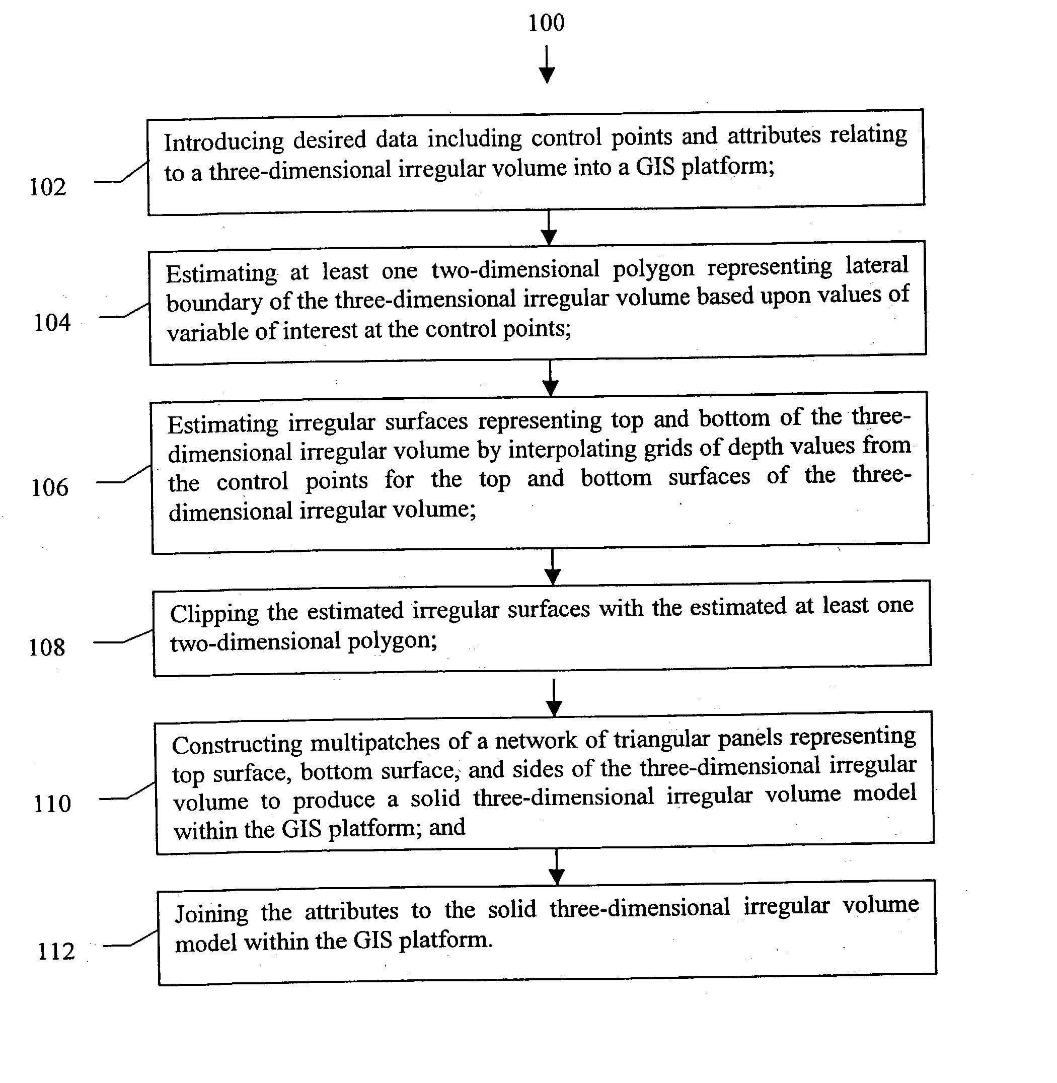
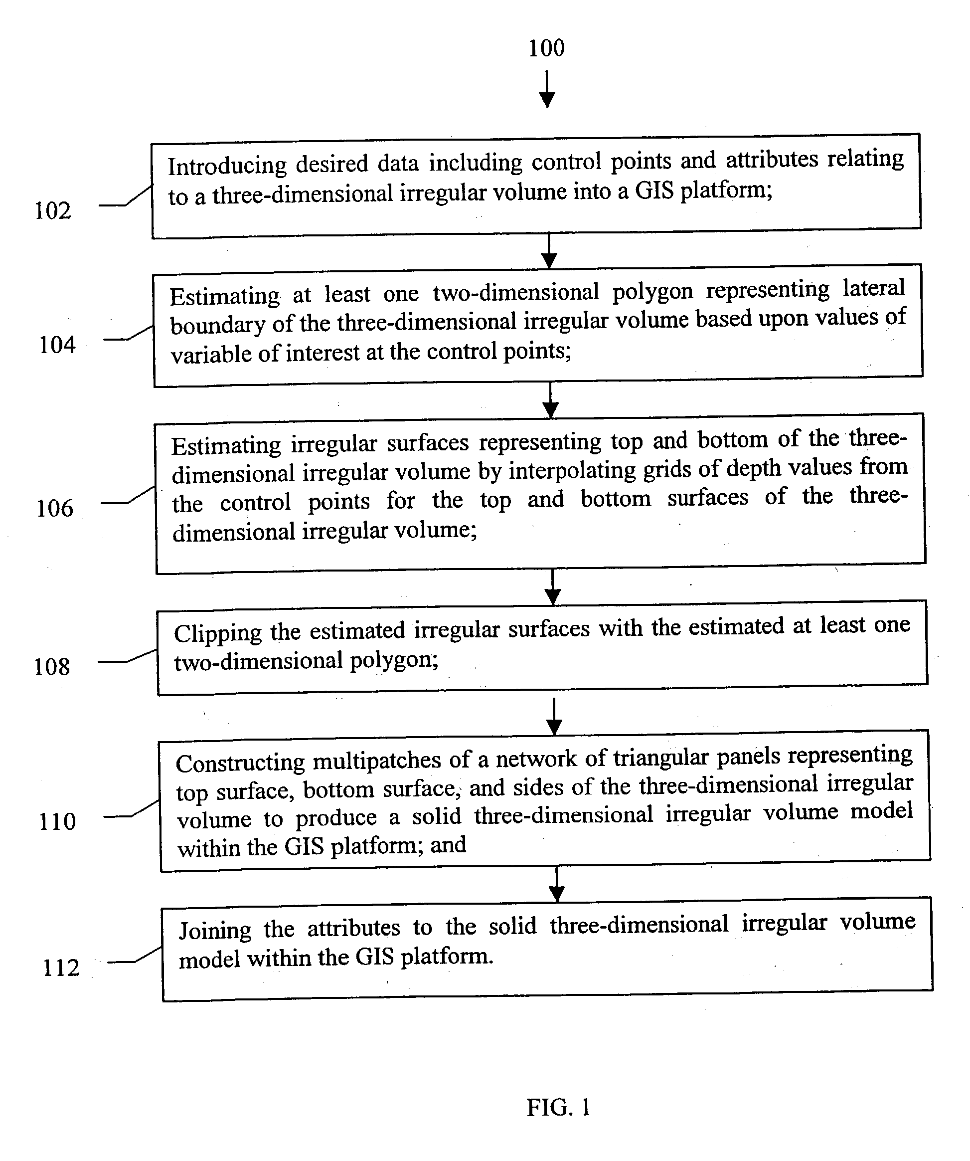
[0073] Referring to FIG. 8, an exemplary preferred embodiment of the present invention is described specifically for the oil and gas field. In this example, the method 1000 of the present invention provides the functionality of GIS systems in three dimensions to geologists, geophysicists, engineers, managers in the oil and gas industry, and others that may desire such geological and engineering information. Specifically, the method 1000 provides users with three-dimensional models of specific oil and gas fields within a three-dimensional GIS system for analysis, visualization and data management. Referring to FIG. 8, the method 1000 is comprised of several steps:

[0074] 1. Data Collection

[0075] The method 1000 may include collecting data on the oil and gas reservoir that will be used in construction of the three-dimensional irregular polygonal model and data on the attributes of the reservoir that will be joined with the model in a GIS platform (1002). Reservoir location data is deri...


PUM


Abstract

A method to construct a solid three-dimensional polygonal model of a three-dimensional irregular volume within a GIS platform comprising of: (1) introducing desired data including control points and attributes relating to the three-dimensional irregular volume into the GIS platform; (2) estimating at least one two-dimensional polygon representing a lateral boundary of the three-dimensional irregular volume based upon values of variable of interest at the control points; (3) estimating irregular surfaces representing top and bottom of the three-dimensional irregular volume by interpolating grids of depth values from the control points for the top and bottom surfaces of the three-dimensional irregular volume; (4) clipping the estimated irregular surfaces with the estimated at least one two-dimensional boundary polygon; (5) constructing multipatches of a network of triangular panels representing top surface, bottom surface, and sides of the three-dimensional irregular volume to produce a solid three-dimensional irregular volume model within the GIS platform; and (6) joining the attributes to the solid three-dimensional irregular volume model within the GIS platform. A method to construct a wire-frame three-dimensional polygonal model of a three-dimensional irregular volume within a GIS platform comprising of the same steps 1-4 and 6 as described above and the step of constructing a grid of regularly spaced polylineZs representing top surface, bottom surface, and sides of the three-dimensional irregular volume to produce the wire frame three-dimensional irregular volume model within the GIS platform. A system comprising of a computer system and processing software using the method of the present invention to construct a three-dimensional polygonal model of a three-dimensional irregular volume within a GIS platform.

Description

CLAIM OF BENEFIT OF FILING DATE[0001] The present application claims the benefit of the filing date of U.S. Provisional Application Serial No. 60 / 342,018 entitled "A Process and Apparatus for Creating Irregular Three-Dimensional Polygonal Models of Oil and Gas Reservoirs in a Three-Dimensional Geographic Information System", filed on Dec. 19, 2001 and hereby incorporated by reference in its entirety.[0002] This invention relates generally to the representation of irregular three-dimensional bodies and fields in a three-dimensional geographic information system. More specifically, this invention provides a method and a system for creating irregular three-dimensional polygonal models of oil and gas reservoir bodies or other three-dimensional volumes within a three-dimensional geographic information system.BACKGROUND OF INVENTION[0003] Geographic information systems (GIS) are used in a very wide variety of applications in industries such as urban planning, agriculture, defense, utiliti...

Claims


Application Information

Patent Timeline
IPC IPC(8): G06T17/20G09B29/00G09B29/10G09B29/12
CPCG06T17/20G09B29/12G09B29/106G09B29/006
Inventor GRACE, JOHN D.
Owner EARTH SCI ASSOCS
Learn More