
Intelligent management system integrating satallite locating technique, geographical information technique and mobile communication technique

A technology of geographic information technology and intelligent management system, which is applied in traffic control system, traffic control system of road vehicles, instruments, etc., to achieve the effect of timely scheduling and eliminating unsafe factors

Inactive Publication Date: 2002-12-04
SHANGHAI YAO WEI GROUP IND
View PDF0 Cites 96 Cited by
  • Summary
  • Abstract
  • Description
  • Claims
  • Application Information

AI Technical Summary

Problems solved by technology

[0002] At present, the management systems using satellite positioning technology (GPS) in China are mainly in the fields of public security and finance. There is still no management system that is completely suitable for the public transportation industry, and there is no combination of GPS, GIS and GSM technologies. , a management system integrating automatic station announcement, multi-screen linkage display, alarm, navigation and information service

Method used


Image

  • Intelligent management system integrating satallite locating technique, geographical information technique and mobile communication technique
  • Intelligent management system integrating satallite locating technique, geographical information technique and mobile communication technique
  • Intelligent management system integrating satallite locating technique, geographical information technique and mobile communication technique

Examples


Embodiment Construction

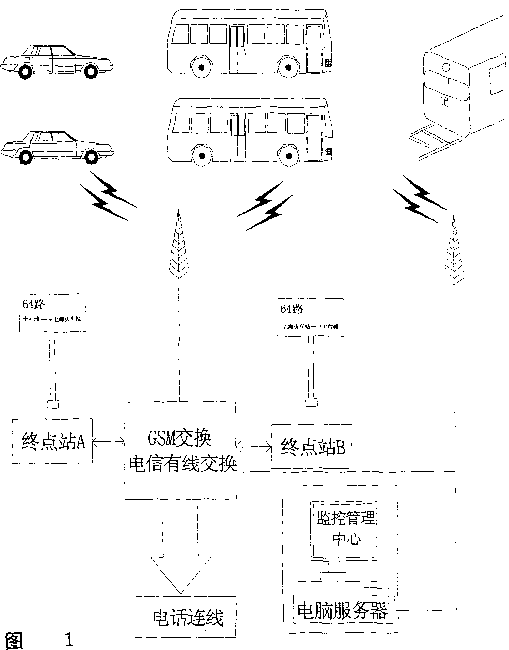
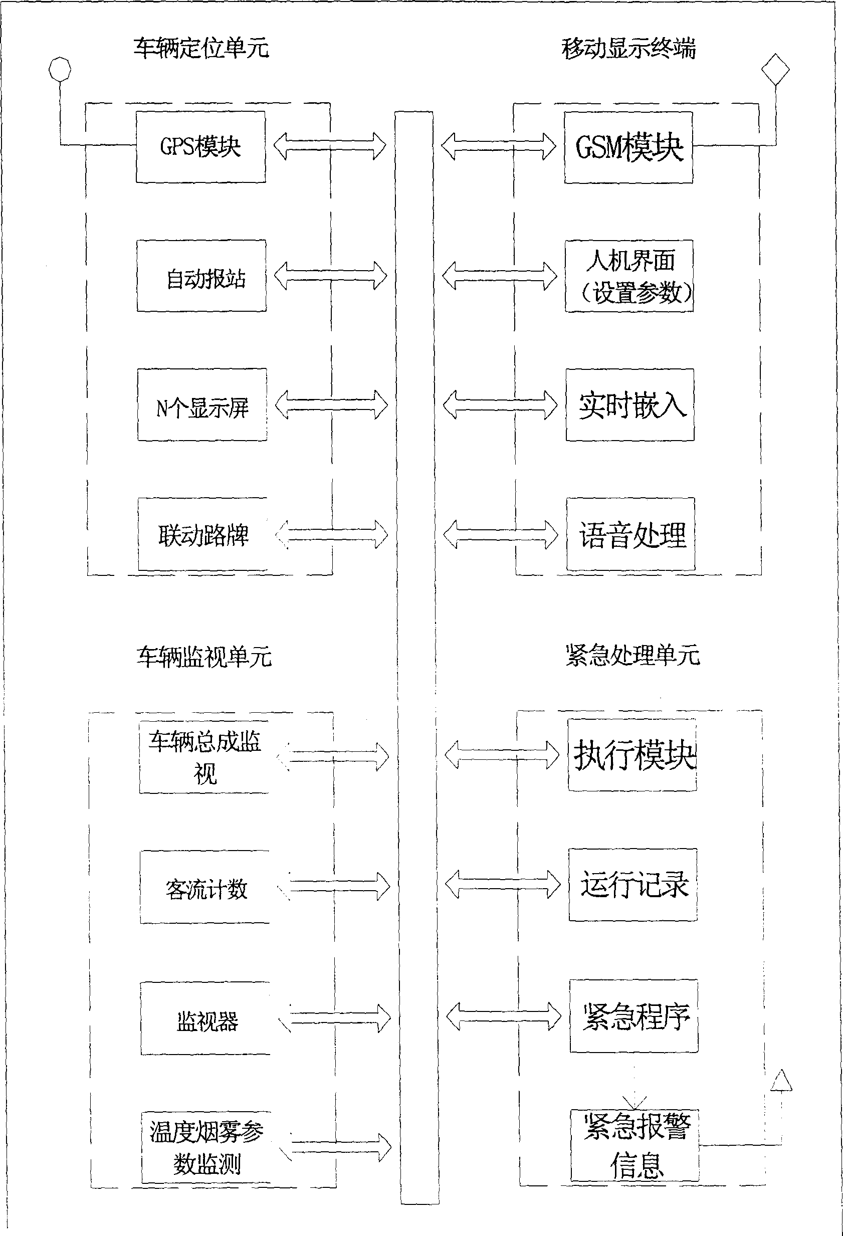
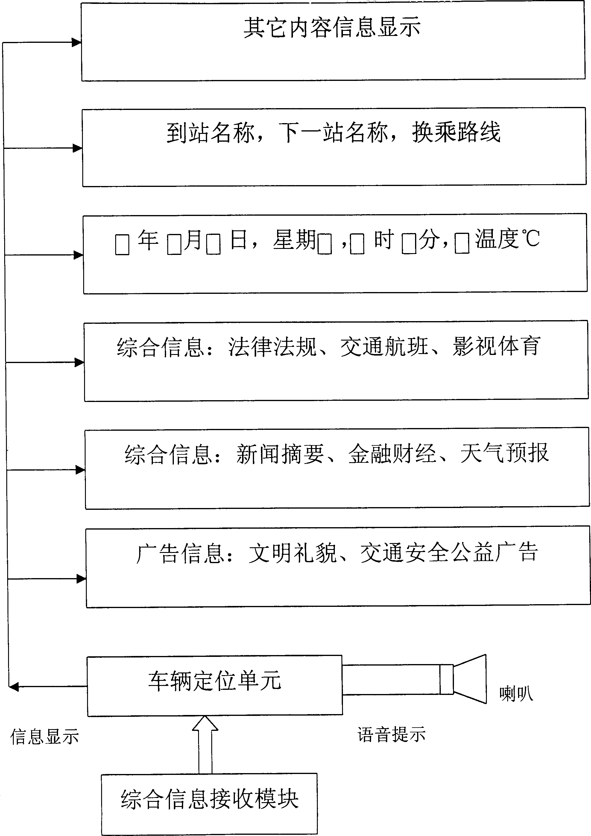
[0030] Please refer to accompanying drawing 1,2,3, vehicle-mounted intelligent control device, be provided with vehicle positioning unit, this unit comprises satellite receiving module (GPS), automatic station reporting module, N display screens and linkage road sign, the present invention adopts DGPS technology, That is, the differential global positioning system, the method is to install a monitoring receiver at a correct known position, calculate the distance error of each GPS satellite it can track, and send this number to the user receiver for error correction, thereby improving For positioning accuracy, see the attached Figure 8 As shown in the circuit diagram of the principle circuit diagram of the automatic station announcement of satellite positioning buses, DGPS receives the current position coordinates of the vehicle, compares the coordinates with the station coordinates preset in the circuit, and if they are the same, sends a signal to the voice station announcer c...


PUM


Abstract

The invention includes the car borne intelligent control device and the monitoring management system (center). The car borne intelligent control device consists of the vehicle location unit, the unitfor monitoring vehicles, the mobile display terminal and the emergence process unit. The monitoring manage system is composed of two paths digital mobile communication, two paths telephone lines and one computer server. The information in the vehicle location unit and the monitoring vehicles unit of the car borne intelligent control device is processed by the data processor of the control device.The processed information is displayed on the mobile display terminal and the station is reported automatically by using voice. Also the processed information is sent to the monitoring management center through digital mobile communication network.

Description

technical field [0001] The invention relates to an integrated intelligent communication monitoring and management system that uses satellite positioning technology (GPS), geographic information technology (GIS) and digital mobile communication technology (GSM) on public transport vehicles, referred to as 3G integrated intelligent monitoring and management system, which belongs to communication technology field. Background technique [0002] At present, the management systems using satellite positioning technology (GPS) in China are mainly in the fields of public security and finance. There is still no management system that is completely suitable for the public transportation industry, and there is no combination of GPS, GIS and GSM technologies. , a management system integrating automatic station announcement, multi-screen linkage display, alarm, navigation and information service. Contents of the invention [0003]...

Claims


Application Information

Patent Timeline
IPC IPC(8): G08G1/123
Inventor 姚薇
Owner SHANGHAI YAO WEI GROUP IND
Learn More