A Big Data Analysis Method of Farmland Area Based on Satellite Remote Sensing Image

A satellite remote sensing image and analysis method technology, which is applied in the field of big data analysis, can solve problems that affect the effect of data analysis or inability to experience intuitively, user data map services, etc.

Active Publication Date: 2022-04-26
北京航天丰益信息技术有限公司
View PDF6 Cites 0 Cited by
  • Summary
  • Abstract
  • Description
  • Claims
  • Application Information

AI Technical Summary

Problems solved by technology

[0006] At present, the commonly used technologies in GIS are overlay analysis and Mercator projection technology. Each technical method has its own unique advantages, but at the same time there are many defects, which often affect the data analysis effect or intuitive experience. Unable to bring a full range of data map services to users

Method used


Image

  • A Big Data Analysis Method of Farmland Area Based on Satellite Remote Sensing Image
  • A Big Data Analysis Method of Farmland Area Based on Satellite Remote Sensing Image
  • A Big Data Analysis Method of Farmland Area Based on Satellite Remote Sensing Image

Examples


Embodiment Construction

[0046] In order to make the purpose, technical solutions and advantages of the embodiments of the present invention clearer, the technical solutions in the embodiments of the present invention will be clearly described below in conjunction with the accompanying drawings in the embodiments of the present invention. Obviously, the described embodiments are the Some, but not all, embodiments are invented. Based on the embodiments of the present invention, all other embodiments obtained by persons of ordinary skill in the art without making creative efforts belong to the protection scope of the present invention.

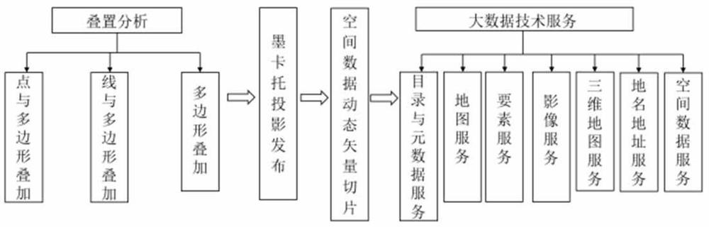
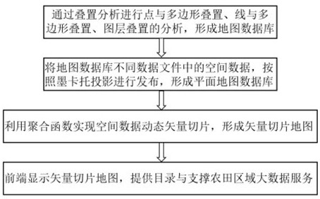
[0047] The invention integrates heterogeneous map data through a unified data model, unifies the coding modes of different map data, and unifies the spatial reference system. When integrating heterogeneous map data, the analysis of point and polygon overlay, line and polygon overlay, and polygon overlay is performed through overlay analysis. When using satellite remote s...


PUM


Abstract

The present invention proposes a large data analysis method for farmland areas based on satellite remote sensing images, which analyzes point and polygon overlay, line and polygon overlay, and layer overlay analysis through overlay analysis to form a map database; The spatial data in the data files, including point layer files, line layer files, and surface layer files, are released uniformly according to the Mercator projection to form a planar map database; the aggregation function is used to realize dynamic vector slicing of spatial data, and the planar map database Data information is encoded into vector slices, saved as vector block data of various scales, forming a vector slice map; the front end displays the vector slice map, and provides catalog and metadata services, map services, feature services, image services, and 3D maps Service, place name address service and spatial data service to support the application of big data in farmland areas.

Description

technical field [0001] The invention relates to the technical field of big data analysis, in particular to a method for analyzing big data in farmland areas based on satellite remote sensing images. Background technique [0002] In the prior art, the monitoring of the growth of farmland areas mainly adopts the method of manual survey, which is also the most commonly used method in agricultural production at present. This method is easy to operate, simple and effective, but requires a lot of manpower, the observation area is small, and the efficiency is low. At the same time, the personnel who use this method also need to have rich production experience and agricultural knowledge, which is highly subjective and not suitable for large-scale farmland monitoring. [0003] Since crops have strong absorption in the visible light band and obvious reflection in the near-infrared band, satellite remote sensing technology can monitor crop growth based on different crop types or diffe...

Claims


Application Information

Patent Timeline
Patent Type & Authority Patents(China)
IPC IPC(8): G06V20/10G06T17/05G06F16/29
CPCG06F16/29G06T17/05
Inventor 常晓燕
Owner 北京航天丰益信息技术有限公司
Why Eureka
Try Eureka