
Method and system for generating 3D scene through two-dimensional GIS vector data

A vector data and 3D technology, applied in the field of 2D GIS vector data to generate 3D scenes, can solve the problems of low efficiency, inconvenience of fast and intuitive presentation of data, and high cost of 3D data production

Pending Publication Date: 2022-01-21
GUANGZHOU FRONTOP DIGITAL ORIGINALITY TECH CO LTD
View PDF0 Cites 0 Cited by
  • Summary
  • Abstract
  • Description
  • Claims
  • Application Information

AI Technical Summary

Problems solved by technology

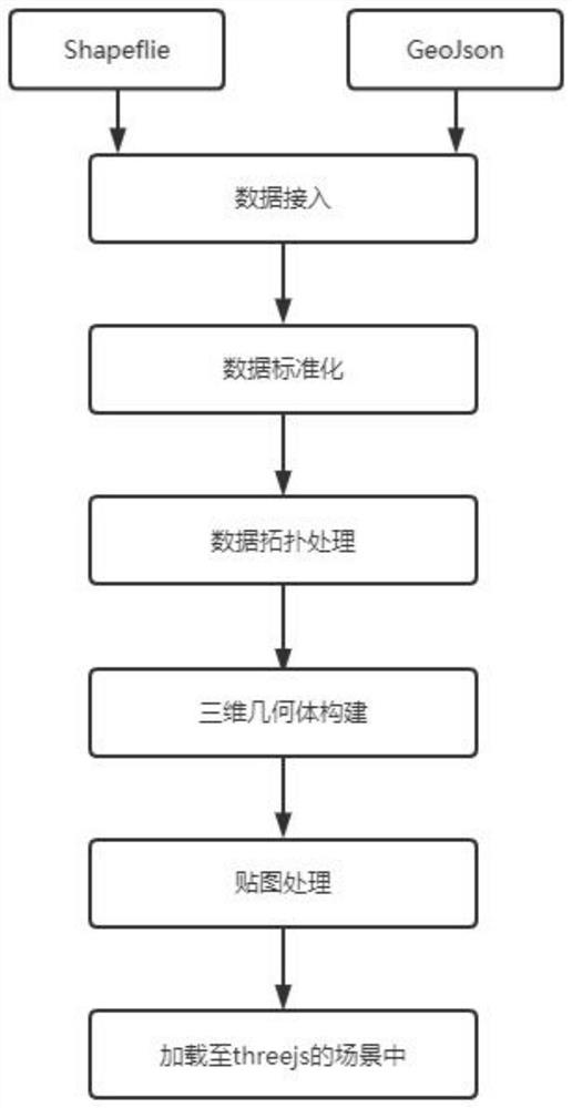
[0003] In view of the defects existing in the prior art, the purpose of the present invention is to provide a method and system for generating 3D scenes from two-dimensional GIS vector data, which solves the problem that most of the current three-dimensional scene modeling relies on manual modeling methods, and modeling through 3DSMax, etc. Software modeling, 3D data production costs are high, update and maintenance also need to be carried out by professional modeling personnel, the efficiency is low and it is not convenient for the fast and intuitive presentation of data

Method used


Image

  • Method and system for generating 3D scene through two-dimensional GIS vector data
  • Method and system for generating 3D scene through two-dimensional GIS vector data
  • Method and system for generating 3D scene through two-dimensional GIS vector data

Examples


Embodiment Construction

[0035] The following will clearly and completely describe the technical solutions in the embodiments of the present invention with reference to the accompanying drawings in the embodiments of the present invention. Obviously, the described embodiments are only some of the embodiments of the present invention, not all of them. Based on the embodiments of the present invention, other embodiments obtained by persons of ordinary skill in the art without making creative efforts all belong to the protection scope of the present invention.

[0036] English name of the present invention is explained below:

[0037] Shapefile, an open standard spatial data open format in the geographic information software industry.

[0038] GeoJson, a format for encoding various geographic data structures, is a geospatial information data exchange format based on JavaScript Object Notation (JSON for short).

[0039] GeoTools: An open source Java GIS toolkit.

[0040] Three.js: A webGL framework.

...


PUM


Abstract

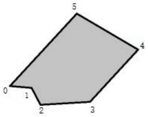
The invention provides a method and system for generating a 3D scene through two-dimensional GIS vector data. The method specifically comprises the following steps: enabling a client to upload the two-dimensional GIS vector data of a building surface to a server; enabling the server to receive the data and performs format standardization operation on the data; performing topological processing on the standardized building surface data, and converting complex polygons in the building surface into simple polygons; reading a vertex array of the simple polygon, and constructing the building surface into a three-dimensional geometry; if the attribute value of the map type exists in the building surface data, acquiring a corresponding map to execute a tiling operation, otherwise, reading a default map to execute the tiling operation; and forming a grid object by combining the three-dimensional geometry and the material after the paving operation, and adding the grid object into the 3D scene. The two-dimensional GIS vector data of the building surfaces are obtained, and the two-dimensional GIS vector data are automatically pulled up and mapped according to the height information of the data of each building surface and then added into the three-dimensional scene, so that the problem of low efficiency caused by manual contrast of CAD drawing data or manual modeling is solved.

Description

technical field [0001] The invention relates to three-dimensional modeling technology, in particular to a method and system for generating 3D scenes from two-dimensional GIS vector data. Background technique [0002] With the development of technology, the traditional two-dimensional GIS map display method can no longer meet the needs of users for visual experience. The 3D GIS scene allows people to browse map data with a 720-degree view, which greatly improves the user experience. However, at present, most of the 3D scene modeling relies on manual modeling, and modeling is carried out through modeling software such as 3DSMax. The production cost of 3D data is relatively high, and the update and maintenance also need to be carried out by professional modeling personnel, which is inefficient and inconvenient. Fast visual presentation of data. Contents of the invention [0003] In view of the defects in the prior art, the purpose of the present invention is to provide a me...

Claims


Application Information

Patent Timeline
IPC IPC(8): G06T17/10G06T15/04G06T19/20
CPCG06T17/10G06T15/04G06T19/20G06T2210/04G06T2219/2021
Inventor 谢君亮谢家豪欧阳志远
Owner GUANGZHOU FRONTOP DIGITAL ORIGINALITY TECH CO LTD
Learn More