
Tile map service method

A tile map and service method technology, applied in geographic information databases, structured data retrieval, instruments, etc., can solve problems such as security risks, unauthorized application data leakage of tile maps, etc., to achieve flexible processes and solve unauthorized applications. and data leakage, the effect of improving data security

Pending Publication Date: 2021-12-21
成都市规划和自然资源信息中心
View PDF3 Cites 1 Cited by
  • Summary
  • Abstract
  • Description
  • Claims
  • Application Information

AI Technical Summary

Problems solved by technology

[0003] The purpose of the present invention is to solve the security risks such as unauthorized applications and data leakage in the existing tile map technology, and propose a tile map service method

Method used


Image

  • Tile map service method
  • Tile map service method
  • Tile map service method

Examples


Embodiment Construction

[0035] Embodiments of the present invention will be further described below in conjunction with the accompanying drawings.

[0036] Before describing the specific embodiments of the present invention, in order to make the scheme of the present invention more clear and complete, at first the abbreviations and key term definitions that appear in the present invention are explained:

[0037] Tile map service request: When using the map service, the user sends an Http request to the map server to obtain pictures of a certain range at a specific scale.

[0038] Spatial overlay method: It is a well-known method in the field, mainly used for comprehensive analysis of multiple thematic layers, and is a traditional spatial analysis method determined by the regional and multi-level characteristics of GIS.

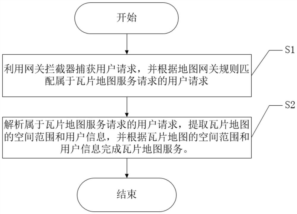
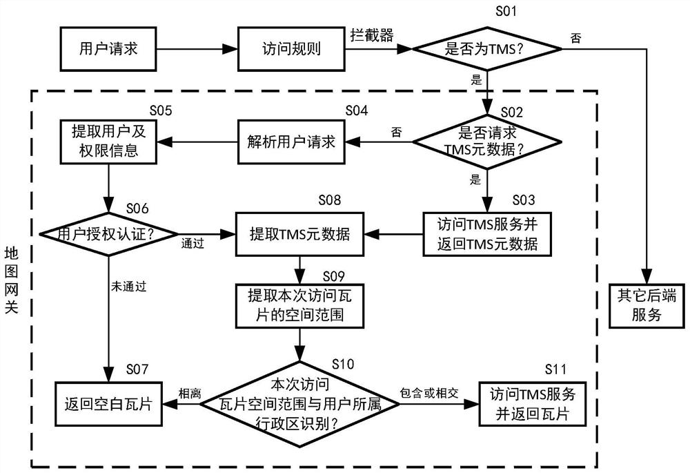
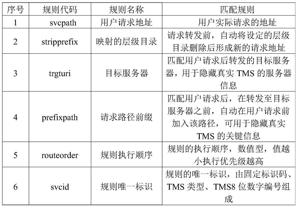
[0039] Such as figure 1 As shown, the present invention provides a tile map service method, comprising the following steps:

[0040] S1: Use the gateway interceptor to capture user...


PUM


Abstract

The invention discloses a tile map service method. The method comprises the following steps: S1, capturing a user request by using a gateway interceptor, and matching the user request belonging to a tile map service request according to a map gateway rule; S2, analyzing the user request belonging to the tile map service request, extracting a spatial range and user information of a tile map, and completing tile map service according to the spatial range and user information of the tile map. According to a tile map service gateway method based on regional application and user authorization, authorized access of the tile map service is achieved on the premise that the existing tile map service is not changed, and therefore, the tile map service gateway method is flexible in process and good in compatibility and portability; in combination with a gateway technology, information of a rear-end map server is shielded, so that data security is improved, and potential safety hazards such as unauthorized application and data leakage of tile map services are solved.

Description

technical field [0001] The invention belongs to the technical field of tile maps, and in particular relates to a tile map service method. Background technique [0002] Tile map service refers to the tile map service specification in accordance with the Open Source Geospatial Foundation (Open Source Geospatial Foundation, a global non-profit organization whose goal is to support global cooperation, establish and promote high-quality spatial information open source software) , providing users with a standard on-demand access map service, which makes the front-end access faster, the back-end server consumes less, and the user experience is better. In the existing tile map service, all users can use the global map, which leads to security risks such as unauthorized application of information and data leakage. At present, there are two commonly used solutions. One is to release tile map services separately by region, and the other is to transform the existing technology implemen...

Claims


Application Information

Patent Timeline
Patent Type & Authority Applications(China)
IPC IPC(8): G06F16/29G06F16/909H04L12/66
CPCG06F16/29H04L12/66G06F16/909
Inventor 方从刚张虎窦义红杨盛强赵朋刘光辉成思源童亮马瑞陈翀张创张其海吕杨陈言军黄一睿
Owner 成都市规划和自然资源信息中心
Learn More