
A high-precision map production method for unmanned driving scenarios in mines

An unmanned driving and production method technology, which is applied in image analysis, image enhancement, image data processing and other directions, can solve the problem of difficulty in judging the location of mine roads, the difficulty of updating the frequency of high-precision maps to meet the actual needs of mining scenes, and the production method of high-precision maps. It is difficult to apply to problems such as mine roads and achieve high accuracy and robustness.

Active Publication Date: 2022-06-14
安徽海博智能科技有限责任公司
View PDF10 Cites 0 Cited by
  • Summary
  • Abstract
  • Description
  • Claims
  • Application Information

AI Technical Summary

Problems solved by technology

Unlike highways, the geographical conditions of open-pit mining areas are always in the process of updating and changing, and the update frequency of existing high-precision maps is difficult to meet the actual needs of mining areas.
High-precision map making methods are difficult to apply to mine roads without road signs
There are no obvious lane lines, signs, and roadside poles on the roads in open-pit mining areas, especially in severe weather conditions such as rain, snow and fog, it is difficult to judge the location of mine roads

Method used


Image

  • A high-precision map production method for unmanned driving scenarios in mines

Examples


Embodiment approach

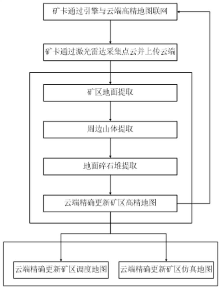
[0029] The specific embodiment uses the vehicle-mounted high-precision map engine provided on the unmanned mining card to retrieve the high-precision map in the cloud in the network, and the engine retrieves the high-precision map elements through ID retrieval or spatial location retrieval. At the same time, all the elements of the high-precision map within the corresponding range are extracted as backup data for the automatic driving module of the unmanned mining cart.

[0030] S2. Use lidar to collect the original point cloud data of the mining area in real time, and upload it to the cloud server;

[0031] The specific embodiment uses a professional map data collection vehicle, where an unmanned mine card equipped with a laser radar can be used to collect the environmental information of the mining area, collect the original point cloud data required for mapping, and at the same time convert the original point cloud data Upload to cloud server. Through this design, elements...


PUM


Abstract

The invention discloses a high-precision map production method for unmanned driving scenes in mines. The specific steps include retrieving cloud high-precision maps through a vehicle-mounted high-precision map engine, and extracting high-precision map elements within a corresponding range; Collect the original point cloud data of the mining area and upload it to the cloud server; segment and extract the map elements in the original point cloud data according to the original point cloud data, and assign semantic information for storage; update the high-precision cloud map to the simulation map and schedule in real time map. The present invention collects the point cloud data of the mining area scene by laser radar, and performs element segmentation and extraction. And further confirm the map elements. At the same time, the high-precision map information is updated to the dispatch map and simulation map in real time. In this way, the linkage effect of the three maps is realized. It can be applied to extract road elements such as the mine ground, surrounding mountains, and gravel piles in complex open-pit mine environments for identification, and has high accuracy and robustness.

Description

technical field [0001] The invention relates to the technical field of automatic driving map making, in particular to a high-precision map making method for unmanned driving scenes in mines. Background technique [0002] At present, most of the high-precision map production methods are oriented to urban roads and rely on professional map collection vehicles for point cloud data collection. Different from expressways, the geography of open-pit mines has been in the process of updating and changing, and the update frequency of existing high-precision maps is difficult to meet the actual needs of mining scenes. The high-precision map production method is difficult to apply to mine roads without road signs. There are no obvious lane lines, signs and roadside poles and other signs on the roads in the open-pit mining area, especially in severe weather conditions such as rain, snow and fog, it is difficult to determine the location of the mine road. SUMMARY OF THE INVENTION [...

Claims


Application Information

Patent Timeline
Patent Type & Authority Patents(China)
IPC IPC(8): G06T17/05G06T15/20G06T7/13
CPCG06T17/05G06T15/205G06T7/13G06T2207/10028
Inventor 秦晓驹潘伟陈成张帅乾程坤鹏
Owner 安徽海博智能科技有限责任公司
Learn More