
Leveling data processing system and method in hydraulic engineering measurement

A water conservancy project and data processing technology, applied in the direction of complex mathematical operations, can solve problems such as low work efficiency, slow speed of laying horizontal lines, and high labor intensity, so as to avoid rework, improve laying speed and work efficiency, and reduce labor intensity and cost effects

Pending Publication Date: 2021-10-22
河南省水利勘测设计研究有限公司
View PDF0 Cites 0 Cited by
  • Summary
  • Abstract
  • Description
  • Claims
  • Application Information

AI Technical Summary

Problems solved by technology

In the survey of water conservancy projects, leveling lines need to be laid out before drone aerial photography, which requires that the surveying and mapping site need to quickly realize the leveling line layout. At present, field personnel generally use high-precision digital levels for surveying. From this instrument The format of the uploaded and downloaded field measurement data is not easy to read and does not conform to the data archiving format, and after the field personnel record the on-site observation data, they need to return to the room to perform adjustment calculation and accuracy evaluation on the observation data, and then obtain the leveling line results. Then lay the leveling line on the return site
In this process, errors in leveling observation data cannot be found in time, and it is easy to cause rework, resulting in low work efficiency, high labor intensity, and slow laying of leveling lines, which cannot match the efficiency of UAV aerial photography technology.

Method used


Image

  • Leveling data processing system and method in hydraulic engineering measurement
  • Leveling data processing system and method in hydraulic engineering measurement
  • Leveling data processing system and method in hydraulic engineering measurement

Examples


Embodiment Construction

[0047] The technical solutions in the embodiments of the present invention will be clearly and completely described below, obviously, the described embodiments are only some of the embodiments of the present invention, not all of the embodiments. Based on the embodiments of the present invention, all other embodiments obtained by persons of ordinary skill in the art without creative efforts fall within the protection scope of the present invention.

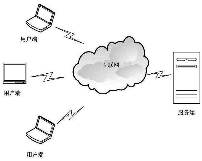
[0048] Such as figure 1 As shown, the level data processing system in the water conservancy engineering survey of the present invention is composed of a server and a plurality of clients; Feedback to the client; the client can be any device that can access the Internet such as a mobile phone, a mobile computer, a fixed computer, and has data input capabilities; field workers can import level data into a remote server through the client, Automatically calculate, summarize and generate intermediate calculation reports and elevation...


PUM


Abstract

The invention discloses a leveling data processing system and method in hydraulic engineering measurement. The leveling data processing system is composed of a server side and a plurality of user sides, wherein the server side is used for performing data processing on leveling data uploaded by the user sides and feeding back data processing results to the user sides in real time; the user sides are used for leading the leveling data into the remote server side by field staff; and the server side automatically calculates, summarizes and generates an intermediate calculation report and an elevation route map, so that the field staff can obtain adjustment results, precision evaluation results and leveling results in time, and automatic calculation and automatic summarization of the leveling results are realized. The system and the method have the advantages that the field staff import measurement data into the remote server through the user sides, and the field staff can obtain the adjustment results, the precision evaluation results and the leveling results in time through automatic processing, storage and real-time feedback of the field measurement data through the server side, so that the situation that the field staff return indoors to rearrange the leveling data and store the leveling results is avoided.

Description

technical field [0001] The invention relates to the field measurement field in water conservancy engineering, in particular to a level data processing system and method in water conservancy engineering measurement. Background technique [0002] In order to improve my country's surveying and mapping technology and equipment, the National Bureau of Surveying, Mapping and Geographic Information is focusing on the promotion and application of UAV aerial photography technology. The application of UAV aerial photography technology has played an active role in building digital water conservancy, detecting geographical conditions, and improving water conservancy management efficiency. In water conservancy engineering surveying, leveling lines need to be laid out before drone aerial photography, which requires that the surveying and mapping site need to quickly realize the leveling line layout. At present, field personnel generally use high-precision digital levels for surveying. Fro...

Claims


Application Information

Patent Timeline
Patent Type & Authority Applications(China)
IPC IPC(8): G06F17/10
CPCG06F17/10
Inventor 聂宗斋李朝辉吴松韩光张增印荣立孙会超郭超陈冲彭刚跃苏帅伟孙汝辉任鼎鑫刘思慧赵贵清胡振邦王梦樱王展李思敏王雅琳
Owner 河南省水利勘测设计研究有限公司
Learn More