Technology for engineering positioning and monitoring based on satellite navigation high-precision positioning and lora communication

A satellite navigation and high-precision technology, applied in satellite radio beacon positioning system, measuring device, radio wave measuring system, etc., can solve the problems of small number of sensors, high construction difficulty, and inconvenient networking

Inactive Publication Date: 2021-09-07
深圳市慧达工程科技有限公司
View PDF0 Cites 0 Cited by
  • Summary
  • Abstract
  • Description
  • Claims
  • Application Information

AI Technical Summary

Problems solved by technology

[0003] 1. Generally does not support wireless networking, only supports single-point transmission to the cloud, and the networking between field devices is inconvenient
Most traditional systems use on-site wiring and routers to set up a cable network, which is complex and difficult to construct in scenarios such as bridges in the wild;
[0004] 2. The number of sensors supported by field devices is small, and traditional devices are limited by the number of serial ports;
[0005] 3. Does not support low power consumption, generally requires mains power supply;
[0006] 4. Monitoring is inconvenient. The traditional early warning system requires a special monitoring room, which is monitored by a special person in front of the computer.
[0007] Traditional monitoring systems generally do not support satellite high-precision positioning. Displacement monitoring generally uses traditional methods such as resistance rod sensors, which are difficult to use in some application scenarios such as bridges and high-rise buildings. Therefore, we propose a high-precision positioning based on satellite navigation and The lora communication technology used for engineering positioning monitoring is used to solve the above problems

Method used


Image

  • Technology for engineering positioning and monitoring based on satellite navigation high-precision positioning and lora communication
  • Technology for engineering positioning and monitoring based on satellite navigation high-precision positioning and lora communication
  • Technology for engineering positioning and monitoring based on satellite navigation high-precision positioning and lora communication

Examples


Embodiment Construction

[0034] The following will clearly and completely describe the technical solutions in the embodiments of the present invention with reference to the accompanying drawings in the embodiments of the present invention. Obviously, the described embodiments are only some, not all, embodiments of the present invention.

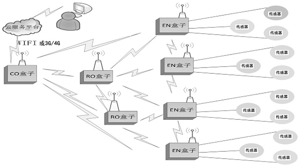
[0035] refer to Figure 1-4 , a technology based on satellite navigation high-precision positioning and lora communication for engineering positioning monitoring. The engineering positioning monitoring system consists of various sensors, terminal control box (EN box), transfer box (RO box), central communication box (CO Box), mobile communication network (China Mobile or China Unicom), cloud service cluster, management personnel terminal computer, etc.:

[0036] 1) Central communication box CO box:

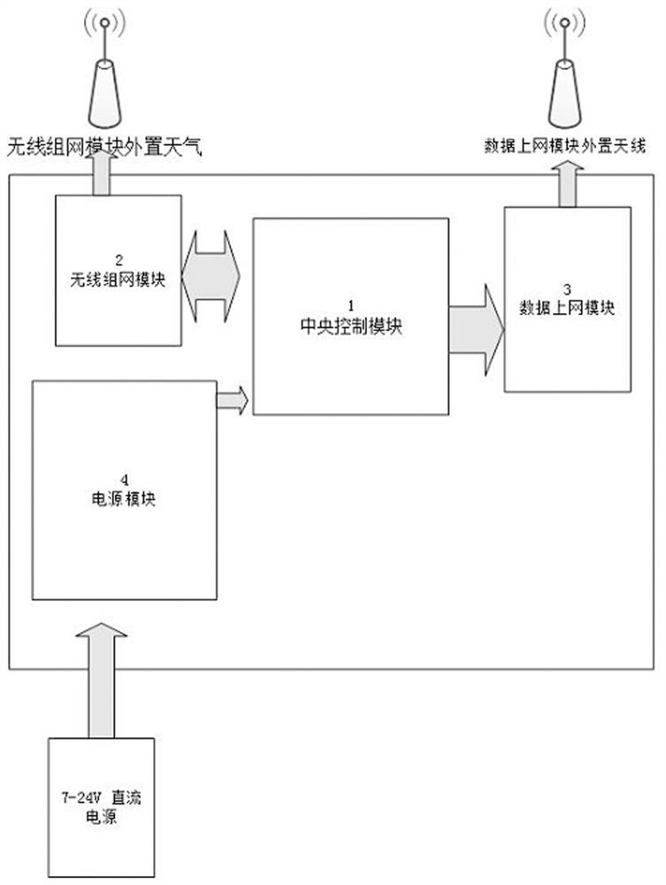
[0037] as attached figure 2 , the central communication box CO box includes a central control module 1, a wireless networking module 2, a data access module 3, and a ...


PUM


Abstract

The invention belongs to the technical field of engineering monitoring, and particularly relates to a technology for engineering positioning and monitoring based on satellite navigation high-precision positioning and lora communication. An engineering positioning and monitoring system comprises a central communication box (CO box), wherein the CO box comprises a central control module, a wireless networking module, a data internet access module and a power supply module; a terminal control box (EN box), wherein the EN box comprises a central control module, a wireless networking module, a power supply module and three sensor data communication modules; a transfer box (RO box), wherein the RO box comprises a central control module, a wireless networking module and a power supply module 13; and a cloud service platform which is used for receiving, processing, analyzing and calculating all the uploaded data, carrying out data statistics and providing background data service. According to the design of the invention, a high-precision satellite positioning technology and a Lora wireless networking technology applied to an unmanned aerial vehicle are originally integrated and introduced into the field of engineering monitoring, and long-distance free networking, high-precision real-time data acquisition and cloud uploading are realized.

Description

technical field [0001] The invention relates to the technical field of engineering monitoring, in particular to a technology for engineering positioning monitoring based on satellite navigation high-precision positioning and lora communication. Background technique [0002] The current engineering monitoring system: [0003] 1. Generally, it does not support wireless networking, and only supports single-point transmission to the cloud, which is inconvenient for networking between field devices. Most traditional systems use on-site wiring and routers to set up a cable network, which is complex and difficult to construct in scenarios such as bridges in the wild; [0004] 2. The number of sensors supported by field devices is small, and traditional devices are limited by the number of serial ports; [0005] 3. Does not support low power consumption, generally requires mains power supply; [0006] 4. Monitoring is inconvenient. The traditional early warning system requires a ...

Claims


Application Information

Patent Timeline
IPC IPC(8): G01S19/41H04L29/08
CPCG01S19/41H04L67/06H04L67/10
Inventor 梁敬平梁宏刚
Owner 深圳市慧达工程科技有限公司
Why Eureka
Try Eureka