Method for realizing elevation measurement by using gravity, GNSS-RTK and gravity field model

A gravity field model and elevation measurement technology, which is applied in height/horizontal measurement, measuring devices, surveying and navigation, etc., can solve the problems of abnormal elevation accuracy, poor practicability, time-consuming and labor-intensive, etc., and achieve high measurement accuracy, simple steps, The effect of improving accuracy

Active Publication Date: 2021-06-18
雷军珍
View PDF6 Cites 1 Cited by
  • Summary
  • Abstract
  • Description
  • Claims
  • Application Information

AI Technical Summary

Problems solved by technology

This method has the following shortcomings: different gravity field models lead to different accuracy of calculated elevation anomalies, and the accuracy of gravity field models can only obtain elevation anomalies at the centimeter level to decimeter level; the accuracy of elevation anomalies calculated in different regions is not the same. The accuracy of the area is high, and the accuracy of the mountain area is poor; the distance between adjacent points must be long enough (greater than 5km or even longer) in order to meet the accuracy requirements of the third and fourth-class leveling surveys. For engineering surveys, the distance between adjacent points Often only a few hundred meters, so less practical
This method is time-consuming, labor-intensive, and has low precision

Method used


Image

  • Method for realizing elevation measurement by using gravity, GNSS-RTK and gravity field model

Examples


Embodiment Construction

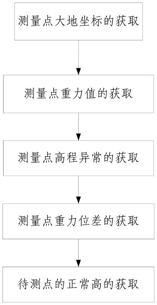
[0070] Such as figure 1 A method of height measurement using gravity, GNSS-RTK and gravity field model is shown, including the following steps:

[0071] Step 1. Obtaining the geodetic coordinates of the measuring point:

[0072] Step 101, lay out the starting point A and the point B to be measured in the area to be measured, and obtain the normal height H of the starting point A A ;

[0073] Step 102, setting e transition points between the starting point A and the point B to be measured; wherein, the e transition points are located along the line between the starting point A and the point B to be measured, and e is a natural number;

[0074] Step 103, mark the starting point A, multiple transition points and the point B to be measured, and the direction from the starting point A to the point B to be measured in sequence as the first measurement point, ..., the i-th measurement point, .. ., the n'th measurement point; where, i and n' are both positive integers, 1≤i≤n';

[00...


PUM


Abstract

The invention discloses a method for realizing elevation measurement by utilizing gravity, GNSS-RTK and a gravity field model. The method comprises the following steps of: 1, acquiring geodetic coordinates of a measurement point; 2, obtaining a gravity value of the measurement point; 3, acquiring elevation anomaly of the measurement point; 4, obtaining the gravitational potential difference of the measurement point; and 5, obtaining the normal height of a point to be measured. The method is simple in step and reasonable in design, the geodetic height of the measurement points is obtained through the GNSS-RTK measurement technology, the gravity potential difference between the measurement points is obtained through flowing gravity observation, the height anomaly of the measurement points is calculated through the gravity field model, and finally the normal height of the point to be measured is calculated, so that high-precision height measurement is achieved.

Description

technical field [0001] The invention belongs to the technical field of engineering measurement, in particular to a method for realizing height measurement by using gravity, GNSS-RTK and a gravity field model. Background technique [0002] The measurement of normal height and height difference has always been a basic task in the field of surveying. Normal height plays an irreplaceable role in engineering construction and even in daily economic life. So far, the most precise method for measuring normal height is still leveling. The leveling method uses a leveling instrument to observe the front and rear leveling rods, take readings, and obtain the height difference of the station, and then accumulate the height differences measured one by one to obtain the height difference of the two control points. The error of leveling measurement can be less than ±0.1mm / km. This method not only increases the error sharply with the increase of the route length, but also consumes time and e...

Claims


Application Information

Patent Timeline
IPC IPC(8): G01C5/00
CPCG01C5/00
Inventor 段虎荣
Owner 雷军珍
Why Eureka
Try Eureka