
Spaceborne radar altimeter system and method

A technology of radar altimeter and spaceborne radar, which is applied in the direction of radio wave measurement system, instrument, measuring device, etc. It can solve the problems of increasing the development cost of spaceborne radar system, the difficulty of satellite system design, increasing the power consumption and weight of the whole star, etc.

Active Publication Date: 2021-05-14
SHANGHAI SATELLITE ENG INST
View PDF14 Cites 2 Cited by
  • Summary
  • Abstract
  • Description
  • Claims
  • Application Information

AI Technical Summary

Problems solved by technology

This will increase the development cost of the spaceborne radar system, and will also increase the power consumption and weight of the entire star, which will bring certain difficulties to the design of the satellite system

Method used


Image

  • Spaceborne radar altimeter system and method
  • Spaceborne radar altimeter system and method
  • Spaceborne radar altimeter system and method

Examples


Embodiment 1

[0057] Aiming at the defects in the prior art, the object of the present invention is to provide a two-in-one system of interferometric synthetic aperture radar altimeter and bottom-looking radar altimeter and its method based on signal coding, which can effectively simplify the hardware design of satellite system and reduce the difficulty of satellite development.

[0058] A kind of spaceborne radar altimeter method provided according to the present invention comprises:

[0059] Step M1: Set the coded signal pulse sequence as a periodic transmission sequence, and any pulses in the coded signal pulse sequence are in an orthogonal relationship;

[0060] Step M2: Set the pulse repetition frequency on the zebra chart. The set pulse repetition frequency controls the radar working sequence so that the nadir echo and the echo of the high area on the interference side can be received by the radar receiver at the same time, and the nadir echo and the interference side The echoes in th...

Embodiment 2

[0097] Embodiment 2 is a modification of embodiment 1

[0098] The present invention will be further described below in conjunction with the accompanying drawings.

[0099] Refer to attached figure 1 , the theoretical analysis basis of the present invention is briefly introduced as follows:

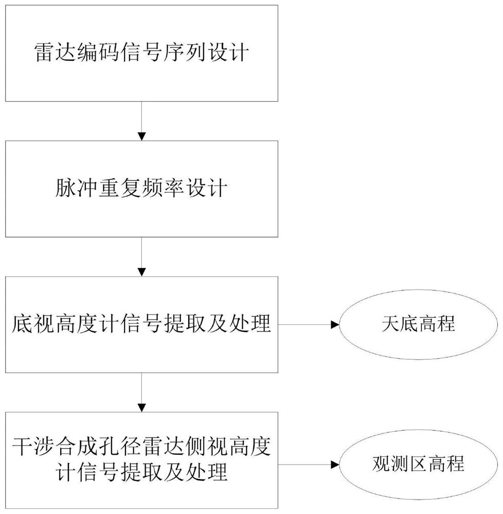
[0100] An interferometric synthetic aperture radar altimeter and bottom-looking radar altimeter two-in-one system and method based on signal coding, characterized in that it includes radar orthogonal coding signal sequence design, pulse repetition frequency design, bottom-looking altimeter signal extraction and processing and Interferometric radar altimeter signal extraction and processing. in:

[0101] 1) Radar coding signal sequence design

[0102] The coded signal pulse sequence is transmitted periodically, and any pulse in the pulse signal sequence is an orthogonal relationship, and its mathematical model is as follows;

[0103] the s k (t r )=s k+N (t r )

[0104]

[010...


PUM


Abstract

The invention provides a spaceborne radar altimeter method and system. The method comprises the following steps: setting a coding signal pulse sequence as a periodic transmission sequence, and enabling any pulses to be in an orthogonal relation; setting a pulse repetition frequency on the zebra map, and enabling the set pulse repetition frequency to control nadir echo and interference side high area echo to be received by a radar receiver at the same time, wherein the waveform of radar emission signals corresponding to the nadir echo and the interference side high area echo is different; obtaining bottom-looking radar altimeter echoes and side-looking radar altimeter echoes with time aliasing based on the setting of the coded signal pulse sequence and the setting of the pulse repetition frequency, wherein the bottom-looking radar altimeter echoes and the side-looking radar altimeter echoes obtained at the same moment are orthogonal; and based on the acquired time-aliasing echo of the bottom-looking radar altimeter and the time-aliasing echo of the side-looking radar altimeter, extracting echo signals of the bottom-looking radar altimeter and echo signals of the side-looking radar altimeter respectively so as to realize the height measurement function of the bottom-looking altimeter and the side-looking altimeter.

Description

technical field [0001] The present invention relates to the technical field of spaceborne radar, in particular, to a spaceborne radar altimeter system and method, and more specifically, to a signal coding-based interferometric synthetic aperture radar side-looking altimeter and radar bottom-looking altimeter two-in-one systems and methods. Background technique [0002] Satellite altimetry technology is one of the important components of the global ocean observation system. At present, the altimetry satellites in orbit in my country mainly include Haiyang-2 (HY-2) and so on. Traditional radar altimeters are bottom-looking altimeters, which can only produce one-dimensional elevation profiles. In recent years, the interferometric synthetic aperture radar side-looking altimeter has been extensively studied at home and abroad, a typical system such as the US surface water and ocean topography (SWOT, the surface water and ocean topography) satellite. [0003] However, it should ...

Claims


Application Information

Patent Timeline
IPC IPC(8): G01S13/88G01S13/90
CPCG01S13/882G01S13/9023Y02A90/10
Inventor 刘艳阳孙永岩陈筠力席沛丽彭仁军赵迪路瑞峰侯雨生
Owner SHANGHAI SATELLITE ENG INST
Learn More