Method and device for identifying water ship pollution based on remote sensing technology, and storage medium
A remote sensing technology and ship technology, applied in the field of remote sensing, can solve problems affecting the water body environment, reduce the probability of occurrence, increase the intensity of attack, and achieve the effect of water body environmental protection
- Summary
- Abstract
- Description
- Claims
- Application Information
AI Technical Summary
Problems solved by technology
Method used
Image
Examples
Embodiment 1
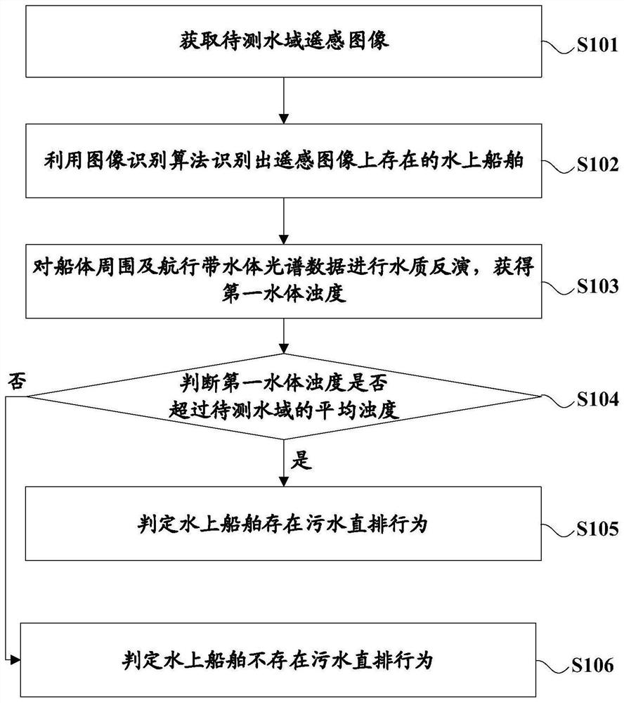
[0032] This embodiment provides a method for identifying pollution from ships on water based on remote sensing technology, please refer to figure 1 , the method mainly includes the following steps:
[0033] S101. Obtain a remote sensing image of the water area to be measured.
[0034] S102. Using an image recognition algorithm to identify the watercraft existing on the remote sensing image.
[0035] The recognition algorithm can adopt the existing intelligent image recognition algorithm, as long as it can recognize the ship existing in the remote sensing image, it will not be repeated here.
[0036] S103. Perform water quality inversion on the spectral data of the water body around the hull and in the navigation zone to obtain the first water body turbidity.
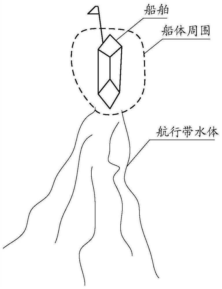
[0037] The area and shape around the hull can be flexibly set according to the actual situation, and the water body in the navigation zone is also the water body after the ship travels. See figure 2 shown.
[0038]...
Embodiment 2
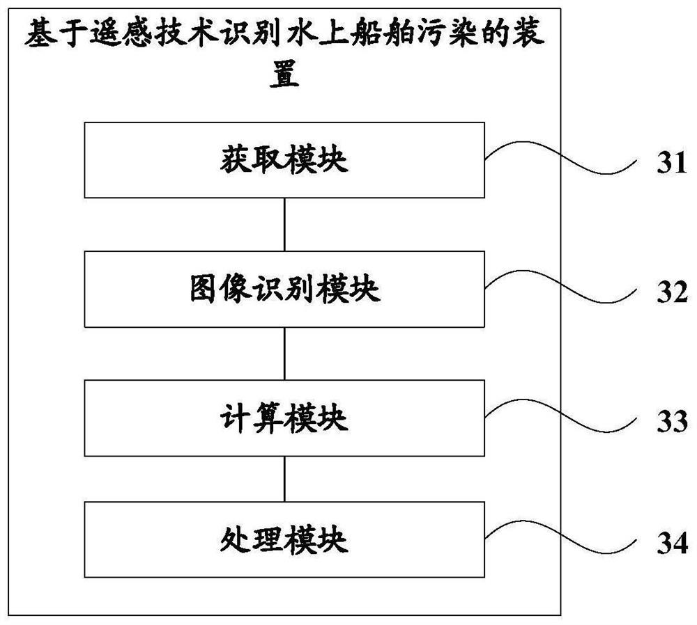
[0050] On the basis of the first embodiment above, this embodiment provides a device for identifying pollution from ships on water based on remote sensing technology, which is used to implement the steps of the method for identifying pollution from ships on water based on remote sensing technology described in the first embodiment. Please refer to image 3 , the device mainly includes the following modules:
[0051] Obtaining module 31 is used for obtaining the remote sensing image of the water area to be measured;
[0052] The image recognition module 32 utilizes an image recognition algorithm to recognize the watercraft existing on the remote sensing image;
[0053] The calculation module 33 is used to perform water quality inversion on the spectral data of the water body around the hull and in the navigation zone to obtain the first water body turbidity;
[0054] The processing module 34 is used to compare the turbidity of the first water body with the average turbidity of...
Embodiment 3
[0061] On the basis of the first embodiment above, this embodiment provides a storage medium, the storage medium stores one or more programs, and the one or more programs can be executed by one or more processors to implement the following The steps of the method for identifying pollution from ships on water based on remote sensing technology described in the first embodiment. For details, refer to the description of Embodiment 1 above, and details are not repeated here.
[0062] Obviously, those skilled in the art should understand that each module or each step of the present invention can be realized by a general-purpose computing device, and they can be concentrated on a single computing device, or distributed on a network formed by multiple computing devices , alternatively, they can be implemented with program codes executable by computing devices, thus, they can be stored in computer storage media (ROM / RAM, magnetic disks, optical disks) to be executed by computing devic...
PUM
 Abstract
Description
Claims
Application Information
 - R&D Engineer
- R&D Manager
- IP Professional
- Industry Leading Data Capabilities
- Powerful AI technology
- Patent DNA Extraction
Browse by: Latest US Patents, China's latest patents, Technical Efficacy Thesaurus, Application Domain, Technology Topic, Popular Technical Reports.
© 2024 PatSnap. All rights reserved.Legal|Privacy policy|Modern Slavery Act Transparency Statement|Sitemap|About US| Contact US: help@patsnap.com


