Multi-temporal forestry remote sensing image change monitoring method

A remote sensing image and change monitoring technology, which is applied in the field of remote sensing change monitoring, can solve problems such as the inability to use spatial context information, high-resolution images with a large amount of calculation, and underutilized images, so as to avoid adjacent broken spots and abnormal graphic holes, Improve universality and promote the effect

Active Publication Date: 2020-12-18
国家林业和草原局中南调查规划设计院
View PDF4 Cites 13 Cited by
  • Summary
  • Abstract
  • Description
  • Claims
  • Application Information

AI Technical Summary

Problems solved by technology

[0004] The thresholding method selects a threshold to threshold the difference image to distinguish between changing and non-changing pixels. The advantage is that the method is simple and clear, but the disadvantage is that it does not make full use of the image context information and is easily affected by factors such as sensor noise and registration errors. influences;
[0005] The pattern classification method uses a classifier to classify different sample data sets to obtain change detection results. Its advantage is to overcome the inaccuracy of simple thresholding methods, and its disadvantage is that it cannot use spatial context information, and artificial neural networks and support vector machines The method requires manual intervention to provide supervision information;
[0006] The multi-scale analysis method uses the multi-scale geometric analysis method for change detection, so as to overcome the influence of factors such as sensor noise and registration error. Its advantage is to overcome factors such as sensor noise and registration error. The technical difficulties of scale result processing have not been resolved;
[0007] The Markov random field method uses the Markov random field model to simulate the spatial context information to obtain the change detection results. High-score image calculations are too large and the calculation time is too long

Method used


Image

  • Multi-temporal forestry remote sensing image change monitoring method
  • Multi-temporal forestry remote sensing image change monitoring method
  • Multi-temporal forestry remote sensing image change monitoring method

Examples


Embodiment Construction

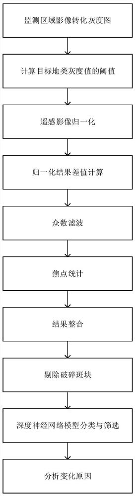
[0061] The present invention will be further described below in conjunction with the accompanying drawings and specific preferred embodiments, but the protection scope of the present invention is not limited thereby.

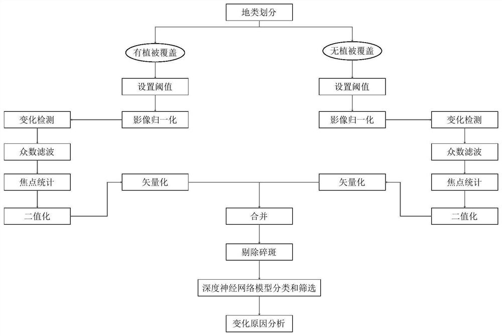
[0062] Such as figure 1 As shown, the multi-temporal forestry remote sensing image change monitoring method of the present invention comprises the following steps:

[0063] S1) Transform the image of the monitoring area into a grayscale image: In order to facilitate the use of grassroots forestry departments, the high-resolution image issued by the National Forestry and Grassland Bureau is a pre-processed false-color image, which is obtained by fusing three bands of infrared, red, and green. Among them, the red light band is most suitable for forestry remote sensing image change detection, so in this embodiment, the red light bands of the first and last two images of the monitoring area are converted into grayscale images;

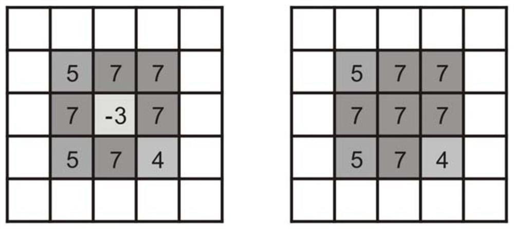
[0064] S2) Calculate the threshold v...


PUM


Abstract

The invention discloses a multi-temporal forestry remote sensing image change monitoring method. The method comprises the following steps: converting a monitoring area image into a grey-scale map; calculating a threshold value of a gray value of a target land type; normalizing the remote sensing image according to the threshold value of the gray value of the target land type to obtain a normalizedfront-stage image and a normalized rear-stage image; carrying out difference calculation on the normalized front-stage image and the normalized rear-stage image corresponding to the different targetland types to obtain image change graphs; respectively carrying out mode filtering and intersection point statistics on the image change graphs of different target land types, then carrying out resultintegration to obtain a vector graph of preliminary change detection, removing broken plaques, and then carrying out classification and screening through a deep neural network model to obtain a vector graph of a final change detection result; and analyzing the change reason of the vector graph of the final change detection result. The terrain of the monitoring area is accurately divided and remote sensing change detection is performed according to the annual updating result of one graph of the forest resource management so that the accurate change detection result can be obtained.

Description

technical field [0001] The invention relates to the field of remote sensing change monitoring, in particular to a multi-temporal forestry remote sensing image change monitoring method. Background technique [0002] Remote sensing change monitoring is the use of multi-temporal remote sensing images, using a variety of image recognition methods to extract change information, and quantitative analysis to determine the characteristics and process of surface changes. It involves the type, distribution, and amount of change, that is, it is necessary to determine the ground type, boundary, and change trend before and after the change, and then analyze the characteristics and causes of these dynamic changes. Remote sensing change monitoring is divided into three methods: pixel level, feature level and target level according to the level of processing objects. Among them, the research on feature-level and target-level change detection is not yet mature, and it is difficult to use it...

Claims


Application Information

Patent Timeline
Patent Type & Authority Applications(China)
IPC IPC(8): G06K9/00G06K9/34G06K9/62G06N3/04
CPCG06V20/188G06V10/267G06N3/045G06F18/23213
Inventor 郭晓妮董雅雯杨宁曾晖姜灿荣肖微付达夫丁山周全胥东海
Owner 国家林业和草原局中南调查规划设计院
Why Eureka
Try Eureka