Method and system for estimating grazing rate based on alpine meadow grass yield
A technology of grazing rate and grass yield, applied in computing, computer parts, character and pattern recognition, etc., can solve problems such as time-consuming and laborious, and achieve the effect of avoiding grassland degradation
- Summary
- Abstract
- Description
- Claims
- Application Information
AI Technical Summary
Problems solved by technology
Method used
Image


Examples
Embodiment 1
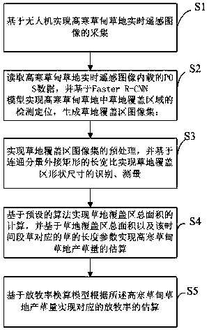
[0037] A method for estimating grazing rate based on alpine meadow grass yield, comprising the following steps:
[0038] S1. Acquisition of real-time remote sensing images of alpine meadows and grasslands based on drones; each remote sensing image of alpine meadows and grasslands carries supporting POS data, which includes latitude, longitude, elevation, heading angle (Phi), and pitch Angle (Omega) and roll angle (Kappa);
[0039] S2. Read the POS data contained in the real-time remote sensing image of the alpine meadow, and realize the detection and positioning of the grass coverage area in the alpine meadow based on the Faster R-CNN model, and generate an image set of the grass coverage area; the Faster R-CNN The model is constructed based on the grassland image set in the historical alpine meadow grassland;
[0040] S3. Realize the preprocessing of the image set of the grassland coverage area, and realize the recognition and measurement of the shape and size of the grassla...
Embodiment 2
[0044] A method for estimating grazing rate based on alpine meadow grass yield, comprising the following steps:
[0045] S1. According to the distribution map of the alpine meadow grassland, the planning of the coordinates of the UAV image acquisition is realized;
[0046] S2. Realize the collection of real-time remote sensing images of alpine meadows and grasslands based on the drone image acquisition coordinates obtained by the UAV according to the planning; each remote sensing image of alpine meadows and grasslands carries supporting POS data, and the POS data includes latitude and longitude , elevation, heading angle (Phi), pitch angle (Omega) and roll angle (Kappa);
[0047] S3. Read the POS data contained in the real-time remote sensing image of the alpine meadow, and realize the detection and positioning of the grass coverage area in the alpine meadow based on the Faster R-CNN model, and generate an image set of the grass coverage area; the Faster R-CNN The model is co...
Embodiment 3
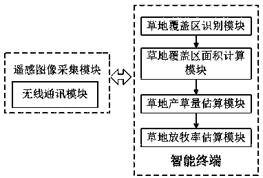
[0052] A system for estimating grazing rate based on grass production in alpine meadows, including a remote sensing image acquisition module and an intelligent terminal with a display that communicates with the remote sensing image acquisition module; Realize the collection of remote sensing images of alpine meadow and grassland regularly, and send the collected remote sensing images of alpine meadow grassland to the smart terminal in real time through the wireless communication module. Each remote sensing image of alpine meadow grassland carries supporting POS data, and the POS The data includes latitude, longitude, elevation, heading angle (Phi), pitch angle (Omega) and roll angle (Kappa); the smart terminal contains:
[0053] Grassland coverage area recognition module, used to realize the recognition of grassland coverage area in alpine meadow grassland remote sensing image; said grassland coverage area recognition module first reads the POS data contained in the real-time r...
PUM
 Abstract
Description
Claims
Application Information
 - Generate Ideas
- Intellectual Property
- Life Sciences
- Materials
- Tech Scout
- Unparalleled Data Quality
- Higher Quality Content
- 60% Fewer Hallucinations
Browse by: Latest US Patents, China's latest patents, Technical Efficacy Thesaurus, Application Domain, Technology Topic, Popular Technical Reports.
© 2025 PatSnap. All rights reserved.Legal|Privacy policy|Modern Slavery Act Transparency Statement|Sitemap|About US| Contact US: help@patsnap.com