Ecological risk assessment method based on urban agglomeration region key industry development
A technology of ecological risk and urban agglomeration, applied in the direction of instruments, data processing applications, resources, etc., can solve the problems of lack of ecological risk assessment of human settlements and other issues
- Summary
- Abstract
- Description
- Claims
- Application Information
AI Technical Summary
Problems solved by technology
Method used
Image
Examples
Embodiment 1
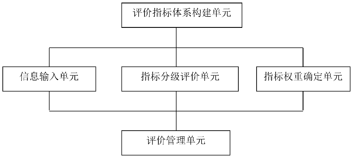
[0024] The present invention is mainly based on the hazard characteristics of the development of key industries, starting from the safety of urban agglomeration human settlements, constructing an evaluation index system from the aspects of key industry development risk sources, exposure, vulnerability of receptors, and risk prevention and control capabilities, and proposes to develop urban agglomeration Ecological risk assessment method for regional key industry development. Those skilled in the art can realize that the described embodiments can be modified in various ways or combinations without departing from the spirit and scope of the present invention. Embodiments of the present invention will be described below with reference to the accompanying drawings.
[0025] The key industry development ecological risk evaluation method described in the present invention comprises the following steps:
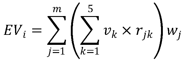
[0026] 1) Evaluation index system construction unit: establish an ecological r...
Embodiment 2
[0038] On the basis of the method in Embodiment 1, the Yangtze River Delta urban agglomeration is taken as an example to describe in detail.
[0039] Table 1 shows the ecological risk evaluation index system for the development of key industries in the Yangtze River Delta urban agglomeration. According to the characteristics of the Yangtze River Delta urban agglomeration, the evaluation index system constructed includes 1 target layer, 4 criterion layers, 10 element layers and 25 index layers. The evaluation indicators of each criterion layer and element layer include multiple different index layer evaluation indicators.
[0040] Refer to the statistical yearbooks, environmental status bulletins, environmental quality reports, water resources bulletins, and environmental statistics of the provinces and cities where the Yangtze River Delta urban agglomeration is located, as well as the 1km×1km Chinese population spatial distribution kilometer grid shared by the Resource and Envi...
PUM
 Abstract
Description
Claims
Application Information
 - R&D Engineer
- R&D Manager
- IP Professional
- Industry Leading Data Capabilities
- Powerful AI technology
- Patent DNA Extraction
Browse by: Latest US Patents, China's latest patents, Technical Efficacy Thesaurus, Application Domain, Technology Topic, Popular Technical Reports.
© 2024 PatSnap. All rights reserved.Legal|Privacy policy|Modern Slavery Act Transparency Statement|Sitemap|About US| Contact US: help@patsnap.com


