Intelligent mine geological environment information evaluation system and evaluation method

A geological environment and evaluation method technology, applied in image data processing, photogrammetry/video measurement, resources, etc., can solve the lack of comprehensiveness and accuracy of evaluation results, poor accuracy of mine geological monitoring and early warning, and difficulty in meeting monitoring needs And other issues

Inactive Publication Date: 2020-06-09
CHANGCHUN INST OF TECH
View PDF7 Cites 13 Cited by
  • Summary
  • Abstract
  • Description
  • Claims
  • Application Information

AI Technical Summary

Problems solved by technology

[0004] (1) The existing mine geological environment evaluation system lacks quantitative design for ecological restoration, and the restoration is designed and constructed relying on engineering experience; the accuracy of mine geological monitoring and early warning is poor, and it is difficult to meet the monitoring needs
[0005] (2) Existing mine geological environment assessment methods are biased towards a single subjective or objective assessment, and the assessment results lack comprehensiveness and accuracy
[0006] (3) The existing mine geological environment assessment methods are mainly aimed at the comprehensive assessment of large-scale and multi-type mines, but lack of targeted assessment for a certain mine

Method used


Image

  • Intelligent mine geological environment information evaluation system and evaluation method
  • Intelligent mine geological environment information evaluation system and evaluation method

Examples


Embodiment 1

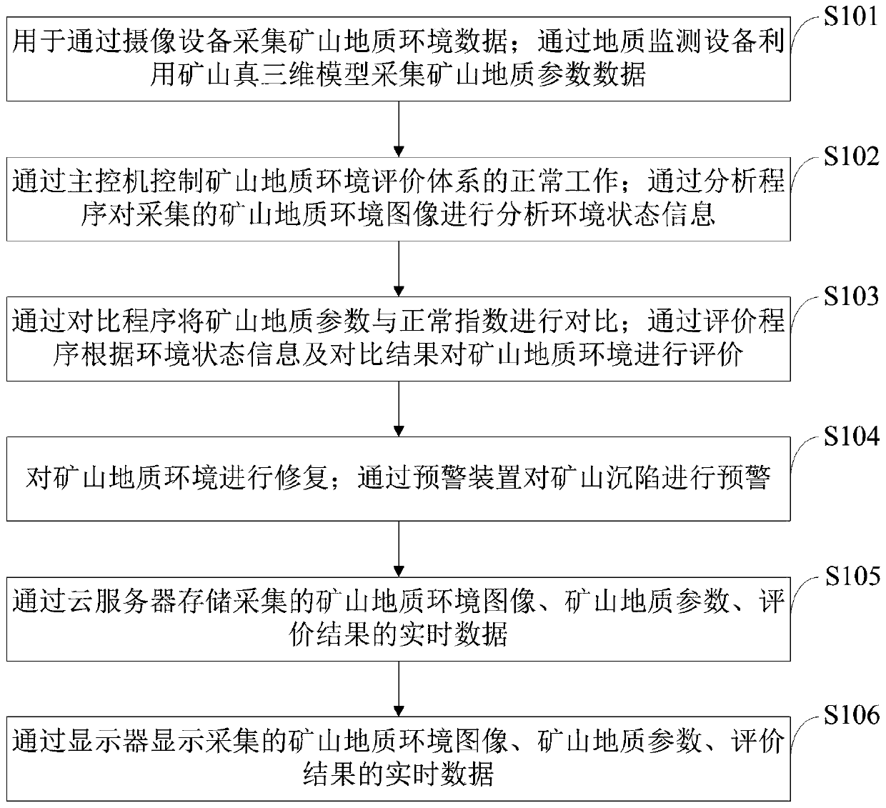
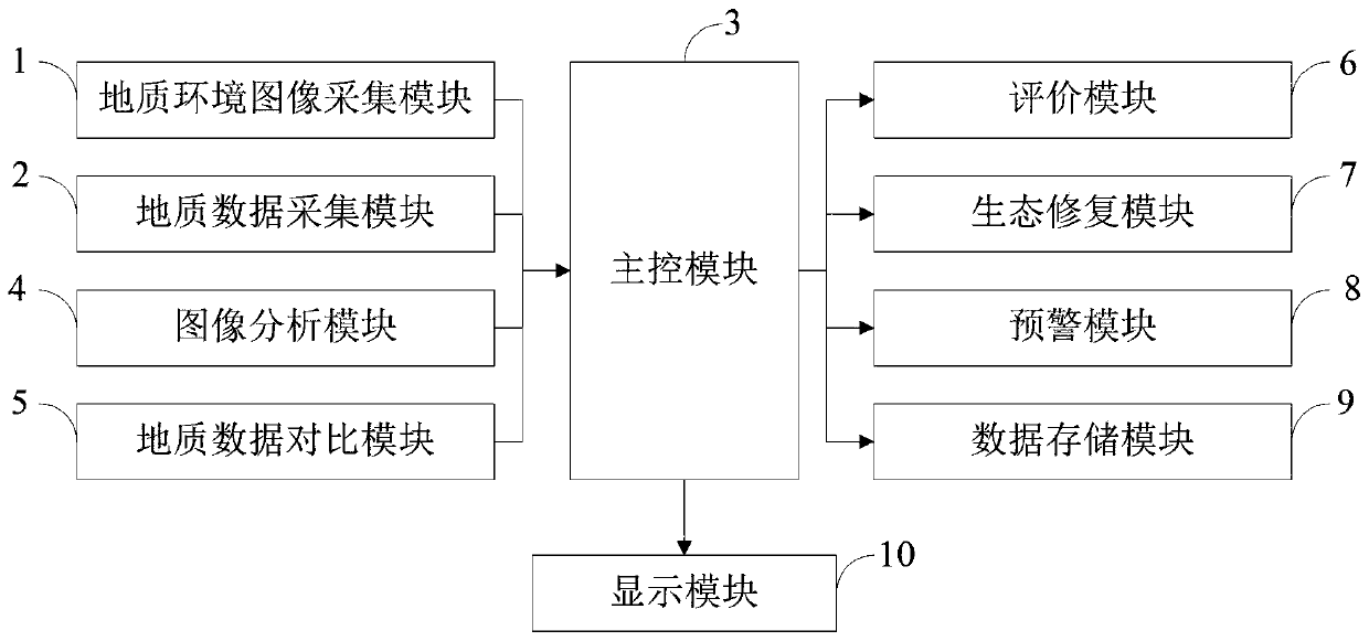
[0100] The intelligent mine geological environment information evaluation method provided by the embodiment of the present invention is as follows: figure 1 As shown, as a preferred embodiment, the method for repairing the mine geological environment provided by the embodiment of the present invention includes:

[0101] 1) Obtain the basic data of the area to be restored in the mine through the evaluation model construction program, and establish a SWAT model for soil and water loss evaluation;

[0102] 2) Carry out ecological divisions according to the SWAT model, and obtain the amount of water and soil loss in each ecological division;

[0103] 3) Use the method of scenario analysis-test correction to determine the repair measures.

[0104] The basic data provided by the embodiments of the present invention include sub-basin division data and soil erosion evaluation data, specifically referring to:

[0105] Sub-watershed division data: digital elevation model data;

[0106]...

Embodiment 2

[0115] The intelligent mine geological environment information evaluation method provided by the embodiment of the present invention is as follows: figure 1 As shown, as a preferred embodiment, the method for evaluating the mine geological environment through the evaluation program according to the environmental state information and the comparison results provided by the embodiment of the present invention includes:

[0116] (1) set up the mine geological environment evaluation layered structure model; The mine geological environment evaluation layered structure model includes three layers, respectively target layer, criterion layer, factor layer;

[0117] (2) construct the evaluation index judgment matrix of each level of structural model; According to described evaluation index judgment matrix, calculate the weight value of the evaluation index of each level corresponding to evaluation index judgment matrix, determine effective evaluation index;

[0118] (3) Carrying out no...

Embodiment 3

[0140] The intelligent mine geological environment information evaluation method provided by the embodiment of the present invention is as follows: figure 1 As shown, as a preferred embodiment, the method for early warning of mine subsidence through the early warning device provided by the embodiment of the present invention is:

[0141] (1) Deploy and control the monitoring points in the mining area, and conduct regular observations to obtain the level elevation data and GPS horizontal position data of the monitoring points;

[0142] (2) Use Matlab software to interpolate discrete measurement data to construct a digital elevation model;

[0143] (3) Perform two-track differential interference processing on the synthetic aperture radar interferometric image of the mining area and the constructed digital elevation model, and obtain the monitoring results of the surface shape deformation of the mining area;

[0144] (4) Use GPS and level monitoring data to correct the horizonta...


PUM


Abstract

The invention belongs to the technical field of geological environment evaluation, and discloses an intelligent mine geological environment information evaluation method and system. The method comprises the steps: collecting mine geological environment data and geological parameter data; the mine geological environment evaluation system is controlled through the main control computer; analyzing the environment state information, comparing the mine geological parameters with normal indexes, and performing restoration, evaluation and mine subsidence early warning on the mine geological environment; and storing and displaying the mine geological environment image, the geological parameters and the evaluation result. Starting from two factors of soil and vegetation influencing ecological restoration of the mine, ecological zoning is conducted on the mine to be restored through data collection by means of the ecological restoration module, proper soil improvement and vegetation coverage measures are selected, and the purpose of ecological restoration of the mine is achieved; and the InSAR monitoring result is corrected by adopting high-precision level data through the early warning module, so that the accuracy of the three-dimensional deformation monitoring result of the mining area is greatly improved.

Description

technical field [0001] The invention belongs to the technical field of geological environment evaluation, and in particular relates to an intelligent mine geological environment information evaluation system and evaluation method. Background technique [0002] The geological environment mainly refers to the hard shell below the earth's surface, namely the lithosphere. The geological environment is a product of the evolution of the earth. The weathering process of rocks under the action of solar energy liberates the consolidated matter and participates in the geographical environment, the geological cycle and even the great cycle of interstellar matter. A system composed of rocks, topsoil, water and the atmosphere; some people think that the geological environment is only composed of rocks and their weathered products -- topsoil. Human beings and other organisms depend on the geological environment for survival and development, and at the same time, the activities of human ...

Claims


Application Information

Patent Timeline
IPC IPC(8): G06Q10/06G06T17/05G01C11/00G01C5/00
CPCG06Q10/06393G06T17/05G01C5/00G01C11/00
Inventor 薛晓刚李彩虹谷中元迟唤昭陈国强秦宏宇
Owner CHANGCHUN INST OF TECH
Why Eureka
Try Eureka