Step-by-step decomposition method for shallow sea complex terrain
A complex terrain and terrain technology, applied in complex mathematical operations, instruments, surveying and navigation, etc., can solve problems such as difficult quantification and research of complex submarine terrain
- Summary
- Abstract
- Description
- Claims
- Application Information
AI Technical Summary
Problems solved by technology
Method used
Image
Examples
Embodiment 1
[0042] Embodiment 1 Implementation process of a step-by-step decomposition method for shallow sea complex terrain
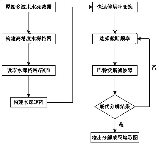
[0043] Such as figure 1 As shown, this embodiment describes a step-by-step decomposition method for shallow sea complex terrain based on the combination of Fourier transform and Butterworth filter principles, including the following main steps:
[0044] 1) Data preprocessing: CUBE filtering, sound velocity correction, tide level correction and other data processing processes are performed on the original multi-beam water depth data obtained by survey, and a high-precision digital water depth model is constructed;
[0045] 2) Frequency analysis: One-dimensional and two-dimensional Fourier transforms are used to transform the superimposed terrain from the space domain to the frequency domain.
[0046] In the spatial domain terrain signal, the spatial frequency is the number of periodic occurrences per unit distance, and the unit is 1 / m. A discrete signal sequence ...
Embodiment 2
[0066] Embodiment 2 Take the typical sand wave terrain in shallow sea as an example for specific application
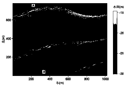
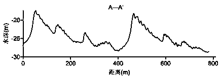
[0067] by Figure 2(a) , 2(b) The data shown are taken as an example to verify the method. The data shown is the full-coverage water depth data obtained by multi-beam survey, with a resolution of 1×1m. Figure 2(a) shows the plane terrain, and Figure 2(b) intercepts a sand wave profile, which shows various scales The sand wave terrain is superimposed to form a complex shallow sea terrain. According to the method flow in Embodiment 1, the terrain signal is transformed into the frequency domain by Fourier transform, and decomposed step by step into sand wave terrain with different frequencies through frequency division processing. After grayscale transformation, the terrain grayscale image is obtained. Figure 3(a)-(c) shows the three types of terrain grayscale images finally decomposed.
[0068] Figure 4 is the definition method of sand wave shape parameters, the w...
PUM
 Abstract
Description
Claims
Application Information
 - Generate Ideas
- Intellectual Property
- Life Sciences
- Materials
- Tech Scout
- Unparalleled Data Quality
- Higher Quality Content
- 60% Fewer Hallucinations
Browse by: Latest US Patents, China's latest patents, Technical Efficacy Thesaurus, Application Domain, Technology Topic, Popular Technical Reports.
© 2025 PatSnap. All rights reserved.Legal|Privacy policy|Modern Slavery Act Transparency Statement|Sitemap|About US| Contact US: help@patsnap.com


